Sold2024Tartaria d'Europa overo Piccola Tartaria. Little Tartary. Ukraine ROSSI 1684 mapTITLE/CONTENT OF MAP: Tartaria d'Europa overo Piccola Tartaria [European, or Little Tartary] The Black Sea, Ukraine, the Russian Caucasus and Georgia DATE PRINTED: 1684 IMAGE SIZE: Approx 44.5 x 56.0cSee Sold Price
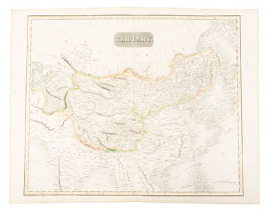
Sold2024La Gran Tartaria. Great Tartary. Central/North Asia. ROSSI / CANTELLI 1683 mapTitle: La Gran Tartaria. Great Tartary. Central/North Asia. ROSSI / CANTELLI 1683 map Description: La Gran Tartaria divisa nelle sue parti principali [Great Tartary divided into its main parts] by PubSee Sold Price
Sold20181720 Homann Map of Black Sea, Southern Russia andTitle/Content of Map: 1720 Homann Map of Black Sea, Southern Russia and Ukraine -- Tabula Geographica qua pars Russiae Magnae Pontus Euxinus seu Mare Nigrum et Tartaria Minor cum finitimis Bulgariae,See Sold Price
Sold2024L'Irlanda o'vero Hibernia. Ireland. DE ROSSI 1689 old antique map plan chartTITLE/CONTENT OF MAP: L'Irlanda o'vero Hibernia [Ireland, or Hibernia] DATE PRINTED: 1689 IMAGE SIZE: Approx 59.0 x 45.0cm, 23.25 x 17.75 inches (Large) TYPE: Antique 17th century folio atlas map CONDSee Sold Price
Sold2021H. Moll, 1736, Map includes Moscovy & PolandAlso includes Little Tartary and the Black Sea. Dedicated to Peter Alexovitz, Absolute Lord of Russia. 1736. Constructed in 2 panels; hand colored. Tears to bottom at folds. Tears and losses to rightSee Sold Price
Sold2018First Part of Turkey in Europe' by DUNN/LAURIE &TITLE/CONTENT OF MAP: 'First Part of Turkey in Europe containing Moldavia with Bukovina and Little Tartary with Krimea now called Tauris, to which is added the whole of the Black Sea' A map of the BlaSee Sold Price
Sold20181689 Antique Map of Scandinavia Giovanni De Rossi’sDe Rossi Scandinavia Map from an edition of Giovanni Giacomo de Rossis Mercurio Geografico Overo Guida Geografica in Tutte le Parti del Mondo. Hand colored outline. Double page. La Scandinavia DivisaSee Sold Price
Sold20182 Maps by de Rossi incl: Regno Di Napoli.2 Maps from Giovanni Giacomo de Rossi’s “Mercurio Geografico Overo Guida Geografica in Tutte le Parti del Mondo.” ++ Regno Di Napoli. A revised version of a map of Naples by Giacomo Cantelli daSee Sold Price
Sold20181689 Antique Map of Prussia Giovanni Giacomo De Rossi’sDe Rossi PRUSSIA Map from an edition of Giovanni Giacomo de Rossis Mercurio Geografico Overo Guida Geografica in Tutte le Parti del Mondo. La Prussia Divisa In Reale Che Appartiene Al Re Di Polonia: 1See Sold Price
Sold2024L'Europa. Europe. DE ROSSI 1677 old antique vintage map plan chartTITLE/CONTENT OF MAP: L'Europa [Europe] DATE PRINTED: 1677 IMAGE SIZE: Approx 44.0 x 56.5cm, 17.25 x 22.25 inches (Large) TYPE: Antique 17th century folio atlas map CONDITION: Good; suitable for framiSee Sold Price
Sold2023MAP, Greece, Cantelli da VignolaNorthern Greece, Albania, & Macedonia. Cantelli da Vignola/de Rossi, Macedonia Epiro Livadia Albania e Ianna..., from Mercurio Geografico..., 1684 (dated). Hand Color. This handsome Italian map of norSee Sold Price
Sold2019Pictorial antique maps TartaryThis is a highly decorative 1851 map of Independent Tartary by John Tallis and John Rapkin. It covers the regions between the Caspian Sea and Lake Bakquash and between Russia and Afghanistan. These inSee Sold Price
Sold2023A framed 17th century map of Tartary by HondiusA framed 17th century map of Tartary by Jodocus Hondius the Elder (1563-1612). This was first issued in 1606 and continued to be printed by Hondius wife and sons in the decades after the elder HondiusSee Sold Price
Sold2023John Speede, "A New Map of Tartary"Or: "A Newe Mape of Tartary." Hand colored map "augmented" by British cartographer John Speede (1551 - 1629). Originally sold by London merchants Thomas Bassett of Fleet Street and Richard Chiswell inSee Sold Price
Sold2022John Speede Map of TartaryDESCRIPTION: John Speede A Newe Mape of Tartary. From the first world atlas produced in England. Includes a decorative carte à figures. Side panels depict costumed figures, above are vignettes of tSee Sold Price
Sold20241630 MAP OF TARTARY CHINA RUSSIA copper engraving ANTIQUEEarly 17th century map of Tartary, reduced from the larger edition of the map which appeared in the French Mercator-Jodocus Hondius Atlas Minor in the 1630s. Very fine and decorative engraving showingSee Sold Price
Sold2018Bonne: Antique Map of Tartary China Korea Japan, 1787Item: Map of Tartary China Korea Japan 1787 Bonne Etching On Copper Very beautiful map of Tartary, China, Korea and Japan Author: Bonne Rigobert (1727-1794) Atlas: Atlas de toutes parties connues du gSee Sold Price
Sold20231630 MAP OF TARTARY CHINA RUSSIA copper engraving ANTIQUEEarly 17th century map of Tartary, reduced from the larger edition of the map which appeared in the French Mercator-Jodocus Hondius Atlas Minor in the 1630s. Very fine and decorative engraving showingSee Sold Price
Sold20181732 Moll Map of Tartary and Central Asia -- GreatTitle/Content of Map: 1732 Moll Map of Tartary and Central Asia -- Great Tartary. With the Tract of the Moscovite Ambassador's Travels from Moscow to Pekin in China… Date Printed: 1732, London CartoSee Sold Price
Sold20241851 Tallis Map of Tartary -- Part of Russia in Asia, and Independent TartaryTitle: 1851 Tallis Map of Tartary -- Part of Russia in Asia, and Independent Tartary Cartographer: J Tallis Year / Place: 1851 c., London Map Dimension (in.): 10 X 13 in. This is a rarely seen TallisSee Sold Price
Sold2017Bellin: Antique Map of Tartary, Tibet, Silk-Road ChinaMap: Carte de l'Empire de Hya et Partie de Tangut Cartographer: Bellin Place & Date: Paris / 1749/1760 Size: 12 1/8" x 8 5/8" Condition: outline color; overall age toning, some minor spotting, and a lSee Sold Price
Sold2019Map of Tartary comprising most of AsiaHeading: (Maps) Author: Thomson, John Title: Tartary Place Published: Edinburgh Publisher: Date Published: 1814 Description: Engraved map, hand-colored in outline. 49.8x59.5See Sold Price
Sold2017Bellin: Antique Map of Mongolia Tartary Region, 1750Map: Mongolia Tartary Region Date Printed: 1750-60's Cartographer: Jacques Nicolas Bellin Material/Medium: Paper Size: 14" x 9 3/4" Condition: Excellent Copperplate engraving. Double page Map. From thSee Sold Price
Sold20191870 Knox Voyages to ASIA Siberia China Tartary1870 Knox Voyages to ASIA Siberia China Tartary Illustrated Mongolia MAPS Russia Thomas Wallace Knox was a 19th-century traveler known for his writings on his voyages. This 1871 printing of ‘OverlanSee Sold Price
May 22Jasper52La Tartaria Indipendente… Central Asia, Caspian Sea & Caucasus. ZATTA 1785 mapUS$100
21 hrs LeftJasper52Corso del Danubio da Belgrado fino al Mar Ner. Danube. ROSSI / CANTELLI 1684 mapUS$160
21 hrs LeftJasper52Dalmatia, Istria, Bosnia, Servia, Croatia… ROSSI / CANTELLI DA VIGNOLA 1684 mapUS$260
Featured21 hrs LeftJasper52Il Regno d'Ungaria, Transilvania… Bosnia, Croatia… DE ROSSI / SANSON 1683 mapUS$160
May 22Jasper52Carte L’Asie. Asia. Mughal Empire. Oirat Kingdom. Tartary. VAUGONDY 1750 mapUS$280
21 hrs LeftJasper52Turchia d'Europa… Turkey in Europe. Balkans Greece Bulgaria &c. ZATTA 1783 mapUS$55


![Tartaria d'Europa overo Piccola Tartaria. Little Tartary. Ukraine ROSSI 1684 map: TITLE/CONTENT OF MAP: Tartaria d'Europa overo Piccola Tartaria [European, or Little Tartary] The Black Sea, Ukraine, the Russian Caucasus and Georgia DATE PRINTED: 1684 IMAGE SIZE: Approx 44.5 x 56.0c](https://p1.liveauctioneers.com/5584/320546/172232187_1_x.jpg?height=310&quality=70&version=1709072904)


![La Gran Tartaria. Great Tartary. Central/North Asia. ROSSI / CANTELLI 1683 map: Title: La Gran Tartaria. Great Tartary. Central/North Asia. ROSSI / CANTELLI 1683 map Description: La Gran Tartaria divisa nelle sue parti principali [Great Tartary divided into its main parts] by Pub](https://p1.liveauctioneers.com/5584/314775/168780611_1_x.jpg?height=310&quality=70&version=1704837726)

![L'Irlanda o'vero Hibernia. Ireland. DE ROSSI 1689 old antique map plan chart: TITLE/CONTENT OF MAP: L'Irlanda o'vero Hibernia [Ireland, or Hibernia] DATE PRINTED: 1689 IMAGE SIZE: Approx 59.0 x 45.0cm, 23.25 x 17.75 inches (Large) TYPE: Antique 17th century folio atlas map COND](https://p1.liveauctioneers.com/5584/326140/175577116_1_x.jpg?height=310&quality=70&version=1713288521)


![L'Europa. Europe. DE ROSSI 1677 old antique vintage map plan chart: TITLE/CONTENT OF MAP: L'Europa [Europe] DATE PRINTED: 1677 IMAGE SIZE: Approx 44.0 x 56.5cm, 17.25 x 22.25 inches (Large) TYPE: Antique 17th century folio atlas map CONDITION: Good; suitable for frami](https://p1.liveauctioneers.com/5584/322790/173578184_1_x.jpg?height=310&quality=70&version=1710881198)


![CENTRAL ASIA. Karasm [Khwarezm] Great Bochara [Bukhara] Usbeck Tartary 1746 map (1 of 1)](https://p1.liveauctioneers.com/5584/329387/177649411_1_x.jpg?height=282&quality=70&version=1715717898)


