Sold2024The Kennebunk region: a guide to churches, historic points, famouslandmarks: a detailed map ofTitle: The Kennebunk region: a guide to churches, historic points, famouslandmarks: a detailed map of coast, rivers and highways including historical facts and legends Author: Edward Mayo (CartographeSee Sold Price
Sold2021San Antonio Conservation Society 1926 MapVintage 1926 San Antonio Conservation Society historic guide map of San Antonio de Bexar, drawn by Emily Edwards, portrays San Antonio from 1682-1721, unframed 39 x 28"; Provenance: A Schertz, TX EsSee Sold Price
Sold2022San Antonio Conservation Society 1926 MapVintage 1926 San Antonio Conservation Society historic guide map of San Antonio de Bexar, drawn by Emily Edwards, portrays San Antonio from 1685-1721, framed, dated 1926 41"h x 30"w Provenance: A SSee Sold Price
Sold2021Ukraine, one of the earliest detailed maps of theTitle: Ukraine, one of the earliest detailed maps of the country. 1762 by Homann Heirs Date/Period: 1762 Materials: Copperplate engraved Size: 24 x 20 1/2" The best detailed early map of the region. SSee Sold Price
Sold2023A group of stone pointsA group of stone pointsPre-historic or laterComprising five trays of various points of differing stones, shapes and sizes, including arrowheads, points, and hooks, from various regions including NevadSee Sold Price
Sold2022(NEW ORLEANS.) Benjamin Moore Norman. Norman's Plan of New Orleans & Environs.(NEW ORLEANS.) Benjamin Moore Norman. Norman's Plan of New Orleans & Environs. Finely detailed hand-colored engraved pocket map of New Orleans with an 86-point keyed reference panel. 17¾x24½See Sold Price
Sold2022A RARE 18TH CENTURY MAHOGANY FRAMED LARGE TRIPLE FOLDING SCREEN DEPICTING A DETAILED MAP OF THE CITYA RARE 18TH CENTURY MAHOGANY FRAMED LARGE TRIPLE FOLDING SCREEN DEPICTING A DETAILED MAP OF THE CITY OF LONDON from a bound volume of the Cities of London and Westminster and Southwark and ten-mile raSee Sold Price
Sold2021MID-20TH CENTURY GUIDE MAP OF CAPE COD, FEATURINGEDAVILLE RAILROAD. HAND PAINTED ON BOARD. FRAMED. OVERALL SIZE 93 1/2" X 50 1/2". OVERALL GOOD CONDITION.See Sold Price
Sold2018Antique John Smith Atlantic Region Map Virginia OrigState 10: Page 41, numbers changed to 1690 and 1691. A true piece of American history, not a reproduction!Fine example of John Smith's map of the newly formed Virginia colony, one of the true milestonSee Sold Price
Sold2021c 1730 Seutter Map: Novi Belgii, in America ...Historic Maps c. 1730 Historic Rare Earlier State of Seutter's Important American Northeast Map & New York City Restitutio View c. 1730 Hand-Colored Copper-Engraved Map titled, "Recens Edita totius NoSee Sold Price
Sold2022China.- Ortelius (Abraham) Chinae, olim Sinarum regionis, nova descriptio, 1584 [but slightlyChina.- Ortelius (Abraham) Chinae, olim Sinarum regionis, nova descriptio, detailed map centred on China and based on the work of Jorge de Barbuda, a Portuguese Jesuit also known as Ludovicus GeorgiusSee Sold Price
Sold2022MACLEOD, Alexander Samuel (1888-1956). A Map of Honolulu an...MACLEOD, Alexander Samuel (1888-1956). A Map of Honolulu and the Sandwich Islands which we now call the Hawaiian Islands. 1927. New York: Henry M. Snyder. Scarce and detailed map of Honolulu, with anSee Sold Price
Sold20211721 Map of America With California as an IslandHistoric Maps 1721 Hand-Colored "A New Map of America from the Latest Observations" with "California" Shown as an Island 1721 Hand-Colored Engraved Western Hemisphere Map titled, "A New Map of AmericaSee Sold Price
Sold2022Rolex Submariner Date Watch 126610LVThe Rolex Submariner has set the ultimate standard for divers watches. Representing a historic turning point, the timepiece features a green Cerachrom unidirectional bezel, a black Oystersteel 41mm diSee Sold Price
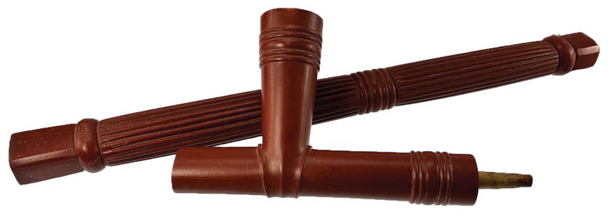
Sold202223" Catlinite Pipe and Stem. Davis G10 COA. Ex-Fred23" Catlinite Pipe and Stem. Detailed. Older Historic example, 1800's. Detailed decoration with fully fluted stem. Very fine condition. Ex-Michael Johnson, Gilbert Cooper, Fred Eiserman. Davis G10 COASee Sold Price
Sold2023Kobe Bryant Signed Scorecard & 16x20 PhotoUp for auction is an incredibly unique and rare item - a Kobe Bryant signed scoring report from the legendary game in which Kobe Bryant scored a stunning 81 points. This historic game, played on JanuaSee Sold Price
Sold2024Exceptional 18th Century Map of The Carolinas, Maryland and VirginiaBy Johann Baptist Homann, Germany, late 17th/early 18th century. Hand colored map of the region which is excellent and quite rare. The map giving excellent details of the region and having exquisite eSee Sold Price
Sold2020Japanese 6-Panel Screen Map, c. 19th CenturyA Japanese hand painted screen possibly depicting a map of bay regions in Japan. The piece is presented predominantly in shades of blue and brown with vibrant gilt detailing. The screen features six pSee Sold Price
Sold2022China.- Speed (John) The Kingdome of China newly augmented, 1626.China.- Speed (John) The Kingdome of China newly augmented, the only carte-a-figures map made of the region, showing China, Korea and Japan, with 8 costumed figures along the left and right borders, aSee Sold Price
Sold20219 Adirondack Mountain Maps & Pamphlets,1870-90'sCollection 1870s Adirondack Mountain Maps & Pamphlets. Includes the historic Preliminary Survey of the Adirondacks made by Verplanck Colvin in 1893, two "Birch Bark from the Adirondacks" books from 18See Sold Price
Sold20224 1/8" Pike County Point. Walnut Ridge, AR. Jackson COA. Pict.4 1/8" Pike County Point. Walnut Ridge, AR. Very thin, with detailed edgework. Excellent symmetry. Made of Bullseye Crowley's Ridge, it exhibits an attracive bullseye across the face. Found by Terry DSee Sold Price
Sold2022Rare Tony Sarg Colored Map of New Hope, Pennsylvania 1941Rare Tony Sarg (1880-1942) Colored Map of New Hope, Pennsylvania 1941, depicting George Washington crossing the Delaware River among other local points of interest 19 in. x 25 in. Framed 27.5 in. x 33See Sold Price
Sold2022Gustave Alaux, pilgrims and mayflower depart, detailedGustave Alaux large oil on canvas depicting hundreds of pilgrims boarding the Mayflower for their historic voyage across the Atlantic to America, highly detailed figures, boats, and the port of PlymouSee Sold Price
Sold2024Anna Pottery Railroad and River Guide FlaskAmerican Second Half 19th Century. Pig Shaped with river and railroad map and inscribed "With a little good old rye in hogs.."See Sold Price
5 days LeftPotter & Potter AuctionsBOLLMANN, Hermann (1911 – 1971). Map of New York City. 1962.US$100
5 days LeftPotter & Potter AuctionsBOUCHER, Lucien (1889 – 1971). Provence Breguet 763 / Air F...US$300
5 days LeftPotter & Potter AuctionsBODLEY, Helen (1906 – 1997). A Map of Concord / The Old Mus...US$400
1 day LeftSchilb Antiquarian Rare Books1883 World Religion Worship Pagan Occult Egypt Temple Isis Angkor Wat MinervaUS$50(8 bids)
7 hrs LeftThousand Planet Auction HouseAn Ancient Bactria-Margiana Steatite and Limestone Idol, c. 2300-1700 BCEUS$5(1 bid)
5 days LeftPotter & Potter AuctionsCrosby Service Pictorial Map of Manhattan (New York City). ...US$250