Sold2022Cram's Double Sided Railway Map in Industrial Frame, New York & S. New England, MA, CT & RICram's Double Sided Railway Map in Industrial Frame, New York & S. New England, MA, CT & RI. Fantastic educational maps on hard board showing railways and census information are marked The George CramSee Sold Price
Sold2019New England states, MI, MA, NH, VT, CT, RITitle/Content of Map: New England states, MI, MA, NH, VT, CT, RI Date: 1861 Cartographer: Johnson Material/Medium: steel engraved Size: 28x14” Provenance: New York Additional Info: Hand colored ReseSee Sold Price
Sold2023Lot of Firefighting RibbonsLarge lot of early firefighting ribbons from the New England area. Towns include: Worcester Ma, Fair Haven Ct, Fall River Ma, Kittery Me, Pawtucket Ri, Newburyport Ma, Littleton Nh, and more. A collecSee Sold Price
Sold2019Framed Map of Yorkshire, EnglandEast Riding Division, home of Thomas Tenney before migrating to New England. Map makers: Christopher Saxton, Surveyor and Cartographer; William Kip, Engraver and Printer. [Map: 7 x 9 inches; Frame: 14See Sold Price
Sold2022New England States Misc. Early Billheads (27) [144981]Includes RI, (4) - MA (14) - PA, (3) - NH, (4) - CT, (2) Dates 1872-1903Date: Country (if not USA): State: New EnglandCity: Provenance:See Sold Price
Sold2022Thomas Nason, Wood Engraving of ChurchThomas W. Nason (American [MA / CT], 1889 - 1971), Wood engraving of a New England church, likely Connecticut. Ca. mid to late 20th century. Signed by artist in lower right (pencil) and signed in platSee Sold Price
Sold2022Salmon & Jeffreys 1749 Lot of 3 Maps with faultsIncl Germany, Hungary/Turkey, and England/Wales. Copper Engraved Map Published 1749, London for "A New Geographical and Historical Grammar" First or Early Edition by Thomas Salmon. Engraved by ThomasSee Sold Price
Sold2016AHM HO Spirit of 76 Boxcar SetAHM HO Spirit of 76 box car train set, includes 16 pcs. 2- diesel engines (motorized & dummy) 1776, box cars for 13 states, CT, NH, MA, RI, NY, NJ, PA, VA, DE, MD, NC, SC, GA, & 1776 American BicentenSee Sold Price
Sold2024Case of 18 Magnetic Map 100 pc PuzzlesCase of 18 Magnetic MA, RI, CT Map 100 pc Puzzles . Geotoys brandSee Sold Price
Sold2016THOMAS ROWLANDSON (ENGLISH 1756-1827) WATERCOLORFramed watercolor on paper, The Posting Inn, paper watermarked 1802, signed lower left Rowlandson (Thomas Rowlandson, England 1756-1827), M.A. McDonald NY label verso, sight: 7.25"h, 10.25"w, overall:See Sold Price
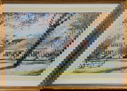
Sold2023A. N. Wyeth (CT, NY, Born 1948) New England house portrait watercolorA. N. Wyeth (CT, NY, Born 1948) New England house portrait, watercolor. Signed A.N.W. '78 lower left. Andrew Nathaniel Wyeth is a grandson of N.C. Wyeth and a nephew of Andrew Wyeth. His father was NaSee Sold Price
Sold202118TH C. (1755) MAP OF N.Y. , PENSYLVANIA & NEW ENGLANDFRAMED 18TH C. (DATED 1755) 2 PART MAP "A MAP OF THE PROVINCE OF NEW YORK, WITH PART OF PENSILVANIA AND NEW ENGLAND / FROM AN ACTUAL SURVEY BY CAPTAIN MONTRESOR, ENGINEER 1755" - FRAME 59 1/4" X 39",See Sold Price
Sold2023That part of America which was… New England NY St Lawrence. GENTS MAG 1757 mapTitle: That part of America which was… New England NY St Lawrence. GENTS MAG 1757 map Description: A map of that part of America which was the principal seat of war in 1756' by Unattributed (175See Sold Price
Sold2016Lionel Spirit of 76 Bi-centennial Freight SetLionel 15 pc. Spirit of 76 Bi-centennial freight set, includes 1776 engine, box cars, NC, SC, MD, NH, MA, CT, VA, NY, GA, RI, DE, NJ, PA, & 7600 cabooseSee Sold Price
Sold2023Collection of Vintage United States MapsAntique antique MAPS, mainly New England, Mid-Atlantic, Virginia, and more. Approximately 50 pieces. As is, as shown. Provenance: Phyllis Lucas Gallery, NYC.See Sold Price
Sold2017H. Moll: Antique Map of New England & mid Atlantic 1746Title/Content of Map: Important and rare Map of New England & mid Atlantic colonial America Date Printed: 1746 Cartographer: Thomas Salmon & Herman Moll Material/Medium: Paper Size: 14 1/2" x 9 1/2" CSee Sold Price
Sold20231758 Folding Map of New England and Nova ScotiaA Map of New England and Nova Scotia with part of New York, Canada, and New Britain and the adjacent Islands of New Found Land and Cae Breton, by Thomas Kitchin, printed at London for London Magazine,See Sold Price
Sold20242 Maps CT and RI & General Grant's Long Island2 18th / 19th century maps. H. Harris Rhode Island & Connecticut, hand colored, circa 1802, Thomas and Andrews, 8" x 13 1/2" (with frame 16" x 20 3/4"); Charles Stedman & William Faden Sketch of GenerSee Sold Price
Sold2022Post Card AlbumPost card album containing aproximately 255 cards mostly NY cards, also has Ct, MA and RISee Sold Price
Sold2022Postal Cancellation Collection, 34 [153363]34 covers with various cancels. Newport, RI, New London, CT, Tannersville, NY, New Brighton, NY, Grahamsville, NY Buffalo, NY, Rye ,NY and more. Mostly c. 1880's-1890's.Date: Country (if not USA): StaSee Sold Price
Sold2023Seven Pewter PlatesSmooth rim plate by Samuel Hamlin Sr. 1767-1801, Hartford CT and Providence, RI or Samuel E Hamlin Jr. 1801-1856. Providence RI with Jacobs 159 mark. Diameter 9-3/16". Pewter smooth brim by Samuel HarSee Sold Price
Sold2021Striking RR map of Mass., Conn. R.I., 1875Dynamic, detailed map of three New England states, beautifully hand colored by townships. Extends to Nantucket, Martha's Vineyard and Block Island. Shows rail lines very prominently, along with towns,See Sold Price
Sold2021New England railroad ephemera, large collection ofNew England railroad ephemera, large collection of historical documents, from 1857 to 1910, including paperwork from: Naugatuck R.R. Co., Hartford & CT River Valley R.R., NY & New Haven R.R., MilfordSee Sold Price
Sold2022Stanley Sobossek (American, N.Y. 1918-1996) INLET-BERKSHIRE, MA 1960sNew England Berkshire Mountains Modernist Landscape Painting, signed and titled by the artist, Stanley Sobossek. Circa 1960s. Title: Inlet Berkshire. Oil on canvas signed and titled on verso: StanleySee Sold Price
Jun 07Freeman's | Hindman[HARDY, Thomas]. -- WINDLE, C.A. The Wessex of Thomas Hardy. Edmund H. New, illustrator. 1902.US$200
6 days LeftSchilb Antiquarian Rare Books1871 Alfred the Great King of England MAP Battle of Ashdown Vikings Thom HughesUS$125(3 bids)


![New England States Misc. Early Billheads (27) [144981]: Includes RI, (4) - MA (14) - PA, (3) - NH, (4) - CT, (2) Dates 1872-1903Date: Country (if not USA): State: New EnglandCity: Provenance:](https://p1.liveauctioneers.com/2699/237258/122967577_1_x.jpg?height=310&quality=70&version=1644622775)
![Thomas Nason, Wood Engraving of Church: Thomas W. Nason (American [MA / CT], 1889 - 1971), Wood engraving of a New England church, likely Connecticut. Ca. mid to late 20th century. Signed by artist in lower right (pencil) and signed in plat](https://p1.liveauctioneers.com/1163/240017/124416447_1_x.jpg?height=310&quality=70&version=1646675148)


![Postal Cancellation Collection, 34 [153363]: 34 covers with various cancels. Newport, RI, New London, CT, Tannersville, NY, New Brighton, NY, Grahamsville, NY Buffalo, NY, Rye ,NY and more. Mostly c. 1880's-1890's.Date: Country (if not USA): Sta](https://p1.liveauctioneers.com/2699/254716/132469346_1_x.jpg?height=310&quality=70&version=1657564123)


![[HARDY, Thomas]. -- WINDLE, C.A. The Wessex of Thomas Hardy. Edmund H. New, illustrator. 1902. (1 of 3)](https://p1.liveauctioneers.com/197/329395/177650387_1_x.jpg?height=282&quality=70&version=1715364962)


![[BOOKS] CIVIL WAR. LOT OF 6 VOLUMES SOLD TOGETHER (1 of 1)](https://p1.liveauctioneers.com/8124/329546/177689810_1_x.jpg?height=282&quality=70&version=1715469494)


