Sold2024Town and Village Map of Skaneateles 1856Onondaga County, NY surveyed and drawn by Frank French. Published by J.H. French Philadelphia. Map is in fair to good condition with some tears and staining. Framed and under glass. Overall size is 45See Sold Price
Sold2021Lovely 1854/56 Colton map of GeorgiaImpressive and clean 1854 map of Georgia from Colton's 1856 Atlas of the World. Highly detailed and hand colored by counties. Shows roads, railroads, towns, villages, post offices, rivers, lakes, statSee Sold Price
Sold2018Arrowsmith: Antique Map of Asia, 1842Title/Content of Map: Asia Cartographer: ARROWSMITH, J. Size: 19X23.8 Very bright outline colored map. Excellent detail of topography, towns, villages, etc. Also shows roads. Please note that this lotSee Sold Price
Sold2022Impressive 1st ed. map of Palestine from J. H. Colton, 1855Detailed map of the Holy Land, colored by tribes and showing scripture names, classical names, modern names, roads, rivers, towns, villages, mountains, etc. Includes the modern-day nations of Israel,See Sold Price
Sold20231859 Map of Connecticut by ColtonTitle: 1859 Map of Connecticut by Colton Date/Period: 1859 Materials: Steel engraved Size: 17 1/2 x 14 1/2” Connecticut. Shows, rivers, lakes, counties cities, towns, villages, roads, and rail lSee Sold Price
Sold2018Antique Geological Plan for Pacific RR Rio Grande, 1856Title/Content of Map: 1856 Geological Plan for Pacific RR of Rio Grande due NorthWest -- Geological Plan & Section from the Rio Grande to the Pimas Villages… No. 2 Date Printed: 1856 Washington DC CSee Sold Price
Sold20181856 Colton's Map of Illinois -- IllinoisTitle/Content of Map: 1856 Colton's Map of Illinois -- Illinois Date: 1856, New York Cartographer: J Colton (Family) Size: 15.7 X 12.8 in. Elegant and highly detailed map of Illinois, showing towns, cSee Sold Price
Sold2017Les Provinces des Pays-bas Catholiques ou HERMAN MOLLDetails: MOLL, Herman. [Belgium] Les Provinces des Pays-bas Catholiques ou A Most Exact map of Flanders or Austrian Netherlands &c. It comprehends all the Towns, Villages, Abbeys, Monasteries ThroughSee Sold Price
Sold2021AfricaPublication Date: 1881 Title: Africa Cartographer: MITCHELL, S.A. Publisher: MITCHELL, S.A. Height: 14.5 Width: 19.3 Map detailing the continent with countries separately colored, towns, villages, topSee Sold Price
Sold20231856 MAP OF DARTMOUTH MASSMaps of (4) surrounding towns and interesting vignettes. 38 1/2 x 27 3/8 inches (overall)See Sold Price
Sold2015S. Farmer's 1872 Pocket Map of Lake SuperiorFull title being: Farmer's Map of Lake Superior and the Mining Regions, showing Geological Formations, Mines, Mining Lands, Lakes, Marshes, Hills, Roads, Rail Roads, Towns, and Villages with historicaSee Sold Price
Sold2022Panoramic Map of Jerusalem Book - 1845Panoramic Map of Jerusalem and the Adjacent Towns and Villages, from a drawing by the Librarian of the Armenian Convent. Drawn from the original and engraved by Nathaniel Whittock. Bound in a book thaSee Sold Price
Sold2021Large Antique Hanging Map of Columbia County NY 1858Large Antique Hanging Map of Columbia County New York from 1858. Shows details and insets of towns and villages in Columbia county. Has a top piece made to hang on the wall. Has a beautiful patina andSee Sold Price
Sold2017Jeremiah Greenleaf: Michigan MapMap: Michigan Description: This is a map of the young Michigan with Greenleaf's keyboard-style border, detailing the topography, color-coded counties, roads, towns and villages, and more. The countiesSee Sold Price
Sold2017Distrunell: Antique Township Map of New York, 1855Map: 1855 Distrunell Township Map of New York -- Map of the State of New York Showing the Boundaries of Counties & Townships, the Location of Cities, Towns and Villages: and the Courses of Rail Roads,See Sold Price
Sold20231701 map of Ireland by Herman MollScarce and authentic map of Ireland. Coach roads and counties are shown. Towns and villages located and named. Bays, islands and other coastal features delineated. From Moll’s very scarce “A SysteSee Sold Price
Sold2019MAP - Lake Geneva, Switzerland. Mercator/HondiusLake Geneva, Switzerland. Mercator/Hondius, Lacus Lemanus, 1610 (published). Hand Color. Handsome map of Lake Geneva with good detail of surrounding towns and villages. The large compass rose orientsSee Sold Price
Sold2023Civil War era map of Florida, 1863Lovely early map of Florida, vividly hand colored by county, with a large inset of the Florida Keys. Shows towns, railroads, villages, post offices, forts, etc. Only five counties shown in the southerSee Sold Price
Sold2018Handcolor map of Indian Territory - 1886Reserve Reduced! Finely engraved map that does not include the Public Lands of the panhandle. Filled with details of watershed, towns and villages, railroads, forts, military reservations, etc. DelineSee Sold Price
Sold2021Portugal and Kingdom of Algarve. 1762. Homann HeirsTitle: Portugal and Kingdom of Algarve. 1762. Homann Heirs Date/Period: 1762 Materials: Copperplate engraved Size: 24 x 20 1/2" Detailed map of Portugal, shows the cites, towns and villages along withSee Sold Price
Sold2022LINCOLNSHIRE Directories, etc:LINCOLNSHIRE Directories, etc: LINCOLNSHIRE Directories, etc: White, W: The History and Directory of the Towns and Principal Villages in the County of Lincoln. Leeds, 1826. No map present. Cont. fullSee Sold Price
Sold2016Town of Southampton Map (North Haven & Art Village),Original engraving of Southhampton town, including Peconic Bay, Hobson Island and many landmarks & family names. Published by E. Belcher Hyde from "Atlas of Suffolk County, Long Island, New York," 190See Sold Price
Sold2020Scarce “Four Corners” map, 1875Scarce map of the four corners states, hand colored by counties. Includes towns, mountains, rivers, Forts, Indian Villages, early railroads and proposed railroad routes, plus many other details. The eSee Sold Price
Sold2023Excellent and clean map of Scotland, 1855From the 1856 edition of J. H. Colton’s Atlas of the World. Lovely map of Scotland with full original hand coloring. Highly detailed with lakes (or lochs), towns, rivers, railroads, canals, roadSee Sold Price
6 days LeftJasper52Eastern Islands, Birmah &c. Indochina & East Indies. Indonesia. HALL 1856 mapUS$120
1 hr LeftRapid Estate Liquidators and Auction Gallery1856 Mississippi Map & Info Published By J.H. Colton & Co. No.172 William St. New YorkUS$45
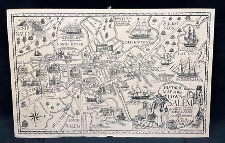
3 days LeftRapid Estate Liquidators and Auction GalleryHistoric Map Of The Town Of Salem Print Copyright John T. NortheyUS$25
368 Lots AwayPotter & Potter AuctionsLISTER, James Wren (1897 – 1952). Avalon Town / Santa Catal...US$125(2 bids)
369 Lots AwayPotter & Potter AuctionsCrosby Service Pictorial Map of Manhattan (New York City). ...US$250
Jun 07Freeman's | Hindman[MAP]. SARTINE, Antoine Plan de la Barre et du Havre de Charles-Town...1778. RARE REVOLUTIONARY WARUS$1,000(1 bid)
3 mins LeftZikorn Arts & History ObjectsJohn W. Barber: Barber's Illustrated Proverbs, 1856 First EditionUS$120
2 days LeftArt Legacy AuctionsFECHIN NICOLAI IVANOVICH OLD PAINTING SIGNED N FECHIN ??VILLAGE STREET?? POSSIBLY RUSSIAN ARTISTUS$3,900
May 25Aurora Antique Auction House LtdWanli 45 April Jizao town Kubao silver ingots weigh one hundred and twoUS$500
May 25Art Legacy AuctionsFECHIN NICOLAI IVANOVICH OLD PAINTING SIGNED N FECHIN ??VILLAGE STREET?? POSSIBLY RUSSIAN ARTISTUS$3,900


![Les Provinces des Pays-bas Catholiques ou HERMAN MOLL: Details: MOLL, Herman. [Belgium] Les Provinces des Pays-bas Catholiques ou A Most Exact map of Flanders or Austrian Netherlands &c. It comprehends all the Towns, Villages, Abbeys, Monasteries Through](https://p1.liveauctioneers.com/5671/103625/53045138_1_x.jpg?height=310&quality=70&version=1494009518)


![[MAP]. SARTINE, Antoine Plan de la Barre et du Havre de Charles-Town...1778. RARE REVOLUTIONARY WAR (1 of 1)](https://p1.liveauctioneers.com/197/329395/177650540_1_x.jpg?height=282&quality=70&version=1715364962)


