Sold2023TWO ANTIQUE AFRICAN MAPS.Early hand colored engraved map of North Africa by Edward Wells, ca. 1700, “A New Map of the North Part of Antient Africa..” image 14.25” x 19”, overall 22” x 27”.See Sold Price
Sold2023Two Maps, Africa by Eustache Herisson, 1809, World Hemispheres 1832 Reprint after A.H Brue, GermanDescription: An antique Africa map, in French and dated 1809 by Eustache Herisson, and a reprit of an early 19th century map of World Hemispheres by Adrien-Hubert Brue. Type: MapMaterials: PaperMarkinSee Sold Price
Sold2017TWO ANTIQUE MAPSGEOGRAPHICAL AND HISTORIAL MAP OF AFRICA AND CHINA MAP. FOLDS IN BOTHSee Sold Price
Sold2023TWO ANTIQUE MAPS OF CHINA.Two antique maps of China, including Chinae by Abraham Ortelius, 1595, image 14.25” x 18.25”, with map of Eastern Asia, Le table de la region orientale, image 10” x 13.5”.See Sold Price
Sold2021Two Antique African Kuba TextilesTwo Antique African Kuba Textiles, one dyed with twool to achieve a red color. Sizes: 1) 35'' x 27'', 89 x 69 cm (textile); 35.5'' x 27.5'', 90 x 70 cm (stretcher); 2) 33.5'' x 30'', 85 x 76 cm (textiSee Sold Price
Sold2022John SPEED: Two Antique Maps of IrelandTwo framed antique maps of Ireland by John Speed, a well known English cartographers circa 17th century. [Maps: 15" H x 20" W; Frames: 24" H x 28 1/2" W].See Sold Price
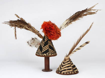
Sold2021Two Antique African Kuba Bushong Ceremonial HeaddressesTwo Antique African Kuba Bushong Ceremonial Headdresses. Each conical basket form with black and white strips. Sizes: 1) 14'' x 14'' x 7'' (36 x 36 x 18 cm); 2)19.5'' x 36'' x 21'' (50 x 91 x 53 cm);See Sold Price
Sold2021Two Antique African SpoonsTwo Antique African Spoons. Carved wood. On stands. Sizes: 1) 14.5'' x 2.5'' x .75'' (37 x 6 x 2 cm); Height on stand: 15.25" (39 cm); 2) 15'' x 2'' x .5'' (38 x 5 x 1 cm); Height on stand: 15.25" (39See Sold Price
Sold2021Two Antique African Benin Ceremonial Swords/EbenTwo Fine African Benin Ceremonial Swords/Eben. Metal, late 19th/early 20th c. On stands. Sizes: 1) 35'' x 7'' x 5.75'' (89 x 18 x 15 cm); Height on Stand: 36" (91 cm); 2) 36'' x 7.5'' x 5.5'' (91 x 19See Sold Price
Sold2021Two Antique African Ivory Turkana Lip Plugsone as necklace with silver bale. Largest: 1" high, 2" diameter. Age cracks. We offer in-house packing and shipping of this item to an address in the United States for $45.00 via USPS Priority Mail. TSee Sold Price
Sold2024Two Antique Maps of the Arabian PeninsulaProperty from the Estate of a Swiss UBS Executive, Zurich and Hilton Head Island, SC Description: Two Antique Maps of the Arabian Peninsula , E. de Wit map of 'New Persia, Armenia, Anatolia and ArSee Sold Price
Sold2023FOUR ANTIQUE AFRICAN MAPS.Four maps including Africae Descripto by Gerard Mercator 6” x 7.75”, Kupferstich-Karte, Rivière de Congo 8.5” x 6.25”, map from the Point of East Tartarty to the Cape of GooSee Sold Price
Sold2021Two Antique Maps of New OrleansTwo Antique Maps of New Orleans , incl. "Plan of the Property belonging to the Fischer Lumber & Mfg. Co., Ltd", 1900, 34 in. x 25 in.; and "Plan of Fbg. (Faubourg) St. Joseph", 10 1/4 in. x 55 inSee Sold Price
Sold2023Collection of David Birney: Two Antique Mapseach: etching; the first: "Ireland from the Best Authorities", frame: 13 1/2 x 14 in. (34.3 x 35.6 cm.); the second: "Lutetia vulgo Paris Anno 1575" (reproduction), frame 18 x 24 in. (45.7 x 61 cm.);See Sold Price
Sold2017Two Antique Maps Chili (sic) & Caribbean C. 16671) "Chili" (Chile), no publishers information, sight size 14.25" x 11.5", by Montanus A., C. 1670. (together with) 2) "Isles D'Amerique dites Caribes ov Cannibales et de Barlovento, by P. du Val d'abbSee Sold Price
Sold2021Two Antique African Ritual Clay Pots, CameroonTwo Antique African Ritual Clay Pots, Cameroon. On woven plant fiber ring-shaped stands. Sizes: 1) 6'' x 10'' x 8'' (15 x 25 x 20 cm); Height on Base: 7.5" (19 cm); 2) 7'' x 9.5'' x 8'' (18 x 24 x 20See Sold Price
Sold2018Two Antique MapsMap of Northern Hemisphere: Carte Des Nouvelles Decouvertes Au Nord De La Mer Du Sud, 18" x 24 1/2" (sight) Francois Santini, Venice and Map Of North America: Nuove Scoperte De' Russi, 12" x 15 3/4" (See Sold Price
Sold2021Two Antique African Neckrests and Stool (3)Two Antique African Neckrests and Stool (3). Carved wood. Sizes: 1) 3.25'' x 19.5'' x 7.25'' (8 x 50 x 18 cm); 2) 6.5'' x 8.5'' x 7.5'' (17 x 22 x 19 cm); 3) 8'' x 8'' x 2.5'' (20 x 20 x 6 cm). Ex. CaSee Sold Price
Sold2021Two Antique African Kuba Shoowa Prestige ClothsTwo Antique African Kuba Shoowa Prestige Cloths. Balanced plain weave, cut pile and stem-stitch embroidery. Sizes: 1) 23'' x 16'', 58 x 41 cm (textile); 25'' x 18.5'', 64 x 47 cm (stretcher); 2) 29.5'See Sold Price
Sold2019Two Antique MapsTwo Antique Maps. Map of United States and Texas, dated 1839 by Daniel Burgess and a Map of Mexico Central America and the West Indies, dated 1867 by S Augustus Mitchell.See Sold Price
Sold2022Two Antique African Metal Currency Axes, NigeriaTwo Antique Metal African Currency Axes, Nigeria. On stands. Sizes: 1) 15'' x 7.25'' x 1'' (38 x 18 x 3 cm); Height on Stand: 15.25" (39 cm); 2) 15'' x 14'' x .5'' (38 x 36 x 1 cm); Height on Stand: 1See Sold Price
Sold2023Two Antique Maps of Indian Territories British America Far WestTwo Antique Maps of Indian Territories British America Far West MEDIUM: Published Printing DIMENSIONS: Framed 18 x 27 inches DESCRIPTION: These early antique maps of British America show Districts, InSee Sold Price
Sold2017Two Antique African Washboards, African FormThis is a lot of 2 lovely old hand carved Washboards from the Dogon peoples, Mali, Africa. Such objects were used for decades , even centuries, showing obvious age and use, it could very well be a latSee Sold Price
5 days LeftJasper521600 GEOGRAPHICAL HISTORIE OF AFRICA antique by JOANNES LEO AFRICANUS 16th cent.US$1,900
5 days LeftJasper521804 TRAVELS of Ledyard & Lucas in Africa antique w/ MAPS Voyages de MM. LédyardUS$240
1 day LeftTrillium Antique Prints & Rare BooksOriginal Chinese Watercolor of Shoebutton ArdisiaUS$500
6 days LeftJasper52SCANDINAVIA. Norway Sweden. Baltic. Christiania/Oslo Bergen Stockholm 1920 mapUS$20
6 days LeftJasper52EUROPE RAILWAYS. double & single track. Narrow gauge. Steamship routes 1920 mapUS$20
6 days LeftJasper52CZECHOSLOVAKIA. w/ Carpathian Ruthenia. Prague/Praha. Bohemia Moravia 1920 mapUS$25
6 days LeftJasper52WORLD WAR 2. Siegfried & Maginot lines defences. Pre-invasion. Belgium 1940 mapUS$25
6 days LeftJasper52WORLD WAR 2. Maginot & Siegfried lines defences. Pre-invasion. Belgium 1940 mapUS$25
6 days LeftJasper52SCANDINAVIA.Shows early railways inc Oslo-Eidsvoll.Norway Sweden.LOWRY 1863 mapUS$25
6 days LeftJasper52WORLD WAR 2. Maginot & Siegfried line defences. Pre-invasion of France 1940 mapUS$25
6 days LeftJasper52WORLD WAR 2. Netherlands & Belgium defences. Maginot & Siegfried lines 1940 mapUS$30
6 days LeftJasper52WORLD WAR 2. Siegfried & Maginot line defences. Pre-invasion of France 1940 mapUS$30
6 days LeftJasper52WORLD WAR 2. Netherlands & Belgium defences. Siegfried & Maginot lines 1940 mapUS$35
6 days LeftJasper521940 EUROPE. WW2.Belligerents/Neutrals Occupied Poland/Finland Albania 1940 mapUS$40


![John SPEED: Two Antique Maps of Ireland: Two framed antique maps of Ireland by John Speed, a well known English cartographers circa 17th century. [Maps: 15" H x 20" W; Frames: 24" H x 28 1/2" W].](https://p1.liveauctioneers.com/1221/264089/138965458_1_x.jpg?height=310&quality=70&version=1667576821)