Sold2022Uncommon Texas/Indian Territory RR map, 1890Unusual map of Texas and Indian Territory by McNally showing highly detailed picture of Native American tribe locations in Indian Territory. Presents a thorough overview of railroad lines in the regioSee Sold Price
Sold20211847 map showing east Texas/Indian TerritoryInteresting map of the southern U. S. in 1847. Map by Cady & Burgess from Roswell SmithÂ’s 1847 Quarto Atlas. Eastern portion of Texas shown along with most of Indian Territory. Also includes ArkanSee Sold Price
Sold20171882 Historical Hand Atlas, H. H. Hardesty Map1882 Historical Hand Atlas Illustrated, H. H. Hardesty 11.5 X 15. This Hard-to-find Atlas Has Been Rebound—it Will Look Great on Your Shelf. Several State Maps (texas/indian Territory, California/laSee Sold Price
Sold20211876 RR map - NE U.S. in uncommon formatLarge and uncommon map of the upper eastern seaboard of the United States in an unusual layout. From the very scarce 1876 Jones and Hamilton Historical Atlas of the World Illustrated. Clean and soundSee Sold Price
Sold20211869 McNally Map of Texas, Indian Territory and NewTitle: 1869 McNally Map of Texas, Indian Territory and New Mexico -- Texas, New Mexico, and Indian Territory Cartographer: F McNally Year / Place: 1869, New York Map Dimension (in.): 8.3 X 10.6 in. ThSee Sold Price
Sold2017Fullarton: Antique Map of Texas & Indian Territory 1860Map: 1860 Fullarton Map of Texas (East/Central), Indian Territory, Louisiana and Arkansas -- United States North America According to Calvin Smith& Tanner . . . South Central Section. Comprising TexasSee Sold Price
Sold2017Cram: Antique Map of Texas, Indian Territory, ArkansasTitle/Content of Map: 1885 Cram Map of Texas, [verso] Indian Territory and Arkansas -- Texas, [verso] Indian Ty; Arkansas Date Printed: 1885, Chicago Cartographer: G Cram Size: 12 x 17 in. This is a nSee Sold Price
Sold2017Rand McNally: Antique Map of Texas & Indian TerritoryMap: 1895 Rand McNally Map of Texas and Indian Territory/Oklahoma -- Texas; Oklahoma and Indian Territory Cartographer: Rand McNally Year / Place: 1895 Chicago Map Dimensions: 9.2 x 12.5 in. ConditionSee Sold Price
Sold2017Rand McNally: Antique Map of Texas & Indian TerritoryTitle/Content of Map: 1895 Rand McNally Map of Texas and Indian Territory/Oklahoma -- Texas; Oklahoma and Indian Territory Date Printed: 1895 Chicago Cartographer: Rand McNally Size: 9.2 x 12.5 in. CoSee Sold Price
Sold2022Maps of North America Atlas of The World 1890-1920Featured in this lot is this Maps of North America and Atlas of the World maps with territories, circa 1890-1920. There are a total of 23 maps, some show two sides and others are single sided. The firSee Sold Price
Sold20181890 Census Office Map of Indian Territory and OklahomaTitle/Content of Map: 1890 Census Office Map of Indian Territory and Oklahoma -- Map of Indian Territory and Oklahoma Date: 1890, Washington Cartographer: General Land Office / Census Office Size: 22.See Sold Price
Sold2022Rare Walling's RR map of Upper Mississippi, 1868This rare map of the mid-continent is most noteworthy for its unusual configuration of Dakota Territory, pre-dating the formation of Wyoming. The map includes early appearances of Colorado Territory aSee Sold Price
Sold2022Scarce 1st ed. Northern Texas/Indian Territory, Tunison 1885Beautiful and scarce double-page chromolithographic map of Northern Texas and Indian Territory. From the 1885 edition of Tunison’s Peerless Universal Atlas of the World. WorldCat lists this atlaSee Sold Price
Sold2022Scarce and impressive early Cram RR map of DakotaVery scarce double-page map of the Dakota Territory from the scarce 1882 edition of Cram’s Unrivaled Family Atlas of the World. The 1882 atlas was the last Cram atlas to feature hand coloring oSee Sold Price
Sold2021Scarce RR map of Wisconsin, 1875Uncommon and large map of Wisconsin found only in the Wisconsin edition of the very scarce Jones and Hamilton Atlas of the World Illustrated, published 1875 by H. H. Hardesty. Huge top and bottom margSee Sold Price
Sold2022Vintage tri-fold RR map of California and NevadaUncommon tri-fold format map of turn-of-the-century California and Nevada with inset of Hawaiian Islands. Highly detailed map shows rail lines in both states. Shows major topographical features, coastSee Sold Price
Sold2022Nice vintage tri-fold RR map of NebraskaUncommon tri-fold map of Nebraska showing an impressive rail system throughout the state at the turn-of-the-century. Color coded by county with color by hachures. Copyright date of 1898 and from an atSee Sold Price
Sold2022Uncommon Hardesty map of upper Northwest US, 1875Nice, elusive early map of northwest territories with vintage original full hand coloring. Idaho and Washington still seen as Territories. ?Map of Washington Oregon and Idaho? published 1875 by HigginSee Sold Price
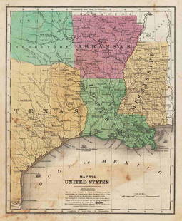
Sold2022Map of Texas, Indian Terr., Mississippi, etc.- OlneyNice hand-colored school atlas map of the near Southwest. “No. 8 Mississippi, Arkansas, Louisiana, Texas, Indian Territory.” From Olney’s 1849 school atlas. Clean with a tiny spot iSee Sold Price
Sold2023Civil War era 1863 map of Mexico & Caribbean nationsLovely and vintage double-page map showing all of Mexico, Central America, Texas, Indian Territory and states of the Deep South during the middle of the American Civil War. Map has an 1860 copyright bSee Sold Price
Sold2016Map of Indian Territory and Oklahoma, J. Bein 1890Title: Map of Indian Territory and Oklahoma Subject: Oklahoma Maker: J. Bein Date: 1890, New York Size: 22.5 x 29.5 inches Map of the Indian Territory showing areas ceded to various tribes, each withSee Sold Price
Sold2022Uncommon map of Oklahoma & Indian Terr., 1897Unusual wax engraved map of Oklahoma Territory/Indian Territory ten years before the region achieved statehood. Numerous Indian nations located throughout. Shows railroads with routes named, towns, riSee Sold Price
Sold2019AN ANTIQUE MAP, "Map of Oklahoma and Indian Territory,"AN ANTIQUE MAP, "Map of Oklahoma and Indian Territory," 1890-1892, color engraving on paper, copyrighted by Mast, Crowell & Kirkpatrick, with view of Beaver. 10.375" x 13" Note: Showing populations oSee Sold Price
Sold20221874 map of Western states & territories, MitchellInteresting and uncommon variant transitional issue that appeared in only a few editions of Mitchell’s New General Atlas. Fine 19th century engraved (lithographed) map, with original hand color. ShoSee Sold Price
Jun 12Dan Morphy AuctionsPLATE CXIII. MAP OF INDIAN TERRITORY SHOWING DISTRIBUTION OF WOODLAND” FROM THE TWENTY-FIRSTUS$100
8 hrs LeftJasper52Central Europe. Germany Poland Czechoslovakia Carpathian Ruthenia TIMES 1922 mapUS$30
23 hrs LeftPotter & Potter Auctions[NEW YORK CITY – PICTORIAL MAPS]. Group of 3 pictorial maps...US$200(1 bid)
8 hrs LeftJasper52YUGOSLAVIA. Trieste international zone. Slovenian Istria. BARTHOLOMEW 1947 mapUS$30
Jun 12Dan Morphy AuctionsMAP OF THE CHOCTAW NATION, INDIAN TERRITORY - COAL AND ASPHALT SEGREGATION 1903US$150
23 hrs LeftPotter & Potter AuctionsSTORM, Mark. Official Texas Brags Map of North America. 194...US$200(1 bid)
Featured8 hrs LeftJasper52Europe after the Congress of Vienna. 4 sheets. 128x106cm. THOMSON 1817 old mapUS$550
Jun 12Dan Morphy AuctionsBRUE'S MONUMENTAL WALL MAP OF TEXAS, UPPER CALIFORNIA & MEXICO, C. 1845US$500
23 hrs LeftPotter & Potter AuctionsTerritory of Alaska / Alaska Steamship Company. 1936. Seatt...US$100
Jun 29JM Hobby Supply and Railroad Artifact AuctionsFlorence & Cripple Creek RR Public Timetable-September 1894US$400
Jun 29JM Hobby Supply and Railroad Artifact AuctionsSanta Fe RR Adlake Round Top Post Mount Switch LanternUS$100(1 bid)
8 hrs LeftJasper52OTTOMAN EMPIRE in Europe & Asia. Greece. British Ionian Islands. SDUK 1844 mapUS$65
Jun 23Schilb Antiquarian Rare Books1890 Livingstone 1ed In Darkest Africa Henry Stanley Emin Pasha Expedition MAPUS$1
Featured8 hrs LeftJasper52BALKANS. Pannonie/Pannonia Illyria. Croatia Bosnia Serbia. MALLET 1683 old mapUS$40
6 days LeftJasper521878 Mitchell Map of Washington, Oregon, Idaho, much of Montana [verso] Territory of IdahoUS$55
Featured6 days LeftJasper52Johnson's New Military Map of the United States Showing the Forts, Military Posts &C. With EnlargedUS$65
May 31Freeman's | Hindman[NATIVE AMERICAN]. RANDALL, A. F. (1854-1916), photographer. Boudoir card featuring Apache subjectsUS$200


![Cram: Antique Map of Texas, Indian Territory, Arkansas: Title/Content of Map: 1885 Cram Map of Texas, [verso] Indian Territory and Arkansas -- Texas, [verso] Indian Ty; Arkansas Date Printed: 1885, Chicago Cartographer: G Cram Size: 12 x 17 in. This is a n](https://p1.liveauctioneers.com/5584/113749/58452563_1_x.jpg?height=310&quality=70&version=1513734097)


![[NEW YORK CITY – PICTORIAL MAPS]. Group of 3 pictorial maps... (1 of 3)](https://p1.liveauctioneers.com/928/325952/175495562_1_x.jpg?height=282&quality=70&version=1712935174)


![1878 Mitchell Map of Washington, Oregon, Idaho, much of Montana [verso] Territory of Idaho (1 of 2)](https://p1.liveauctioneers.com/5584/329422/177662232_1_x.jpg?height=282&quality=70&version=1715717898)

![[NATIVE AMERICAN]. RANDALL, A. F. (1854-1916), photographer. Boudoir card featuring Apache subjects (1 of 2)](https://p1.liveauctioneers.com/197/329785/177758596_1_x.jpg?height=282&quality=70&version=1715625218)