Sold2018United States North America... the South Eastern StatesTitle/Content of Map: United States North America... the South Eastern States Comprising... Date Printed: 1854 Cartographer: SWANSTON, G.H. Size: 15.3X19.5 Best atlas map of period for placenames.PastSee Sold Price
Sold2018United States of North America: South EasternTitle/Content of Map: United States of North America: (South Eastern Division) the Southern States Date Printed: c1885 Cartographer: PHILIP, GEORGE & SON Size: 19.6X23.75 Printed 56-page index insideSee Sold Price
Sold2022Native American Stone Full Groove Axe HeadNative American, North America, southeastern United States, Eastern Woodland culture, ca. 500 to 1500 CE. A sturdy hand axe that is carved from mottled beige stone with green, dark gray, citrine, andSee Sold Price
Sold2017Native American Stone Discoidal - Woodlands Period**First Time At Auction** Native American, North America, southeastern United States, Woodlands period, ca. 500 to 1500 CE. An interesting and well-used discoidal carved from a mottled brown, orange,See Sold Price
Sold2017Native American Bannerstone - Little Tennessee River**First Time At Auction** North America, Southeastern United States, Little Tennessee River, Mississippian culture, Archaic Period, ca. 8000 to 5000 BCE. A brown-hued bannerstone, a weight for an atlaSee Sold Price
Sold202320th C. American Pine Needle & Raffia Folk Art Baskets**Originally Listed At $400** North America, Southeastern United States, ca. late 20th century CE. This is a fine trio of 3 hand-woven baskets and trays made of raffia and pine needles that demonstratSee Sold Price
Sold2018Mississippian Pottery Burial Urn for Infant**First Time At Auction** North America, probably southeastern United States, Late Mississippian period, ca. 1400 to 1700 CE. A large hand-built terracotta vessel with a rounded base, smooth exteriorSee Sold Price
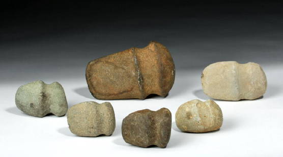
Sold2018Lot of 6 Native American Stone Axes - Mississippian**First Time At Auction** North America, southeastern/midwestern United States, Mississippian culture, ca. 1000 to 1500 CE. A lovely set of six heavy stone hand axes, hand-knapped and smoothed from aSee Sold Price
2018Ettling: Antique Map of USA SOUTH EAST, 1863TITLE/CONTENT OF MAP: 'United States of North America (Eastern & central)' USA SOUTH EAST. Florida Georgia Carolina coast Bahamas DATE PRINTED: 1863 IMAGE SIZE: Approx 44.5 x 32.0cm, 17.5 x 12.5 incheSee Sold Price
Sold2017Large Native American Full-Grooved Stone Axe**First Time At Auction** North America, modern-day southeastern/midwestern United States, Mississippian culture, ca. 1000 to 1500 CE. A large, heavy, grooved stone axe, hand-knapped and smoothed fromSee Sold Price
Sold2016Rare, McLoughlin War at Sea GameOne of McLoughlin's biggest games, and great chromolithography on the box cover. The board depicts the ocean just north of South America and up the Eastern Coast of the United States. The built up boaSee Sold Price
Sold2022AN AMERICAN CIVIL WAR ERA MAP, "United States of North America (Eastern & Central)," LONDON,AN AMERICAN CIVIL WAR ERA MAP, "United States of North America (Eastern & Central)," LONDON, 1861-1873, THEODORE ETTLING (b. 1823), hand colored lithograph on paper, by T. Ettling, published by CasselSee Sold Price
Sold2020CIVIL WAR USA showing Union Confederate & BorderTITLE/CONTENT OF MAP: 'United States of North America (Eastern & central)' The map depicts the United States as divided in the early part of the Civil War between the Union states, the Confederate staSee Sold Price
Sold20211860 Ettling Map of United States -- United States ofTitle: 1860 Ettling Map of United States -- United States of North America (Eastern & Central) Cartographer: T Ettling Year / Place: 1860 c., London Map Dimension (in.): 33.5 X 35.5 in. joined This isSee Sold Price
Sold202220th C. Amish Wood Painted Barn Panels, Raindrop Hex**Originally Listed At $500** **This is an oversized piece that may require special shipping. Please inquire for a quote prior to bidding. North America, Eastern United States, Pennsylvania, Amish, caSee Sold Price
Sold2017Ettling: Map of United States of North America, 1860United States of North America (Eastern & Central) T. J. Ettling, c1860 17 x 25. This great Civil War era map covers the country from the Rocky Mountains to the Atlantic seaboard. The map is engravedSee Sold Price
Sold2022Large Fossilized Ammonite Placenticeras Meeki in MatrixNorth America, United States, South Dakota, Pennington County, Cheyenne River, Pierre Shale Formation, Lower Cretaceous, 100.5 to 66 million years ago. A superb, fossilized ammonite of the PlacenticerSee Sold Price
Sold2015Revolutionary War Era Hand-Forged Iron Pike HeadNorth America, United States, Eastern Seaboard, ca. 18th century CE. A rare hand-forged iron pike head with a folded shaft and tapered blade, created and used during the Revolutionary War era. PerforaSee Sold Price
Sold202018th C. American Iron Naval Pike HeadNorth America, United States, Eastern Seaboard, ca. 1775 to 1800 CE. A rare hand-forged iron pike head with a folded shaft, tapered blade, three-tiered rounded decorative ornament where the blade inseSee Sold Price
Sold2015Revolutionary War Iron Pike, Bronze AdornmentNorth America, United States, Eastern Seaboard, ca. 1760 to 1780. An imposing iron pike / spontoon with a large folded shaft and tapered blade with added bronze decorative attachment where blade insetSee Sold Price
Sold2021Native American Stone Discoidal - Rare SizeNorth America, Midwest / Eastern United States, Late Prehistoric Mississippian culture, ca. 1350 to 1700 CE. A remarkable granite stone fashioned and sanded into a smooth, round-edged disc (discoidal)See Sold Price
Sold2021Native American Mississippian Stone DiscoidalNorth America, Midwest / Eastern United States, Late Prehistoric Mississippian culture, ca. 1350 to 1700 CE. A remarkable granite stone fashioned and sanded into a smooth, round-edged disc (discoidal)See Sold Price
Sold2018Ettling: Antique Map of USA NORTH EAST, 1863TITLE/CONTENT OF MAP: 'United States of North America North Eastern sheet' New England & Mid-Atlantic states. DATE PRINTED: 1863 IMAGE SIZE: Approx 45.5 x 33.0cm, 17.75 x 13 inches (Large) TYPE: AntiqSee Sold Price
Sold2018Ancient Mississippian Bannerstone Atlatl Weight**Originally Listed At $300** North American, southeastern United States, Mississippian, Archaic Period, ca. 8000 to 5000 BCE. A fine example of a pretty greenstone bannerstone, a weight for an atlatlSee Sold Price
3 days LeftJasper52New Map of That Portion of North America Exhibiting the United States and Territories...Mexico...US$360
May 16Potter & Potter AuctionsSTORM, Mark. Official Texas Brags Map of North America. 194...US$200(1 bid)
13 hrs LeftKCM GalleriesLarge Detailed Original Oil Painting United States Map Julius Lira Salazar 48 x 36 inchesUS$1,800
May 05KCM GalleriesLarge Detailed Original Oil Painting United States Map Julius Lira Salazar 48 x 36 inchesUS$1,800