Sold2017Very Large German Military Map of the Italian BombingsVery Large German Military Map of the Italian Bombings of Africa and the Middle East, including the Bombing of Haifa in 1940 - Extremely Rare! A. Very large German map of the Italian bombings of AfricSee Sold Price
Sold2022FALL OF FRANCE 1940. German British French Belgian troop positions 1953 mapTITLE/CONTENT OF MAP: 'Stellungskarte West' DATE PRINTED: 1953 IMAGE SIZE: Approx 42.5 x 54.5cm, 16.75 x 21.5 inches (Large); Please note that this is a folding map. TYPE: Vintage military map CONDITISee Sold Price
Sold2020WEHRMACHT 1940 -A YEARBOOK OF THE WAR FOR THE YEAR 1940German military annual books - 1940 (covering 1.September.1939 to 31.August.1040 ) The book is hardback and has a total of 320 numbered pages. Large number of photos and a large pull out map in the baSee Sold Price
Sold20221918 WWI FRAMED GERMAN MILITARY MAPWORLD WAR ONE BATTLE OF VERDUN FRAMED MILITARY MAP. CREASES AND STAINS. 21" x 20" MAP SIZE / 29" x 29" IN FRAME.See Sold Price
Sold2023WWII German Invasion of England 2nd Ed. MapsWorld War 2 german military plan maps of london, england invasion. 2nd edition, 1941. Includes 5 maps and folder. All maps are in tact, some yellowing and minor wear to fold creases due to age.See Sold Price
2020Original WWII German Military Large Inflatable RaftOriginal WWII German Military Large Inflatable Raft - Offered Without Reserve - There is NO ESTIMATE on this item. - Vintage Original WWII German Military Large Inflatable Raft - LOCAL PICK UP ONLYSee Sold Price
Sold2018ANTIQUE ITALIAN MILITARY MAP HANDKERCHIEF C 1884An antique Italian handkerchief printed with Military Circumscriptions of Italy, dated 1884. Color border. Visible part of handkerchief measures 20.25" tall x 23" wide. Frame measures 24.25" tall x 27See Sold Price
Sold2020Large All in German MAP ATLAS Diercke Schulatlas....Large All in German Diercke Schulatlas Für Höhere Lehranstalten; Grosze Ausgabe ATLAS in Acceptable Conditon as Pictured. A Ton of Maps. FREE DOMESTIC SHIPPING!See Sold Price
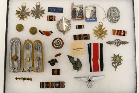
Sold2020WWII German Military LotNice large lot of German military items. Lot includes shoulder boards, pins, stickpins, medals, badges, and more. Largest piece measures approximately 3 3/4'' long by 1 1/2" wideSee Sold Price
Sold2016WWII German Pins/Badges (19)Large assortment of German military and political pins/badges, also includes 2" x 1.5" Des Fuhrers Kampf in Norwegenbook, marked vom 9. April bis 10. Juni 1940See Sold Price
Sold2022SEVEN ENGRAVED MAPS.European, 18th-19th century. Printed with some hand coloring. Four on laid paper including three German and French military maps, "Plan des Camps de Pisek, 1741", 15.25"h. 20.25"w., battles of PeterwaSee Sold Price
Sold2021LARGE ANTIQUE ITALIAN MAPLarge Antique Italian Map on grey fabric. Size: 31 X 29.5 Inches Approximately. Printed Circa 1882. Unframed.See Sold Price
Sold2021LARGE ANTIQUE ITALIAN MAPLarge Antique Italian Map on grey fabric. Size: 31 X 29.5 Inches Approximately. Printed Circa 1882. Unframed.See Sold Price
Sold2021LARGE ANTIQUE ITALIAN MAPLarge Antique Italian Map. Size: 32 X 29.5 Inches Approximately. Printed Circa 1882. Unframed.See Sold Price
Sold2021LARGE ANTIQUE ITALIAN MAPLarge Antique Italian Map. Size: 32 X 29.5 Inches Approximately. Printed Circa 1882. Unframed.See Sold Price
Sold2021LARGE ANTIQUE ITALIAN MAPLarge Antique Italian Map on grey fabric. Size: 31 X 29.5 Inches Approximately. Printed Circa 1882. Unframed.See Sold Price
Sold2021LARGE ANTIQUE ITALIAN MAPLarge Antique Italian Map on grey fabric. Size: 31 X 29.5 Inches Approximately. Printed Circa 1882. Unframed.See Sold Price
Sold2021LARGE ANTIQUE ITALIAN MAPLarge Antique Italian Map on grey fabric. Size: 31 X 29.5 Inches Approximately. Printed Circa 1882. Unframed.See Sold Price
Sold2021LARGE ANTIQUE ITALIAN MAPLarge Antique Italian Map. Size: 32 X 29.5 Inches Approximately. Printed Circa 1882. Unframed.See Sold Price
Sold2022Large Antique French map GERMAN EMPIRE 1792 colored by POIRSON engraver BassetJean-Baptiste Poirson is an engineer-geographer and cartographer. Born in Vrécourt (Vosges) on March 6, 1761, he studied mathematics, geography and followed an engineering career. Under the direcSee Sold Price
Sold2024Flemming, Carl C1890 Large Map of Africa. German Colonial MapLarge Lithograph Map Published C1890, Glogau, Poland. Published for Carl Flemming's Generalkarten Series, No.43. Neatly Linen backed. Paper Size: 32.5 x 27.5 inch (83 x 70cm) Minor blue crayon marks iSee Sold Price
Sold2020TRUSSARDI Military Style Italian Large Shoulder BagTRUSSARDI Military Style Italian Large Shoulder Bag Never Used Approximately 17” x 22” without handles.See Sold Price
Sold2020Large lot of pinbacks - including German militaryLarge lot of pinbacks - including German militarySee Sold Price
Sold2021Large lot foreign currency, post WW1 German, Italian,Large lot foreign currency, post WW1 German, Italian, Romanian, a large selection of various Post World War 1 currency, & select coinageSee Sold Price
3 days LeftTrillium Antique Prints & Rare BooksDe Jode, Rare, pub. 1593 - Map of Kingdom of Napoli, Italy (Neapolitani Regni exacta ac diligensUS$130(3 bids)
3 days LeftTrillium Antique Prints & Rare BooksDe Jode, Rare, pub. 1593 - Map of Hainut, Belgium (Hannoniae Comitatus Descriptio)US$100(1 bid)
208 Lots AwayJasper52Home Waters. Blockade of Germany. Minefields. 1914. First World War. 1920 mapUS$20
2024Jasper52L'Allemagne, La Boheme, et La Hongrie; avec…partie de Pologne. BONNE 1780 mapSee Sold Price
2024Jasper52The "Silent [Zeppelin airship] raid" on the night of 19-20th Oct 1917 1925 mapSee Sold Price
10 hrs LeftHermann Historica GmbHA German or Italian rapier of Pappenheim type with Piccinino blade, circa 1620€4,000
2024Jasper52German invasion of Belgium and France, May-June 1940. World War 2 1953 old mapSee Sold Price
216 Lots AwayJasper52Battle of Jutland. First of June 1916. First World War. 1923 old antique mapUS$20
207 Lots AwayJasper52Battle of Jutland. Night Actions 31 May 1916. First World War. 1923 old mapUS$20
7 days LeftJasper52Burma & Malaya 1943-44. Japanese & Allied airfields. Indochina Siam WW2 1961 mapUS$25
211 Lots AwayJasper52Battle of Heligoland Bight, 28th August 1914, First World War. 1920 old mapUS$30
2024Jasper52Operation Dragoon 15 August 1944. Assault. Invasion of South of France 1961 mapSee Sold Price
267 Lots AwayJasper52Pursuit of SMS Goeben & Breslau. 3-5th August 1914. First World War. 1920 mapUS$25
2024Jasper52Raid on the Yorkshire Coast 16th December 1914. Tactical plan. WW1. 1921 mapSee Sold Price
2024Jasper52Bombardment of Yarmouth & Lowestoft. 25th April, 1916. Tactical plan 1923 mapSee Sold Price


![The "Silent [Zeppelin airship] raid" on the night of 19-20th Oct 1917 1925 map (1 of 1)](https://p1.liveauctioneers.com/5584/328641/177014282_1_x.jpg?height=282&quality=70&version=1715113718)


