Sold2022Vintage Berchtesgadener Land Municipality Map of GermanVintage Berchtesgadener Land Municipality Map of German 27.5x21See Sold Price
Sold2018Large Ortelius Abrahami Patriar Holy Land MapVery Large Ortelius Abrahami Patriar Holy Land Map Vintage Reproduction Abrahami Patriarchae Peregrinatio, et Vita" Abraham OrteliusThis is a vintage reproduction of the most beautiful Holy Land mapsSee Sold Price
Sold2017VINTAGE HAND MADE LAND PLOTS MAP 1816Property of Elijah Purdy , The town of White Plains, October 8th 1816. Dimensions: (framed) H 10" x W 12.5" (sight) H 7.75" x W 8" Condition: some small folds and tears, little water damage on the lefSee Sold Price
Sold2019Lot of Vintage Ephemera , Many German MapsLot of Vintage Ephemera , Many German MapsSee Sold Price
Sold2020c1920s WESTGATE DISTRICT Columbus OH HOUSINGc1920s WESTGATE DISTRICT Columbus OH HOUSING DEVELOPMENT PLAN TROLLEY SUBURB MAP c1920s WESTGATE DISTRICT Columbus OH HOUSING DEVELOPMENT PLAN TROLLEY SUBURB MAP Circa 1920s Vintage Land Development PSee Sold Price
Sold2023Antique German Map of the Holy LandGerman, circa 1730, hand-colored engraving on paper depicting the path of the Children of Israel after their escape from Egypt, 16 1/2" x 20 1/2" sheet size, 21" x 24 1/2" mat size.See Sold Price
Sold2024Vintage 1955 German Leather Map CaseTan toned leather map case with shoulder strap and button snap top flap and side clip. Folds out to the side with plastic interior to keep papers and map within. Marked on interior. 1955. Approx 9.5 xSee Sold Price
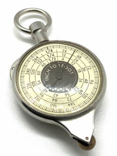
Sold2020Vintage German OPISOMETER, Precision Map MeasurerA vintage German Opisometer. Also called a curvimeter, meliograph, or map measurer. This tool is used to measure the lengths of curved lines. The piece has two faces, one reading ‘ inch to 1 foot ��See Sold Price
Sold2022Vintage Topography Map of Wasatch National Park UtahVintage Topography Map of Wasatch National Park Utah This is a vintage map from a land survey from 1885. This is old Salt Lake Utah with National Forests. This is called a Reconnaissance map. This mapSee Sold Price
Sold2021Terra Sancta Holy Land Map with the Borders of the 12Terra Sancta Holy Land Map with the Borders of the 12 Tribes of Israel, Nuremberg, 1707. Johann Baptista Homann (German, 1664-1724). Title: Iudaea seu Palaestina ob sacratissima Redemtoris vestigia hoSee Sold Price
Sold2022Early 18th cent Holy Land Map of JerusalemVisscher, after Nicolaum (Nicolaes) (Dutch, 1618-1679), Die Heylige und Weitberuhmte Stadt Jerusalem Erstlich Genant Salem, antique map, c. 1710s, published in a German bible by Johann Detleffsen, a sSee Sold Price
Sold2022Early 18th cent Holy Land Map of Middle EastVesscher, after, Die Gelegenheit des Paradeis und des Lands Canaan, Sambt den Erst Bewohnten Landeren der Patriarchen..., antique map, c. 1710s, published in a German bible by Johann Detleffsen, a sliSee Sold Price
Sold2022Giant Vintage Hangable Map for The Land of Israel Schools Edited by Moshe Brawer Published by YavnehGiant Vintage Hangable Map for The Land of Israel Schools Edited by Moshe Brawer Published by Yavneh - designated for schools or public institution. Scale 1:300.000, includes two scaled maps: a politiSee Sold Price
Sold2022Abraham Ortelius and Theodore de Bry, Two Vintage MapsABRAHAM ORTELIUS and THEODORE DE BRY (Belgian, 1527-1598), (German, 1528 - 1598), Maris Pacifici quod vulgo Mar del Zud, 1601, and Hispaniae Novae Sive Magnae, Recens et Vera Descriptio, 1595, two vinSee Sold Price
Sold2022Two Vintage Maps, Candia and SibiniumGEORG BRAUN and FRANS HOGENBERG (German 1541-1622), and (Flemish, 1540-1590), Candia [and] La Cita De Corphu, 1590, and (Sibernik, Porec and Modon) Sibinium, Ptolemeo Sicum vulgo Sibenicho. Dalmatie OSee Sold Price
Sold2022FALL OF FRANCE 1940. German British French Belgian troop positions 1953 mapTITLE/CONTENT OF MAP: 'Stellungskarte West' DATE PRINTED: 1953 IMAGE SIZE: Approx 42.5 x 54.5cm, 16.75 x 21.5 inches (Large); Please note that this is a folding map. TYPE: Vintage military map CONDITISee Sold Price
Sold2024SECOND WORLD WAR AFRICA. European colonies & German mandates 1940 old mapTITLE/CONTENT OF MAP: 'Africa: Political, Showing European Partition' DATE PRINTED: 1940 IMAGE SIZE: Approx 27.0 x 22.5cm, 10.5 x 9 inches (Medium) TYPE: Vintage colour map; Scale 1:35,000,000 CONDITISee Sold Price
Sold2023SECOND WORLD WAR AFRICA. European colonies & German mandates 1940 old mapTITLE/CONTENT OF MAP: 'Africa: Political, Showing European Partition' DATE PRINTED: 1940 IMAGE SIZE: Approx 27.0 x 22.5cm, 10.5 x 9 inches (Medium) TYPE: Vintage colour map; Scale 1:35,000,000 CONDITISee Sold Price
Sold2024Pre-SECOND WORLD WAR AFRICA. European colonies & German mandates 1942 old mapTITLE/CONTENT OF MAP: 'Africa: European partition, pre-war' DATE PRINTED: 1942 IMAGE SIZE: Approx 27.5 x 22.5cm, 11 x 9 inches (Large) TYPE: Vintage colour map CONDITION: Good; suitable for framing. HSee Sold Price
Sold2019von Reilly: Gibraltar and Surrounding Spanish LandsCartographer: Franz Johann Joseph von Reilly Place/Date: Vienna / 1789 Size: 10 3/8" x 8 5/8" Condition: wash color; light overall age-toning A beautifully designed and colored German map of GibraltarSee Sold Price
Sold2018Vintage Auto Advertising and Map LotGMC, Gulf, Esso, Shell, Sunoco, Plymouth, 1940 Classical Lands Mediterranean Map, 1939 Atlantic Ocean map, Boston and moreSee Sold Price
Sold2021Sebastian Munster (German, 1488-1552) - Holy Land andSebastian Munster (German, 1488-1552) - Holy Land and Cyprus Map, Woodcut, Circa 1550. Hand colored woodcut. Printed in Basle by Petri. Sheet: 31.5x19.5cm. Plate: 26.5x16.5cm.See Sold Price
Sold20231849 German ATLAS MAPS Heinrich Dittmar Max Frommann Greece Italy Holy Land1849 German ATLAS MAPS Heinrich Dittmar Max Frommann Greece Italy Holy Land An impressive 19th-century German world atlas! This oblong atlas contains 14 stunning maps by Heinrich Dittmar and MaximilliSee Sold Price
Sold2022Vintage Western 1930s Ephemera, MapsStockman-Farmer Company catalogs (8), Saddle & Harness Catalog by Porter, Byers Peak Ranch for Boys pamphlets, 1958 AAA Western tour book, 1967 AAA European Travel Guide, German tour maps (4), ink bloSee Sold Price
3 days LeftPandora AuctionsVintage MAISTO Germany 1959 Cadillac Eldorado Diecast Model Car 1:18 ScaleUS$25(1 bid)
3 days LeftPandora AuctionsRare Vintage HOHNER Germany Sextet 6-Sided Star Shaped HarmonicaUS$85(2 bids)
403 Lots AwayActivity AuctionsOriginal Vintage Poster GERMANY BLACK FOREST German Rail Travel Tourism LINENUS$1,300


![Two Vintage Maps, Candia and Sibinium: GEORG BRAUN and FRANS HOGENBERG (German 1541-1622), and (Flemish, 1540-1590), Candia [and] La Cita De Corphu, 1590, and (Sibernik, Porec and Modon) Sibinium, Ptolemeo Sicum vulgo Sibenicho. Dalmatie O](https://p1.liveauctioneers.com/1098/249667/130502347_1_x.jpg?height=310&quality=70&version=1654872067)


