Sold2020Vintage Denison Dam reservoir area map 1943Vintage Denison Dam reservoir area map 1943See Sold Price
Sold2022Vintage Map; 1943 Banff-Bassano Navigation chart used by members of the Royal Canadian Air Force inVintage Map; 1943 Banff-Bassano Navigation chart used by members of the Royal Canadian Air Force in the area of Calgary. Alberta. Canada.See Sold Price
Sold2020Vintage map of Mediterranean area(?)Vintage map of Mediterranean area(?), 11"x16"See Sold Price
Sold2018Vintage WWII News Map of the Russian Front, 1943Title/Content of Map: Newsmap. Date Printed: 27/09/1943 Cartographer: ANONYMOUS Publisher: ARMY INFORMATION BRANCH 1943-09-27 WASHINGTON, DC Size: Wall - 35"H. x 47"W "211th week of the war. 93rd weekSee Sold Price
Sold2018Vintage Polar Projection of WWII World Pictorial MapTitle/Content of Map: 1943 Alcoa Aluminum Polar Projection of World at World Pictorial Map -- Global Map for Global War and Global Peace Date Printed: 1943 Cartographer: Alcoa Aluminum Co. Size: 24.4See Sold Price
Sold2023Binder full of vintage and antique ephemera - advertisements, map, Chicago area history, etc.Binder full of vintage and antique ephemera - advertisements, map, Chicago area history, etc. Not all pages are shown.See Sold Price
Sold20231940s San Francisco Bay Area Pictorial Map - San Francisco Bay Metropolitan Area - Attached to1940s San Francisco Bay Area Pictorial Map - San Francisco Bay Metropolitan Area - Attached to Poster Board from S.F. Economic Survey 1943 by S.F. Chamber of Commerce 31.5'' x 26''See Sold Price
Sold2019Vintage Road Maps (14)Including 1980-1981 New Jersey map & guide; (3) Somerset & Hunterdon Counties New Jersey map; Burlington Bridges Area Road map; Northern Hunterdon County, NJ map; Sunoco New York map; Texaco Florida,See Sold Price
Sold2024Panama Canal & World Rulers, 1909Heading: (Panama) Author: Title: Topographical relief map of the Panama canal and surrounding territory... showing lock canal as proposed by latest plans, artificial reservoirs, dams, spillways, andSee Sold Price
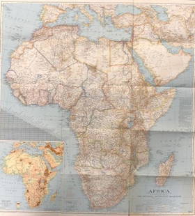
Sold2020Vintage National Geographic Map of AfricaDescription: Vintage color paper map from National Geographic Magazine depicts Africa. Some tearing on bottom. Map is copyrighted from 1943. Material: paper. Measurement: approximate 26.5"h x 34"w (INSee Sold Price
Sold2023Propaganda Poster South America Map Indian Culture Principal TribesOriginal vintage poster featuring a pictorial map of the Areas of Indian Culture and Principal Tribes in South America marked in the geographical and cultural groups of the Antillean, Chibchan, AmazonSee Sold Price
Sold2022Vintage Valentine's, Whiskey, Maps, and MoreVintage Old Woman in the Shoe Valentine in sleeve, six Old Mr Boston Blended Whiskey labels from Boston, Mass, vintage Cram's Street Map of the Baltimore Area, bronze Christmas token dated 1980, threeSee Sold Price
Sold2018Vintage Hearne Brothers Map of Stamford CTVintage Hearne Brothers Polyconic Projection Pulldown Map of Stamford metropolitan area Connecticut. Some creases in map and five small tears to left side. Slight rusting to top metal bracket. MeasureSee Sold Price
Sold2022MAPS, Southwest US, Eddy/CornelySouthwestern United States, Reno. Eddy/Cornely, [Lot of 2] Panoramic Perspective of the Area Adjacent to Boulder Dam as It Will Appear When Lake Is Filled... [and] Reno and the Truckee Meadows, 1938-4See Sold Price
Sold20201943 NY Kaaterskill Quadrangle Geological Survey MapDescription: Vintage 1943 NY Kaaterskill Quadrangle Geological Survey map; reprinted from a 1903 edition. Henry Gannett, Chief topographer, H.M. Wilson, geographer in charge; triangulation by U.S.C.&GSee Sold Price
Sold2024Texaco Metal Brochure Map Rack21" x 22" x 4.75" Metal rack with normal wear throughout, a few small areas of light surface rust. 20 vintage maps included. PLEASE NOTE, THERE IS ONLY ONE WAY TO PAY FOR ONLINE ITEMS IN THIS AUCTIONSee Sold Price
Sold2019Dambusters vintage Daily Telegraph printed Tuesday MayDambusters vintage Daily Telegraph printed Tuesday May 18, 1943 the day after the Dambuster raid on the Mohne Dam. Good Condition. All signed pieces come with a Certificate of Authenticity. We combineSee Sold Price
Sold2017Vintage Pictorial Map of Newport, RI & Ten Mile DriveMap: Pictorial Map of Newport, RI and Ten Mile Drive Maker: Mount Hope Bridge Corporation Publication Date: 1937 Geographic Area: United States Body of Water: Narragansett Bay ConditoiN: Very good. ASee Sold Price
Sold2023ASIA. The Railroads of Asia in 1914 1948 old vintage map plan chartThe Railroads of Asia in 1914' by Drawn by Walter Y. Cox (1948). Vintage map. This map was published in 1948 but it may depict an earlier representation of the area shown dated 1914 and the mapmaker mSee Sold Price
Sold2023VINTAGE CALIFORNIA STATE MAPS / TRAVEL EPHEMERA, UNCOUNTED LOTVINTAGE CALIFORNIA STATE MAPS / TRAVEL EPHEMERA, UNCOUNTED LOT,for the Bay Area, with Conoco and Shell examples.20th century. Provenance: From the Dean and Leann Lindsey collection, Phoenix, AZ.See Sold Price
Sold2021Impressive map of Louisiana, O. W. Gray, 1875Title: Impressive map of Louisiana, O. W. Gray, 1875 Description: Great vintage hand colored map of this beautiful Gulf state. Wonderful detailing of the southern marshy areas along the coast, and nicSee Sold Price
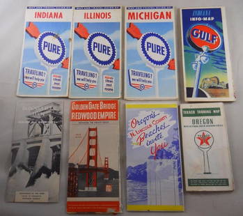
Sold2018Grouping of vintage gas station road maps and travelPure, Gulf, Texaco Maps. Golden Gate Bridge, N. Lincoln, Bonneville Dam – 8 pcs. Total.See Sold Price
2 days LeftJasper52Operation Torch Nov 1942-May 1943. World War 2. Western Mediterranean 1966 mapUS$15
2 days LeftJasper52SOUTHERN AFRICA.Inset Ascension Is.; European colonies 1914;St Helena 1920 mapUS$20
Jun 15Hess Fine AuctionsGuillermo Gomez Gil (1862-1942) Signed Oil on Canvas Painting Flamenco Spanish Guitarist PaintingUS$70(3 bids)
1 day LeftJasper521775-1780 North West Africa with Cape Verde and Canary Islands. By Bonne and RaynalUS$20
1 day LeftJasper521775-1780 North & South Carolina, Georgia and Virginia. By Bonne & RaynalUS$180(2 bids)
6 days LeftThe North Georgia Auction Company LLCClint Alderman Edgefield Area Potteries MapUS$200(1 bid)


![MAPS, Southwest US, Eddy/Cornely: Southwestern United States, Reno. Eddy/Cornely, [Lot of 2] Panoramic Perspective of the Area Adjacent to Boulder Dam as It Will Appear When Lake Is Filled... [and] Reno and the Truckee Meadows, 1938-4](https://p1.liveauctioneers.com/6576/239352/124055616_1_x.jpg?height=310&quality=70&version=1646166282)