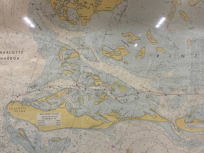
Sold2024Vintage Framed Pine Island & Lacoste Island MapVintage full color paper map, marked on top Pine island, Charlotte harbor and Lacosta island. Showing waterways and directions. Framed in a wooden frame. Approx 14 x 18 inches window measures 11.5 x 1See Sold Price
Sold2023ESTATE OF SEYMOUR STEIN: "A MAP OF LONG ISLAND" FRAMED VINTAGE MAP 22" X 29 1/2" OVERALLESTATE OF SEYMOUR STEIN: "A MAP OF LONG ISLAND" FRAMED VINTAGE MAP 22" X 29 1/2" OVERALLSee Sold Price
Sold2021Vintage Wall Art Maps- World and NewportTwo Vintage Wall Art Maps- World Map printed in 1930's by Hendrik Willem Van Loon and 1957 Newport Rhode Island Map. Both Framed. Measure 23" x 19 1/2" and 23" x 18". Condition: GoodSee Sold Price
Sold2021Two Framed Vintage Maps of NantucketOne is a map of the island, the other a street map with vignettes of historical landmarks. Both published by Mitchell's Book Corner in 1973, both 17H inches x 22W inchesSee Sold Price
Sold2024Map of 1797 Virgin IslandsFramed map of the Virgin Islands in 1797, wooden burl frame. Reproduced from the West India Atlas. Please review all photos for further information & description. All measurements are approximate. MeaSee Sold Price
Sold2018Framed Vintage 1985 Golf Classic Event PosterSea pines Heritage golf classic 1985 , Harbor Town Golf Links Hilton Head Island, April 15-21, measures ht 24 by 13 inchesSee Sold Price
Sold2018Framed Vintage 1985 Golf Classic Event PosterSea pines Heritage golf classic 1985 , Harbor Town Golf Links Hilton Head Island, April 15-21, measures ht 24 by 13 inches Wall art home decor accessory.See Sold Price
Sold2019Massachusetts And Rhode Island MapMassachusetts and Rhode Island framed map. Sight 13" x 15".See Sold Price
Sold2016Vintage Framed San Blas Island Kuna Indian MolaVintage Framed San Blas Island Kuna Indian Mola Textile, hand sewn with intricate designs and multiple cutouts, visual measures 15'' x 20'', framed and under glass, The Kuna (or Guna) Indians are theSee Sold Price
Sold2023Vintage 14K Gold Nantucket Island Map Pendant NecklaceVintage 14K Gold Nantucket Island Map Pendant Necklace, the reverse marked "14K", the chain marked "Italy 14K Aurea". Chain length 14 in. Width of pendant .9 in. Weight 3.7 dwt.See Sold Price
Sold2023VINTAGE framed Barnum & Bailey Coney island reproduction 22x28VINTAGE framed Barnum & Bailey Coney island reproduction 22x28See Sold Price
Sold2022Shirley, Mastic Acres, Long Island Maps (2)Shore.Shirley, Mastic Acres, Long Island Maps (2). Vintage 1950s colorful brochure with map, etc., for Shirley, Long Island, promoting development. With separate Mastic Acres map. Town of Brookhaven,See Sold Price
Sold2023FRAMED MAP Balearic Islands - “Carte des Isles de Maiorque, Minorque et D’Yvice†after TobiasFRAMED MAP Balearic Islands - “Carte des Isles de Maiorque, Minorque et D’Yvice” after Tobias Conrad Lotter, hand colored engraving, title cartouche, 19-1/2 x 22-1/2 inches framed CSee Sold Price
Sold2019Vintage Map of Fiji Islands and Samoa IslandsVintage Map of Fiji Islands and Samoa IslandsSee Sold Price
Sold2022Islands Bahamas Vintage Pictorial Map Poster GicleeIslands Bahamas Vintage Pictorial Map Poster Giclee Canvas Print 40x35See Sold Price
Sold2023Framed Map of Nantucket Island Print by George Buctel, 1973Framed Map of Nantucket Island Print, drawn by George Buctel, 1973, by Mitchell's Book Corner, double matted and framed 15.5 in. x 20.25 in. Framed 20 in. x 25 in.See Sold Price
Sold2023VINTAGE MAP OF NANTUCKET ISLAND & SOUNDDimensions: (Frame) H 40" x W 48" Condition: Not examined out of frame. Map appears clean, colors bright. Frame with a few dings and rubs.See Sold Price
Sold2023Framed Map of Long Island by George H. Moore, The Dukes Plan 1859Framed Map of Long Island by George H. Moore, The Dukes Plan 1859. This is an excellent framed map of Long "Isleland." It is labeled, "The Dukes Plan." And it is, "A Description of the towne of MannadSee Sold Price
Sold2023Old Map of Connecticut and Rhode Island FramedDescription: Old Map of Connecticut and Rhode Island Framed ; Measurements: 14 x 17See Sold Price
Sold2018Vintage Painting of an Europen Island FramedVintage Painting of an Europen Island Framed, size: 38" x 29.5"See Sold Price
Sold2022Vintage Map of Block Island RI 25.5"x20.5"Vintage Map of Block Island RI 25.5"x20.5"See Sold Price
Sold20231685 map of Aegean Sea islands by Alain MalletAuthentic vintage map of the islands of Psara, Sio, Stelari, and Strongiolo in the Aegean Sea by Alain Mallet. Map is from his Description de L’Univers published in 1685, Frankfurt by Johann DaSee Sold Price
2024Rapid Estate Liquidators and Auction GalleryVintage Framed Cat Island Nautical Map PrintSee Sold Price
Jun 07Holabird Western Americana CollectionsSanitary & Topographical "Viele Map" of Manhattan 1865 [182838]US$750
Jun 08Early American History Auctionsc 1730 Hand-Colored Colonial Era Map of the Americas, California shown as an Island, Matted + FramedUS$500(1 bid)
3 days LeftMynt AuctionsGilligans Island Original Hand Painted Animation Production Cel CUSTOM FRAMED 4US$10
3 days LeftMynt AuctionsMort Kunstler Civil War Print - First Rhode Island Infantry Custom FramedUS$10
4 days LeftMynt AuctionsJosephine by Gorham Sterling Silver Cake Server FH AS BC View of Town on IslandUS$10
2 days LeftRapid Estate Liquidators and Auction GalleryVintage Framed Map of Windsor, ConnecticutUS$80
20 hrs LeftMynt AuctionsPine Spray by International Sterling Silver Regular Fork 7 1/4" FlatwareUS$10
2 days LeftMynt AuctionsPine Tree by International Sterling Silver Grapefruit Spoon Fluted Custom 5 3/4US$10
2 days LeftMynt AuctionsPine Tree by International Sterling Silver Relish Scoop Custom Made 5 3/4"US$10
3 days LeftMynt AuctionsPine Tree by International Sterling Silver Butter Spreader Flat Handle 5 3/4"US$10
3 days LeftMynt AuctionsPine Tree By International Sterling Silver Place Soup Spoon 7 1/4" SilverwareUS$10
4 days LeftMynt AuctionsPine Spray by International Sterling Silver Horseradish Scoop Custom Made 5 3/4"US$10


![Sanitary & Topographical "Viele Map" of Manhattan 1865 [182838] (1 of 3)](https://p1.liveauctioneers.com/2699/331495/178785766_1_x.jpg?height=282&quality=70&version=1717094933)


