Sold2024SECOND WORLD WAR. Europe showing air distances. Occupied Poland 1940 old mapTITLE/CONTENT OF MAP: 'Europe Showing Air Distances' DATE PRINTED: March 1940 IMAGE SIZE: Approx 20.5 x 25.0cm, 8 x 9.75 inches (Medium) TYPE: Vintage colour map; Scale 1:25,000,000 CONDITION: Good; sSee Sold Price
Sold2024MIDDLE EAST. Turkey Transjordan Palestine Israel Syria Levant States 1938 mapTITLE/CONTENT OF MAP: 'Western Asia; Palestine' DATE PRINTED: 1938 IMAGE SIZE: Approx 26.5 x 35.5cm, 10.25 x 14 inches (Large) TYPE: Vintage colour map: Scale 1:10,000,000; 1:1,400,000 CONDITION: GoodSee Sold Price
Sold2024ASIA.Asien;Volker Race;Religionen Religion 1958 old vintage map plan chartTITLE/CONTENT OF MAP: 'Asien; Volker; Religionen' DATE PRINTED: 1958 IMAGE SIZE: Approx 31.0 x 18.5cm, 12 x 7.25 inches (Medium) TYPE: Vintage colour map; Scale 1:80,000,000 CONDITION: Good; suitableSee Sold Price
Sold2024ASIA. Azië (2) 1922 old antique vintage map plan chartTITLE/CONTENT OF MAP: 'Azië' DATE PRINTED: 1922 IMAGE SIZE: Approx 20.5 x 23.5cm, 8 x 9.25 inches (Medium) TYPE: Vintage colour map: Schaal 1: 56,000,000 CONDITION: Good; suitable for framing. PlSee Sold Price
Sold2024ASIA. Azië (1) 1922 old antique vintage map plan chartTITLE/CONTENT OF MAP: 'Azië' DATE PRINTED: 1922 IMAGE SIZE: Approx 20.5 x 23.5cm, 8 x 9.25 inches (Medium) TYPE: Vintage colour map: Schaal 1: 56,000,000 CONDITION: Good; suitable for framing. PlSee Sold Price
Sold2024SOUTH & SOUTH WEST ASIA. Physical. Main railways. BARTHOLOMEW 1952 old mapCAPTION PRINTED BELOW PICTURE: 'South & S.W. Asia, Regional' DATE PRINTED: 1952 IMAGE SIZE: Approx 21.5 x 34.0cm, 8.5 x 13.25 inches (Large) TYPE: Vintage colour map; Scale 1:22,500,000 CONDITION: GooSee Sold Price
Sold2022ASIA.Asien;Vegetation 1958 old vintage map plan chartTITLE/CONTENT OF MAP: 'Asien; Vegetation' DATE PRINTED: 1958 IMAGE SIZE: Approx 18.5 x 31.0cm, 7.25 x 12.25 inches (Medium) TYPE: Vintage colour map; Scale 1:60,000,000 CONDITION: Good; suitable for fSee Sold Price
2022Havana. Cuba 1885 old antique vintage map plan chartTITLE/CONTENT OF MAP: 'Havana' DATE PRINTED: 1885 IMAGE SIZE: Approx 22.5 x 29.0cm, 8.75 x 11.25 inches (Large); Please note that this is a folding map. TYPE: Antique colour map; Scale 1:14,000 CONDITSee Sold Price
Sold2024SECOND WORLD WAR AFRICA. European colonies & German mandates 1940 old mapTITLE/CONTENT OF MAP: 'Africa: Political, Showing European Partition' DATE PRINTED: 1940 IMAGE SIZE: Approx 27.0 x 22.5cm, 10.5 x 9 inches (Medium) TYPE: Vintage colour map; Scale 1:35,000,000 CONDITISee Sold Price
Sold2023SECOND WORLD WAR AFRICA. European colonies & German mandates 1940 old mapTITLE/CONTENT OF MAP: 'Africa: Political, Showing European Partition' DATE PRINTED: 1940 IMAGE SIZE: Approx 27.0 x 22.5cm, 10.5 x 9 inches (Medium) TYPE: Vintage colour map; Scale 1:35,000,000 CONDITISee Sold Price
Sold2022WORLD WAR TWO. Russo-Finland borders March 1940 post Winter War. Hango 1940 mapTITLE/CONTENT OF MAP: 'Scandinavia, Finland and the Baltic states' DATE PRINTED: March 1940 IMAGE SIZE: Approx 27.0 x 22.0cm, 10.5 x 8.5 inches (Medium) TYPE: Vintage colour map; Scale 1:7,000,000 CONSee Sold Price
Sold2022GREATER ANTILLES.Cuba Hispaniola Jamaica Bahamas.Haiti Dominican Rep. 1952 mapTITLE/CONTENT OF MAP: 'Greater Antilles; Inset map of Jamaica' DATE PRINTED: 1952 IMAGE SIZE: Approx 21.5 x 35.5cm, 8.5 x 14 inches (Large) TYPE: Vintage colour map; Scale 1:5,000,000 CONDITION: Good;See Sold Price
Sold2018WW1 EASTERN FRONT.Romania Hungary Ukraine MoldovaTITLE/CONTENT OF MAP: 'Eastern Front (South)' DATE PRINTED: 1920 IMAGE SIZE: Approx 22.0 x 32.5cm, 8.5 x 12.75 inches (Large) TYPE: Vintage colour map; Scale 1:3,000,000 CONDITION: Good; suitable forSee Sold Price
Sold2024WEST ASIA.Arabia Persia Mesopotamia Russia.Rainfall population density 1920 mapTITLE/CONTENT OF MAP: 'Asia (General); Inset map of Siberia; Mongolia' DATE PRINTED: 1920 IMAGE SIZE: Approx 32.5 x 22.0cm, 12.75 x 8.75 inches (Large) TYPE: Vintage colour map; Scale 1:29,500,000 CONSee Sold Price
Sold202440+ Asst 1940s-Newer Maps- Army, Declassified, More - Army Corps Engineers, US Army Maps - Maps from40+ Asst 1940s-Newer Maps- Army, Declassified, More - Army Corps Engineers, US Army Maps - Maps from around the World - 1:50,000 + 1:1,000,000 ScaleSee Sold Price
Sold20203 Vintage Toys Dinkey Mersey Tunnel, & Rocket; Tin Tank3 Vintage Toys Dinkey Mersey Tunnel, & Rocket; Tin Tank: Size: Dinky Mersey Tunnel car 1.5 in. height, 3 in. length; Dinky Rocker Ship 1.25 in. height, 5 in. length, tin M-105 U.S. Army Tank 4 in. heiSee Sold Price
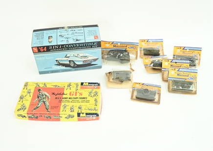
Sold2021GROUPING OF VINTAGE TOY MODELS ETC.Including (8) Roco - Ho Model Miniatures minitanks, (18) Monogram brand U.S. Army military figures, AMT 1964 Corvette Sting Ray customizing kit 1/25 scale. Dimensions: (Sting Ray box) H 3.75" x W 9" xSee Sold Price
Sold2022Western division of Cuba 1885 old antique vintage map plan chartTITLE/CONTENT OF MAP: 'Western division of Cuba' DATE PRINTED: 1885 IMAGE SIZE: Approx 13.0 x 11.5cm, 5 x 4.5 inches (Small) TYPE: Antique wood-engraved map; Scale 1:6,000,000 CONDITION: Good; suitablSee Sold Price
Sold2023U.S ARMY 3RD PERSONNEL COMMAND LOT(1) UNIT INSIGNIA ENAMEL PIN & (4) SHOULDER SLEEVE INSIGNIAS: SET OF RED/SILVER AND SET OF GREEN/BLACK.See Sold Price
Sold2023SAVANNAH antique town city plan. Georgia, US. BAEDEKER 1904 old mapTITLE OF THE MAP: 'Savannah' DATE PRINTED: 1904 IMAGE SIZE: Approx 15.0 x 10.0cm, 5.75 x 4 inches (Small) TYPE: Antique colour map; Scale 1:15.000 CONDITION: Good; suitable for framing. However, pleasSee Sold Price
Sold2018ITALY.Italian Front East;Isonzo Front. First World WarTITLE/CONTENT OF MAP: 'Italian Front; East; Inset map of Isonzo Front ' DATE PRINTED: 1920 IMAGE SIZE: Approx 22.5 x 33.5cm, 9 x 13.25 inches (Large) TYPE: Vintage colour map; Scale 1:800,000 CONDITIOSee Sold Price
2021(3) FRAMED 1922 SURVEY OF EGYPT MAPSAll from the 1922 Survey of Egypt, in matching pine bullnose frame, matted and glazed, including: "Temple of Karnak", linen-backed, scale 1:2,000, OS: 34 1/2" x 27 1/2"; SS: 32 1/2" x 25 1/2", repaireSee Sold Price
Sold2024Copacabana Peninsula, Lake Titicaca. Andean States. Bolivia Peru 1885 old mapTITLE/CONTENT OF MAP: 'Copacabana Peninsula' DATE PRINTED: 1885 IMAGE SIZE: Approx 10.5 x 11.0cm, 4.25 x 4.25 inches (Small) TYPE: Antique wood-engraved map; Scale 1:1,000,000 CONDITION: Good; suitablSee Sold Price
Sold2022Main currents of the American Mediterranean.Caribbean/Gulf of Mexico 1885 mapTITLE/CONTENT OF MAP: 'Main currents of the American Mediterranean' DATE PRINTED: 1885 IMAGE SIZE: Approx 9.0 x 11.0cm, 3.5 x 4.25 inches (Small) TYPE: Antique wood-engraved map; Scale 1:45,000,000 COSee Sold Price
7 days LeftJasper52Africae / Africa by Bertius / Langenes 1603 old antique vintage map plan chartUS$260
7 days LeftJasper52Ireland by John Thomson. Coach roads 1817 old antique vintage map plan chartUS$260
Jun 20The Ross Art GroupOriginal Vintage WWII Poster Give Us More B-25s Air Force by Heaslip 1944US$900
7 days LeftJasper52WEST CORNWALL. Land's End Lizard Penwith Roseland St Agnes St Ives CARY 1832 mapUS$260
3 days LeftThriftiques of IowaVintage Oriental hand carved chick hatching in shell. Artist signedUS$11(2 bids)
2 days LeftPotter & Potter AuctionsFECHNER, Christian (1944 - 2008). The Magic of Robert-Houdi...US$150(1 bid)
6 days LeftThe Benefit Shop Foundation Inc.Vtg Sterling Silver US Army Military Police RingUS$30(4 bids)
JG AutographsAndrew Mellon - Businessman, Industrialist, Secretary of the Treasury - Autographed Personal CardUS$25(1 bid)
6 days LeftThe Benefit Shop Foundation Inc.Vintage Hallmarked Sterling Silver Figural DishUS$30(3 bids)