Sold2022Vintage Map Print - America - Map of Manhattan - New York City - United StatesTitle: Vintage Map Print - America - Map of Manhattan - New York City - United States Date/Period: 1938 Dimension: 33 cm x 26 cm Material: Paper Additional Information: Vintage map of Manhattan. ThisSee Sold Price
Sold20241876 New York City, New York Vintage Old Panoramic NY City Map1876 New York City, New York Vintage Old Panoramic NY City Map -Print on Matte Paper-size: 24x18.See photo for description . We pack and ship for you. Good conditionSee Sold Price
Sold2022Map of Paris 1576Map of Paris French Munster copy of 16th Century Walled City Framed Great Graphics & Really Interesting Map print not engraving Great Vintage Condition Measuring 18" x 17" Out of New York City EstateSee Sold Price
Sold2021Fine map of New York City and Brooklyn, 1872Title: Fine map of New York City and Brooklyn, 1872 Description: Beautifully centered double-page vintage map of Manhattan Island and Brooklyn, with inset of the Northern Portion of New York City andSee Sold Price
Sold2021VINTAGE OLD NEW YORK CITY MAP, 4 in 1, MANHATTAN,VINTAGE OLD NEW YORK CITY MAP, 4 in 1, MANHATTAN, SUBWAY, FINANCIAL SECTION etc. VINTAGE OLD NEW YORK CITY MAP, 4 in 1, MANHATTAN, SUBWAY, FINANCIAL SECTION etc. Description Old Vintage GEOGRAPHIA LATSee Sold Price
Sold2023Atlas of the Borough of Manhattan, City of New York, Vol II 1906America, 20th century. 10+ plate maps from Atlas of the borough of Brooklyn, city of New York. This lot contains maps from Volume II, which archives 23rd St to 72nd Street. Hugo Ullitz; engravingsSee Sold Price
Sold2020Vintage How To Get There Map Of New York CityThis is an excellent map of New York City by the Barkan System Street Directory Company in 1946. The map covers the boroughs of Manhattan and the Bronx in extraordinary detail. In Manhattan, it coversSee Sold Price
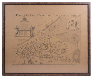
Sold2023REPLICA OF LAING'S MAP OF MANHATTAN"A Plan of the City of New York from an actual Survey" for His Excellency John Montgomerie, by William Bradford, printed on tan paper, in a faux tortoiseshell frame, under glass, 23" x 26", good condiSee Sold Price
Sold2021Scarce SDUK map of New York City, 1840Elusive vintage 1840 Society for the Diffusion of Useful Knowledge (S.D.U.K.) city map or plan of New York City. Shows southern Manhattan from the Battery northwards to 42nd Street and portions of adjSee Sold Price
Sold2021Goerck/Mangin Plan of N. Y. City, Scarce 1856 HaywardManhattan. The 1856 Hayward edition, illustrated in D. T. Valentine’s Manual, is said to be the only vintage version of this map attainable by most collectors. The Common Council of New York comSee Sold Price
2023Antique Map Print - America - Map of New York - Pennsylvania - Jacques BellinTitle/Artist: Antique Map Print - America - Map of New York - Pennsylvania - Jacques Bellin Date: 1757 Material: Paper Dimensions: 37 cm x 25 cm Description: Carte de la Nouvelle Angleterre, NouvelleSee Sold Price
Sold2019Framed New York City Subway Map PrintFramed New York City Subway Map Print. This print of the New York City subway system map is professionally framed in a modern frame. 37.6 inches x 25.5 inches in frame.See Sold Price
Sold2024Map Of New York City, 1839 Silk ScreenA silk screen print of a Map of New York City, 1839, showing surrounding villages, farms and estates. Prepared by Deans Who Were Established in that year. Approx 15,25 x 24.25 inches Moderate discolorSee Sold Price
Sold2017Two hand colored engraved double page large folio mapsTwo hand colored engraved double page large folio maps including The United States of America and Map of New York and the Adjacent Cities. 16 1/2" x 27" and 17 1/2" x 27" Provenance: Property from CSee Sold Price
Sold2023Vintage Maps of New York City - LithographsTwo vintage color lithograph maps of New York City, "Wards and Senate Districts", one framed in plexiglass, the other matted. Provenance: Phyllis Lucas Gallery, NYC. [Art: 7.5" H x 36" W; Frame: 14" HSee Sold Price
Sold2017"AMERICA - A NATION OF ONE PEOPLE FROM MANY COUNTRIES"Lithograph map - "America - A Nation of One People From Many Countries" signed in-the-stone "Emma Bourne." Issued by The Council Against Intolerance in America. 17 East 42nd. Street, New York City 17.See Sold Price
Sold20224 Vintage World Map PrintsPenn Prints New York. Each overall with frame 17-1/4" high x 21-1/4" wide. LR IMPORTANT: Before bidding, please read the terms and conditions. When you registered for the auction you agreed to these tSee Sold Price
Sold2021Vintage Map Of Greenwich Village, New York CityOriginal 1960 map of Greenwich Village, New York City by Lawrence Fahey. Stated 1st edition. Dimensions: 25" X 38" overall including frameSee Sold Price
Sold2024Vintage 1972 Massimo Vignelli New York Subway MapVintage 1972 Massimo Vignelli New York Subway Map -Print on Matte Paper-size: 24x28.See photo for description . We pack and ship for you. Good conditionSee Sold Price
Sold2020VINTAGE 1932 SUPERVUE MAP of NYC NEW YORK CITY, SAMUELVINTAGE 1932 SUPERVUE MAP of NYC NEW YORK CITY, SAMUEL FREEDMEN, SOUVENIR TRAVEL VINTAGE 1932 SUPERVUE MAP of NYC NEW YORK CITY, SAMUEL FREEDMEN, SOUVENIR TRAVEL Old Vintage NEW YORK CITY Tourist's MaSee Sold Price
Sold2021INVADER 'Invasion Map NYC' Lithograph Print'Invasion Map New York City' by Invader, 2003 16.5 x 23.6 Inches Offset lithograph on fine art paper. Open edition (Sold Out). Mint Condition. Ships folded. ARTIST BIO Invader is one of the most enSee Sold Price
Sold2023US WALL MAPS AND AERIAL VIEW OF NEW YORK CITYA lot of three antique and vintage wall maps of New York. The lot includes a 1914 map of New York bay and harbor, a D. Lambert Railing Co. color map of New York State, and an aerial view of Hudson RivSee Sold Price
Sold20231860 New York City Business MAPS Manhattan Illustrated Corporation Plates Foldouts1860 New York City Business MAPS Manhattan Illustrated Corporation Plates Foldouts Manual of the Corporation of New York is a rare, Civil War-era handbook written for businesses and businessmen in NewSee Sold Price
Sold20222 maps, colonial New York & North America, New York2 maps, colonial New York & North America, New York City, North River, Hudson Valley, "for D1, Valentine's Manual, for 1860, 13' by 10" & map of North America, United States, with various illustrationSee Sold Price
Jun 09Estate Collection Auctioneer1986 Photo The Staten Island Anchorage viewed from Narrows Bridge TowerUS$250
6 hrs LeftWhite Knight Auction, IncHenri Cartier Bresson, 1947 New York City Manhattan Fire AftermathUS$100
3 days LeftJasper521874 Holmes Plan of New York's Upper East Side -- Map of the Common Lands from 76th to 93rd StreetUS$750
Jun 02Collective HudsonBalthasar Frederich Lazelt Colored Engraving Print Of Lower Manhattan Harbor Entrance Published 1775US$200
5 days LeftKamy INCDesignart New York City Manhattan Skyscrapers Cityscape Canvas Print - 32" X 40"US$145