Sold2023U.S. MILITARY WWII FIELD MAPS 1943-1944(5)170300 U.S. MILITARY WWII FIELD MAPS 1943-1944(5) U.S. military WWII field maps 1943-1944 to include one original Europe Road Map Series 1 first edition France with name of soldier Caldwell, two WWIISee Sold Price
Sold2022UNIFORM AND RELIC GROUPING OF A LEDO ROAD C.B.I. VETERANWorld War II uniform, map, medals and 'blood chit' grouping of Lt. Robert Finkel, 181st Signal Repair Co., 4011 Signal Battalion, which was crucial in the operation of the important Ledo Road. The LedSee Sold Price
Sold2024Keith Haring Artwork Signed on a Shell Oil New York Road Map 18 in. x 24 in.Keith Haring Artwork Signed on a Shell Oil New York Road Map 18 in. x 24 in. size: 18 x 42 open - rippingSee Sold Price
Sold2022HUSKY GASOLINE SERVICE STATION MAP DISPLAY W/ HUSKY ROAD MAPS.SST. An excellent and complete example of this Circa 1950's Service Station Road Map Display from Husky showing a Tin Husky Sign at the face and complete with Maps. CONDITION: Display is in overall exSee Sold Price
Sold2022New road map of the city of Paris 1839 Rosselin editeur engravingNouveau plan routier de la ville de Paris, Guide exacte de cette capitale : en 12 arrondissemens avec leurs mairies et en 48 quartiers, 1839V. ROSSELIN (19th century), print editor, Paris, EstablishedSee Sold Price
Sold2022British road maps.- Ogilby (John) The Roads fromNO RESERVE British road maps.- Ogilby (John) The Roads from Chelmsford in Essex to St. Edmonds-Bury in Suffolk & Saffron-Walden in Essex, strip road map, engraving with hand-colouring, on thin laid paSee Sold Price
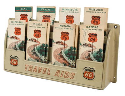
Sold2023Vintage Phillips 66 Road Map Embossed Display RackVintage Phillips 66 embossed plastic road map display rack full with original 1930s Phillips 66 maps. Rack has discoloration, some expected chips/ cracks, and wear from use and age. Displays well withSee Sold Price
Sold2019Road-Map of England And WalesTitle: Road-Map of England And Wales Publication Date: 1835-03-25 Cartographer: BACON, G. W. & CO. Publisher: G.W. BACON & CO. Dimension: 33Height - 26.5Width Retailed by Forster Groom & Co. Ltd. DissSee Sold Price
Sold2021Road Maps by Johnathan Schultz"Road Maps" by Johnathan Schultz is an original 3D sculpture created with 23kt gold leaf on Acrylic, 18kt gold plate. Frame Dimensions 13.5 x 13.5 x 4 inSee Sold Price
Sold2021Shell Tin Litho Road Maps DisplayCanadian. 1940s. Lithographed tin. Includes an assortment of seventeen (17) used road maps. Marked, "St. Thomas Metal Signs Ltd. St. Thomas Ontario" upper rear. 19 1/2 x 13". One added mounting hole tSee Sold Price
Sold2020Approximately 50 Antique Service Station Road MapsCirca 1920s-30s, Includes Nebraska, Michigan, Missouri, Iowa, Standard Oil, Sinclair, Shell, and MoreSee Sold Price
Sold2021Mobilgas road maps brochure displayMetal display with approximately 8- various maps. Includes several from Ohio, New York, Nebraska, Buffalo -Niagara, Minnesota and New England. 12 3/4 in wide 24 in tall.See Sold Price
Sold2020MOBIL GASOLINE SERVICE STATION TIN ROAD MAPS DISPLAY W/SST. A very nice example of this Service Station Road Maps Display from Mobil Gasoline. The paint and body are both in excellent condition, showing minimal age wear and minor surface scratches. The grSee Sold Price
Sold2023Original picture post WWII HITLERS BALCONY / COPYRIGHT ATELIER BADEKOWDescription: Original picture post WWII HITLERS BALCONY / COPYRIGHT ATELIER BADEKOWSee Sold Price
Sold2018India.- Joseph (Charles) Map of the Grand Trunk RoadIndia.- Joseph (Charles) Map of the Grand Trunk Road from the Karamnassa to the Sutledge, Part Second, from Agra to Ferozepoor, large folding road map of one of the oldest and longest trade routes linSee Sold Price
Sold2017Petroliana cans & paper (6), Conoco TransmissionPetroliana cans & paper (6), Conoco Transmission Grease, Marland Oil 5 gal drum, Marland Michigan road map, blotters & plant pass from Ponca City, OK, all VG cond, up to 13"H x 11.5"Dia.See Sold Price
Sold2023Gulf Map and Tourgide Service w/Logo Metal Map Display (TAC)rated 8.5, 14"x18"x3.5", metal map display has very good color and shine, display panel is clean, has wear around the perimeter, comes with 10 Gulf road maps. TAC #046567See Sold Price
Sold2022Collection of (7) Disneyland Brochures.(Disneyland, 1955-61) A collection of (7) Disneyland brochures. These early Park artifacts include a 1955 complimentary "Official Disneyland Road Map," a 1955 informative guide offering main routes anSee Sold Price
Sold2021Ephemera AssortmentEphemera Assortment Including books, magazines, sheet music, newspapers, coloring books, road maps and advertising Property from: Mooncat Antiques, Lake in the Hills, Illinois Condition: Good to Fair,See Sold Price
Sold2023Original picture POST WWII Adolf Hitler’s Balcony / COPYRIGHT ATELIER BADEKOWDescription: Original picture POST WWII Adolf Hitler’s Balcony / COPYRIGHT ATELIER BADEKOWSee Sold Price
Sold2022WWII US Air Force Safety Poster "They Cheer When You Forget Your Maps"WWII Political Propaganda Poster."They Cheer When You Forget Your Maps." WWII Aviation Safety Poster issued by US Air Force. Nice Condition - Just some fold lines. Framed. Measures 24" wide x 19.5" taSee Sold Price
Sold2015Official map of the county of San Mateo, California,Official map of the county of San Mateo, California, showing the new boundary line and delineating the lines of cities, towns, private claims, ranchos, water works and rail roads Official Map of the CSee Sold Price
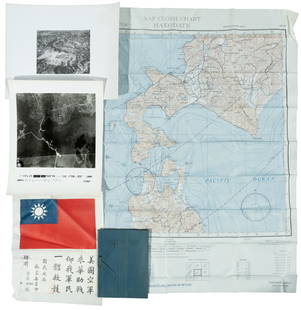
Sold2022WWII fighter pilot maps and kitHeading: (World War II) Author: Title: Fighter pilot materials from World War II Place Published: Publisher: Date Published: c.1943-1945 Description: 1 set. Includes:See Sold Price
2 hrs LeftThe Bidder AuctionsUncommon! Map of transportation routes of Palestine - Survey of Palestine Motor Map, 1935 Road mapUS$30
6 days LeftJasper52Operation Torch Nov 1942-May 1943. World War 2. Western Mediterranean 1966 mapUS$15
Jun 23Schilb Antiquarian Rare Books1890 Livingstone 1ed In Darkest Africa Henry Stanley Emin Pasha Expedition MAPUS$28(6 bids)
Jun 08Early American History Auctions1853 Specialized Map, Railroads in the United States in Operation and Progress... Treasury DeptmentUS$200(1 bid)
2 days LeftLink Auction GalleriesRoad to Rome: Salerno Naples Volturno Cassino Anzio Rome. (A 56-page WWII booklet detailing theUS$25
5 days LeftJasper521893 Civil War Map of Siege of Yorktown, Battle of Siloh and Army of Ohio Operations -- Plan ofUS$55
5 days LeftJasper521893 Civil War Map of Knoxville Area -- Topographical Map of the Approaches and Defences ofUS$70
5 days LeftJasper521893 Civil War Map of Yorktown -- Secession Works at Yorktown [with] The Position of Yorktown withUS$55
5 days LeftJasper521893 Civil War Map Washington, Paducah, KY and Logan's Cross-Roads plus Mill Springs, KY -- DefensesUS$70
Jun 10Donny Malone AuctionsRobert Angeloch 1922-2011, Color Woodcut, Grand Gorge Road, Pencil Signed and Dated 1982US$10
6 days LeftJasper52West Africa WW2 Nigeria Sudan Egypt. Takoradi air reinforcement route 1954 mapUS$15
6 days LeftJasper52World War 2 Europe Battle of the Atlantic 1939-43 Axis Expansion limits 1959 mapUS$15


![1893 Civil War Map of Yorktown -- Secession Works at Yorktown [with] The Position of Yorktown with (1 of 1)](https://p1.liveauctioneers.com/5584/331064/178466378_1_x.jpg?height=282&quality=70&version=1716924723)


