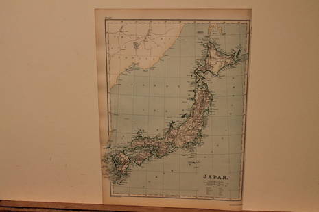
Sold20211886 Map of JapanAuthor: Blackie Title: 1886 Map of Japan Medium: Ink on Paper Dimensions: 10.5"X15" Map of Japan dated 1886. Part of the Imperial Atlas of Modern Geography. This was the revised edition under the supeSee Sold Price
Sold2015Framed MapChina and Japan 1886, by Wm. M. Bradley and Bros., 18" x 24" image, 23" x 29.5" framedSee Sold Price
Sold2022MAP, Japan & Korea, MercatorHondius' Richly Ornamented Map of Japan. Japan & Korea. Mercator/Hondius, Iaponia, from Gerardi Mercatoris - Atlas sive Cosmographicae, 1634 (published). Hand Color. Superb map of Japan based on the OSee Sold Price
Sold2022MAP, Japan & Korea, JanssonJapan & Korea. Jan Jansson, Nova et Accurata Iaponiae, Terrae Esonis, ac Insularum Adjacentium. Ex Novissima Detectione Descriptio, from Atlas Contractus, 1666 (circa). Hand Color. This superb folio mSee Sold Price
Sold20201886 Map of Indian NationsAuthor: Clare Title: 1886 Map of Indian Nations Medium: Ink on Paper Dimensions: 14.5"X11" Description: Map dated 1886 part of Watson's General Atlast. Engraved by I.S. Clare it captures the Indian NaSee Sold Price
Sold2023MAP, Japan, YamashitaOmi Province, Japan. Shigemasa Yamashita, [Omi Province] ?mi no Kuni saikenzu, 1824 (circa). Black & White. This wall-sized woodblock map of the Omi Province was created by Shigemasa Yamashita. This hSee Sold Price
Sold2021Tallis, John (Pub) 1852 Map. Japan & Corea. KoreaSteel Engraved Map with Original Outline Hand Color Published 1852-56 by John Tallis, London for "The Universal Pronouncing Dictionary" by Thomas Wright. Drawn & Engraved by John Rapkin. Centre fold aSee Sold Price
Sold20211886 Map of the Chinese EmpireAuthor: Blackie Title: 1886 Map of the Chinese Empire Materials: Ink on Paper Size/Dimensions: 21"X15" Description: Map of the Chinese Empire dated 1886. Part of the Imperial Atlas of Modern GeographySee Sold Price
Sold20211886 Map of the Philippine IslandsAuthor: Blackie Title: 1886 Map of the Philippine Islands Medium: Ink on Paper Dimensions: 10.5"X15" Map of the Philippine Islands dated 1886. Part of the Imperial Atlas of Modern Geography. This wasSee Sold Price
Sold20201886 Map of LondonAuthor: Cram Title: 1886 Map of London Medium: Ink on Paper Dimensions: 21.5"X14.5" Map of London dated 1886. Engraved and published by George Cram in Chicago. Part of his World Atlas. Double folio maSee Sold Price
Sold20211886 Map of AfricaTitle: 1886 Map of Africa Author: Blackie Medium: Ink on Paper Dimensions: 21"X15" Description: Map of Africa dated 1886. Part of the Imperial Atlas of Modern Geography. This was the revised edition uSee Sold Price
20211886 Map of AfricaAuthor: Blackie Title: 1886 Map of Africa Materials: Ink on Paper Size/Dimensions: 21"X15" Description: Map of Africa dated 1886. Part of the Imperial Atlas of Modern Geography. This was the revised eSee Sold Price
Sold20211886 Map of MontanaAuthor: Cram Title: 1886 Map of Montana Medium: Ink on Paper Dimensions: 21"X13.5" Map of Montana dated 1886. Printed and published by George Cram in Chicago. Part of his World Atlas. Key lower left.See Sold Price
Sold20201886 Map of ItalyAuthor: Watson Title: 1886 Map of Italy Medium: Ink on Paper/Glass/Wood Dimensions: 17"X20" Map of Italy from Watson's Illustrated Atlas of the World dated 1886. Published by Iliff&co. in Chicago. MapSee Sold Price
Sold20191886 map of New OrleansVery clean and sharp map of New Orleans. Lovely original hand coloring. Published in Mitchell’s 1887 New General Atlas. Nicely centered. A beautiful example with no real faults. 9.375 x 11.125. ReseSee Sold Price
Sold20221886 map of Florida showing all RR lines1886 Railroad map of Florida showing the entire state in one view by Phillips & Hunt. From an 1886 edition of People’s Encyclopedia of Universal Knowledge. Shows proposed rail routes from LeesbSee Sold Price
Sold2023SW ASIA. Persia (Iran) Afghanistan Baluchistan. Persian Gulf. Caspian 1886 mapPersia, Afghanistan and Beloochistan'. Engraved by Edwd. Weller, Red Lion Square; drawn by Edwd. Weller F.R.G.S (1886). Antique colour map, 35.5 x 51.0cm, 14 x 20 inches; Please note that this is a foSee Sold Price
Sold20201886 Map of CharlestonAuthor: Cram Title: 1886 Map of Charleston Medium: Ink on Paper Dimensions: 11"X14.5" Map of Charleston dated 1886. Engraved and printed by George Cram in Chicago. Out of all the city maps, CharlestonSee Sold Price
Sold2021WWII UNITED PRESS WAR MAP w 7 INDIVIDUAL MAPS JAPANTitle: WWII UNITED PRESS WAR MAP w 7 INDIVIDUAL MAPS JAPAN HAWAII WORLD PACIFIC THEATER Additional Information: WWII UNITED PRESS WAR MAP w 7 INDIVIDUAL MAPS JAPAN HAWAII WORLD PACIFIC THEATER WWII UNSee Sold Price
Sold20211886 Map of Arabia and the Persian GulfAuthor: Blackie Title: 1886 Map of Arabia and the Persian Gulf Medium: Ink on Paper Dimensions: 21"X15" Map of Arabia and the Persian Gulf dated 1886. Part of the Imperial Atlas of Modern Geography. TSee Sold Price
Sold20211886 Map of AsiaAuthor: Blackie Title: 1886 Map of Asia Materials: Ink on Paper Size/Dimensions: 21"X15" Description: Map of Asia dated 1886. Part of the Imperial Atlas of Modern Geography. This was the revised editiSee Sold Price
Sold20201886 Map of CubaAuthor: Cram Title: 1886 Map of Cuba Medium: Ink on Paper Dimensions: 22"X14.5" Map of Cuba dated 1886. Engraved and published by George Cram in Chicago. Map key located middle left. Upper right inserSee Sold Price
Sold20201886 Map of Porto RicoTitle: 1886 Map of Porto Rico Author: Cram Medium: Ink on Paper Dimensions: 22.5"X14.5" Description: Map of Porto Rico dated 1886. Engraved and published by George Cram in Chicago. Double folio map wiSee Sold Price
5 days LeftJasper52SCANDINAVIA. Sweden Norway.Railways.Scale in Swedish & Norwegian miles 1886 map$30
23 hrs LeftTrillium Antique Prints & Rare BooksPrevost - Map of Japan with part of Korea and China$50
23 hrs LeftCrescent City Auction GalleryWilliam H. Williams (1817-1886), New Orleans "Map of the Sixth District and Carrollton," 1871, H.-$650
May 18Trillium Antique Prints & Rare BooksPrevost - Map of China, Korea, Japan, Phlippines and Surrounding Islands$50
Featured4 days LeftJasper52Mitchell’s Map of Asia showing travel routes London, India, China & Japan, 1860$45
5 days LeftJapan Ancient Art Co. LTDLi Keran's Ten Screen Paper Vertical Axis of the Red Map of Wanshan$500
May 21BonhamsMaharajah Jagatjit Singh of Kapurthala, My Travels in China, Japan and Java, 1903 Hutchinson & C...£1,200


![MAP, Japan, Yamashita: Omi Province, Japan. Shigemasa Yamashita, [Omi Province] ?mi no Kuni saikenzu, 1824 (circa). Black & White. This wall-sized woodblock map of the Omi Province was created by Shigemasa Yamashita. This h](https://p1.liveauctioneers.com/6576/279721/147265524_1_x.jpg?height=310&quality=70&version=1677104593)


