Sold2021Earliest Obtainable map of 1st Survey of ManhattanTitle: Earliest Obtainable map of 1st Survey of Manhattan Description: "Scarce and most important section of the three-panel lithographed folding map by D. T. Valentine in 1862, replicating the 1664 NSee Sold Price
Sold20191853 Santa Barbara, Calif., U. S. Coast SurveyReserve Reduced! One of the earliest obtainable maps of Santa Barbara. Map is centered on the town of Santa Barbara and shows roads, rivers, mountains, etc. The Mission and Ruined Village are shown inSee Sold Price
Sold2017German Moscovia Map PrintTitled "Mosvavw", hand colored, note on verso "Braun and Hogenburg, Cologne c. 1585 The earliest obtainable map or view of Moscow". Map, 15-1/2" x 21", framed 22-1/2" x 28"See Sold Price
Sold20181552 Transsylvania XXI Nova TabulaBy: Sebastian Munster Date: 1552 (Published) Basel Dimensions: 12 x 14.75 inches (30.1 cm x 37.5 cm) This marvelous and scarce Munster woodcut is the earliest obtainable map to specifically depict TraSee Sold Price
Sold20201574 Bruxella.The earliest obtainable map of Brussels, Belgium. The plan shows an idealized almost circular view of the city with city walls nearly entirely ringed by a moat on one side and the River Senne on the oSee Sold Price
Sold2017S. Augustus Mitchell: Map of Iowa, 1848Map: Iowa Maker: S. Augustus Mitchell Date: 1848 Size: 13.5 x 16.5 inches One of the earliest obtainable maps of Iowa Condition: Map date half scraped off. Image close to edge as published. Tiny repaiSee Sold Price
Sold2020Galápagos IslandsTitle: Galápagos Islands Description: By Emanuel Bowen. From. John Harris’s A complete collection of voyages and travels. Published. London. One of the earliest obtainable maps of just the GalápagSee Sold Price
Sold2018Morden: Antique Map of Florida & the Great Lakes, 16931693 map of Florida and the Great Lakes by Robert Morden. 5 x 5 inches. A very special map--one of the very earliest obtainable English maps of the American colonies. A Map of Florida and Ye Great LakSee Sold Price
Sold2022Scarce 1833 Finley map of Alabama – near fineExcellent example of Anthony Finley's very scarce 1833 map of Alabama from a rare late edition of his New General Atlas, one of the earliest obtainable separate maps of Alabama. Map is hand-colored bySee Sold Price
Sold2024Second State of Morden's Map of Virginia c.1687Second State of Morden's Map of Virginia. Fine example of Robert Morden's map of Virginia, one of the earliest obtainable English maps of the Chesapeake the region. Beginning in the 1670s, theSee Sold Price
Sold2018Antique Survey Map of Earliest American Railroad PlanTitle/Content of Map: 1829 Survey Map of the Earliest American Railroad Plan -- Plan of a Survey for the Proposed Boston and Providence Rail-Way Date Printed: 1828 Boston Cartographer: J Hayward Size:See Sold Price
Sold2022[WEST FLORIDA] CHESTER, PETER. Three crudely printed land grants for West Florida, each engrossed in[WEST FLORIDA] CHESTER, PETER. Three crudely printed land grants for West Florida, each engrossed in manuscript, with an attached manuscript survey map. Pensacola, Florida, 1st September, 1777; 24 NovSee Sold Price
Sold2017Antique French Map and Plan of Boston, MassachusettsTitle/Content of Map: Antique French Map and Plan of Boston, Massachusetts Date Printed: 1757 Cartographer: Bellin, Jacques Nicolas Size (in): 10 x 6 One of the earliest obtainable town plans of BostoSee Sold Price
Sold2017The History of Topographical Maps, 1st EdTitle: The History of Topographical Maps. Symbols, Pictures and Surveys. London. Thames and Hudson. 1980 Author(s): Harvey, P.D.A First edition Condition: Fine copy in fine dust jacket (in mylar). 199See Sold Price
Sold20237 Early Tennessee Geological Reports, incl. 3 TN Maps & author Troost inscribedSeven (7) Tennessee geological survey reports including 4 by Gerard Troost (Netherlands/Tennessee, 1776-1850), first State Geologist, with three rare 1840 Tennessee maps. 1st item: FIFTH GEOLOGICAL RESee Sold Price
Sold2024Goerck's 1785 working survey of the Common Lands that became Fifth Avenue[MAP-NEW YORK] [GOERCK, CASIMIR, attributed to]. A manuscript survey of the Manhattan Common Lands, dated 1785. A manuscript survey plan in ink on joined sheets, with irregular edges but the image subSee Sold Price
Sold2020Rare 1st ed/1st state NYC map by ColtonA rare and beautiful example of J. H. Colton map of New York City and vicinity, including Manhattan as well as parts of Brooklyn, Jersey City, Hoboken, and Queens. This is the first edition, first staSee Sold Price
Sold2022ALLEN, Thomas:ALLEN, Thomas: ALLEN, Thomas: The History of the County of Lincoln. From the earliest period to the present time, 2 vols. Bound in 1. Leeds, J Saunder, 1830 (but 1834), 1st. edn. With 2 maps (one handSee Sold Price
20191874 1st ed CONFEDERATE Narrative of General Johnston1874 1st ed CONFEDERATE Narrative of General Johnston CIVIL WAR Maps Portraits "One of the earliest Confederate reminiscences; strongly partisan, anti-Davis, and defensive in tone." ― Nevins A rSee Sold Price
Sold20191874 1st ed CONFEDERATE Narrative of General Johnston1874 1st ed CONFEDERATE Narrative of General Johnston CIVIL WAR Maps Portraits "One of the earliest Confederate reminiscences; strongly partisan, anti-Davis, and defensive in tone." ― Nevins A rSee Sold Price
Sold2020New Tracks In North America 1stNew Tracks In North America A Journal of Travel and Adventure Engraved in the Survey for a Southern Railroad to the Pacific Ocean During 1867 - 1868. Two volume set. NumerSee Sold Price
Sold2018Large/scarce 1861 map of New York BayReserve Reduced! Large and scarce 1861 coastal map of New York City and its harbor. One of the earliest 19th century charts to depict New York City as we know it today. It shows Manhattan, Brooklyn anSee Sold Price
Sold2020Rand McNally State & County Survey Atlas 1910Title/Content of Map: Rand McNally & Co.'s New Ideal State and County Survey Date Printed: 1910 Material/Medium: Bound Atlas Size: folio, approx. 12x14 inches 1st. edition. Illustrated with colored maSee Sold Price
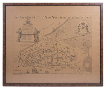
Sold2023REPLICA OF LAING'S MAP OF MANHATTAN"A Plan of the City of New York from an actual Survey" for His Excellency John Montgomerie, by William Bradford, printed on tan paper, in a faux tortoiseshell frame, under glass, 23" x 26", good condiSee Sold Price
Jun 23Schilb Antiquarian Rare Books1877 Geology Geography Surveys 1ed Nevada Wyoming Utah George Wheeler US West 2v$1
May 30Forum AuctionsIndia.- Phillimore (Colonel R. H.) Historical Records of the Survey of India, 4 vol. only (of 5),£1,000
4 days LeftTrillium Antique Prints & Rare BooksWilkes - 4 View Engravings of Sydney, Australia / Mount Shasta, California / Fiji / Rewa, India$100
4 days LeftTrillium Antique Prints & Rare BooksWilkes - 4 Engravings of Trees & Mountains in Nu?uanu Pali, Hawaii / Upolu, Samoa / New South Wales,$100
May 30Forum AuctionsTolkien (J.R.R.) The Hobbit; or There and Back Again, first American edition, first state, Boston£800(1 bid)
Jun 06Freeman's | HindmanDICKENS, Charles (1812-1870). Great Expectations. London: Chapman & Hall, 1861.$3,000
1 day LeftThomaston Place Auction GalleriesEARLY 17TH C. ELIZABETHAN ENGRAVED MAP OF CORNWALL BY WILLIAM KIP AFTER WILLIAM SAXTON$150


![[WEST FLORIDA] CHESTER, PETER. Three crudely printed land grants for West Florida, each engrossed in: [WEST FLORIDA] CHESTER, PETER. Three crudely printed land grants for West Florida, each engrossed in manuscript, with an attached manuscript survey map. Pensacola, Florida, 1st September, 1777; 24 Nov](https://p1.liveauctioneers.com/292/250642/130213766_1_x.jpg?height=310&quality=70&version=1654271664)


![Goerck's 1785 working survey of the Common Lands that became Fifth Avenue: [MAP-NEW YORK] [GOERCK, CASIMIR, attributed to]. A manuscript survey of the Manhattan Common Lands, dated 1785. A manuscript survey plan in ink on joined sheets, with irregular edges but the image sub](https://p1.liveauctioneers.com/292/326828/175962863_1_x.jpg?height=310&quality=70&version=1713473479)


![[MAP]. ORTELIUS, Abraham. Turcici Imperii Descriptio.1592. (1 of 2)](https://p1.liveauctioneers.com/197/329395/177650538_1_x.jpg?height=282&quality=70&version=1715364962)