Sold2021Rand McNally Indexed Atlas of the WorldIncludes 'Foreign Countries' and 'United States', New York and Chicago, 1897, in original green cloth with gilt lettering, together with Rand McNally's Census Atlas of the World, 1912 Foreign CountrieSee Sold Price
Sold2023Rand-McNally Indexed Atlas. New MexicoDescriptionTitle: Rand-McNally Indexed Atlas. New MexicoPublication Date: 1906Cartographer: RAND-MCNALLY & CO.Publisher: RAND-MCNALLY & CO.Height: 19Width: 12.5Page 264 from the Rand-McNally Indexed aSee Sold Price
Sold2024Rand-McNally Indexed Atlas. Dominion of Canada And NewfoundlandTitle: Rand-McNally Indexed Atlas. Dominion of Canada And Newfoundland Publication Date: c1904 Cartographer: RAND, MCNALLY & CO. Publisher: RAND, MCNALLY & CO. Height: 19 Width: 26 From: Rand, McNallySee Sold Price
Sold2017Rand McNally: Indexed Atlas of the World Map of EuropeMap: Rand, McNally & Co.'S Indexed Atlas of the World Map of Europe. Publication Date: 1892 Authors: RAND, MCNALLY & CO., RAND, MCNALLY & CO. Publisher: RAND, MCNALLY & CO. Size: Folio – 19.00 H x 2See Sold Price
Sold2018Antique Rand-McNally Indexed Atlas of the WorldAntique Rand-McNally Indexed Atlas of the World, ca.1898, pages 5-223 present with color maps, binding is broken and front cover is detached and reinforced with brown tape, some pages are torn, 22" xSee Sold Price
Sold2018Rand-McNally Indexed Atlas. Philippine IslandsTitle/Content of Map: Rand-McNally Indexed Atlas. Philippine Islands Date: 1904 ca. Cartographer: RAND, MCNALLY & CO. Size: 26 X 19 Page xxii, xxiii from Rand, McNally & Co.'s Enlarged business atlasSee Sold Price
Sold2019Large Colored Map of Louisiana, 1907, from the RandLarge Colored Map of Louisiana, 1907, from the Rand McNally Indexed Atlas of the World, double folio, showing railroads, presented in a mahogany frame with a gilt liner, H.- 19 1/4 in., W.- 25 3/4 in.See Sold Price
Sold20221882 RR map of Idaho by Rand McNallyFrom a very early Rand McNally Indexed atlas comes this striking and colorful double-page map of Idaho. Extremely detailed topographical features provide a wealth of information on this map. “GOSee Sold Price
Sold2023Scarce early McNally map of Georgia - 1881Early and scarce 1881 Rand McNally Indexed Atlas of the World map of Georgia. Highly detailed, showing counties, towns, rivers, mountains, lakes, roads, railroads, stations, swamps, topography, etc. PSee Sold Price
Sold20171911 Rand McNally Map of IdahoTitle: 1911 Rand McNally Map of Idaho -- Rand McNally Indexed Atlas (Idaho) Cartographer: Rand McNally Origin/Date: 1911, Chicago Size: 19 inches X 25.7 inches A nice county map of Idaho. Detailed witSee Sold Price
Sold2017Rand McNally: Map of British Columbia, 1911Map: 1911 Rand McNally Map of British Columbia -- Rand McNally Indexed Atlas (British Columbia) Cartographer: Rand McNally Year / Place: 1911, Chicago Map Dimensions: 19 X 25.8 in. Condition: ExcellenSee Sold Price
Sold2020Rand McNally Index Atlas of the World Vol 1 1902Rand McNally Indexed Atlas of the World Historical - Descriptive - Statistical Volume I - United States, Rand McNally & Co, Chicago, 1902. Color engraved atlas of the United States.See Sold Price
Sold2020RAND, MCNALLY & CO.'s INDEXED ATLAS of the WORLDPublication Date: 1884 Title: RAND, MCNALLY & CO.'s INDEXED ATLAS of the WORLD Primary Authors: RAND, MCNALLY & CO Publisher: RAND, MCNALLY & CO containing large scale maps of every country and civilSee Sold Price
Sold20231888-9 RAND McNALLY & CO. INDEXED ATLAS OF THE WORLD maps ANTIQUE FOLIORand, McNally & Co.’s new indexed ATLAS OF THE WORLD Chicago; 1888-89 Massive folio. Size 11 by 14.5" Binding is worn with some damages, covers are detached, spine destroyed. Good interior, someSee Sold Price
Sold2023Rand McNally & Co. Indexed Atlas of the WorldIllinois,1881 "Rand, McNally & Co.'s Indexed Atlas of the World Historical and Descriptive" by Rand, McNally & Co. in 1881. Print on paper,15 1/2" x 12". From the collection of a Seekonk, MassachusettSee Sold Price
Sold2018Rand, McNally & Co.'s Indexed Atlas of the World Map ofTitle/Content of Map: Rand, McNally & Co.'s Indexed Atlas of the World Map of New York City Date: 1892 Cartographer: RAND, MCNALLY & CO. Size: 26X19 Pages 62-63 in Rand, McNally & Co.'s Indexed atlasSee Sold Price
Sold2019West Indies Rand, McNally & Co.'S Indexed Atlas Map ofTitle/Content of Map: West Indies Rand, McNally & Co.'S Indexed Atlas Map of the World Map of the West Indies. Date: 1898 Cartographer: RAND, MCNALLY & CO. Publisher: RAND, MCNALLY & CO. Size: 12.3HeiSee Sold Price
Sold2019Rand, McNally & Co.'S Indexed Atlas of the World.Reserve Reduced! Title: Rand, McNally & Co.'S Indexed Atlas of the World. Washington Publication Date: 1888 Cartographer: RAND, MCNALLY & CO. Publisher: RAND, MCNALLY & CO. Size (inches): H19 - W26 MaSee Sold Price
Sold2019Rand, McNally & Co.'S Indexed Atlas of the World.Reserve Reduced! Title: Rand, McNally & Co.'S Indexed Atlas of the World. Oregon Publication Date: 1888 Cartographer: RAND, MCNALLY & CO. Publisher: RAND, MCNALLY & CO. Size (inches): H19 - W26 Map shSee Sold Price
Sold2018Rand, McNally & Co.'S Indexed Atlas of the World Map ofReserve Reduced! Title/Content of Map: Rand, McNally & Co.'S Indexed Atlas of the World Map of Japan.Date: 1892 Cartographer: RAND, MCNALLY & CO. Material/Medium: RAND, MCNALLY & CO. Size: 19 x 25.8 iSee Sold Price
Sold2018Rand, McNally & Co.'S Indexed Atlas of the World Map ofTitle/Content of Map: Rand, McNally & Co.'S Indexed Atlas of the World Map of Philadelphia. Date: 1892 Cartographer: RAND, MCNALLY & CO. Size: 19X25.75 Pages 62-63 in Rand, McNally & Co.'s Indexed atlSee Sold Price
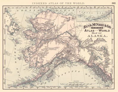
Sold2024Rand, McNally & Co.'S Indexed Atlas of the World Map of AlaskaTitle:Rand, McNally & Co.'S Indexed Atlas of the World Map of Alaska Publication Date: 1892 Cartographer:RAND, MCNALLY & CO. Publisher: RAND, MCNALLY & CO. Height: 9.3 Width: 11.8 Map showing AK withSee Sold Price
Sold2019Large & Scarce Bus. Map of Texas, 1892Impressive and highly detailed full color lithographed map from what is considered the best large format American atlas of the latter nineteenth century. Rand McNally’s 1892 Indexed Atlas of the WorSee Sold Price
Sold2021Rand, McNally & Co.'S New Business Atlas Map ofPublication Date: c1892 Title: Rand, McNally & Co.'S New Business Atlas Map of Chicago. Rand. Mcnally & Co.'S Indexed Atlas of the World Railway Terminal Map Of Chicago. Cartographer: RAND, MCNALLY &See Sold Price
2 days LeftJasper52Austria-Hungary Rand, McNally & Co.'S Indexed Atlas of the World Map of Austria-Hungary.$70
2 days LeftJasper52Rand, McNally & Co.'S Indexed Atlas of the World Map of Germany (Western Sheet). | (Eastern Sheet).$60
2 days LeftJasper521894 Rand McNally Map of British Columbia -- Indexed Atlas of the World Map of British Columbia$35
2 days LeftJasper52Rand, McNally & Co.'S Indexed County & Railroad Pocket Map And Shippers' Guide of Kentucky$80
Oct 12JM Hobby Supply and Railroad Artifact Auctions1879 Rand McNally Township County and Railroad Map of Illinois$40


![Rand-Mcnally Indexed Atlas. [Georgia.] (1 of 1)](https://p1.liveauctioneers.com/5584/343693/186665708_1_x.jpg?height=282&quality=70&version=1726603887)


