Sold201917th century Morden map engravingsTwo 17th century County map engravings by Robert Morden, Hampshire & Monmouth, 37 x 42 cm and 35 x 42 cm respectively, mounted, framed and glazedSee Sold Price
Sold2016DAVID FAIRBANKS (1914-2002)DAVID FAIRBANKS (1914-2002), LITHOGRAPH, A PICTORIAL MAP OF WOODSTOCK IN ULSTER COUNTY, NY: A CARTOGRAPHICAL WHERE'S WHO", C.1930s, UNSIGNED. 19 3/4" X 26 1/4"; FRAMED AND GLAZED 21 1/2" X 28"See Sold Price
Sold2022Large Framed 1846 Map of FloridaLarge Framed 1846 Map of Florida; a reprint of the original, matted, glazed, and mounted in a wood frame. This map shows the state when central Florida was one large county aptly named Mosquito. All aSee Sold Price
Sold2023James Cook Antiquated MapAntiquated framed and glazed map / 'agenera chart' depicting the voyages and discoveries of Captain James Cook height 28 in. x width 42 in. x depth 1.5 in. We happily provide seamless shippiSee Sold Price
Sold2021Antique Framed Map of Columbia County, NY 1829Antique Framed Map of Columbia County, NY, dated 1829. Engraved by Rawdon Clark & Co, Albany, NY. Also marked Rawdon Wright, New York. Map includes locations of mills, churches and stage roads. NicelySee Sold Price
Sold2017Framed map of Chester County, Pennsylvania, copyright 1Framed map of Chester County, Pennsylvania, copyright 1938, compiled and drawn by Charles B MuthSee Sold Price
Sold20231876 Atlas of Illinois- Cook County Map Framed PagTravel back in time to the late 19th century with this enchanting Framed Map Page from the 1876 Atlas of Illinois by Warner & Beers. This exquisite piece showcases the detailed cartography of Cook, DuSee Sold Price
Sold2018FRAMED MAP OF CHESTER COUNTY 1847Framed Map Of Chester County 1847: Dated 1847. This map is adhered to a backing board. Projection and drawing by J.S Bowen, engraved by Edward Yeager of Philadelphia. 50"See Sold Price
Sold2023Framed Map of Spanish & Mexican Land Grants for King RanchFramed and glazed colored map depicting the coastal area between the Rio Grande and The Nueces, showing early Spanish and Mexican land grants for King Ranch as of 1852 We happily provide seamless shiSee Sold Price
Sold2022Map of Albany CountyFramed map of Albany County. Dated 1947. Overall 22" x 30 1/2".See Sold Price
Sold20232 Travel Maps of US: Atwood Pocket Map 1851 & Williams Framed, 18541st item: PHELPS'S NATIONAL MAP OF THE UNITED STATES, TRAVELLERS GUIDE. EMBRACING THE PRINCIPAL RAIL ROADS, CANALS, STEAM BOAT & STAGE ROUTES THROUGHOUT THE UNION, by J. M. Atwood, published by ThayerSee Sold Price
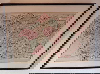
Sold2024FRAMED WARREN COUNTY MAPWARREN CO., NEW JERSEY. MATTED AND FRAMED UNDER GLASS. 29 1/4" X 21 3/4". PLEASE READ CAREFULLY - Terms for Purchasing and Shipping of Auction Items. Please read carefully before bidding. All paymentsSee Sold Price
Sold2017Three framed local maps including Dutchess County NY,Three framed local maps including Dutchess County NY, Putnam County NY, and a hand colored City of Poughkeepsie. All in good condition, late 19th to early 20th century.See Sold Price
Sold20223 FRAMED CHARLESTON COUNTY MAPSThree (3) Framed Charleston County Maps showing Neighborhoods. Includes 1- The Peninsula of Charleston.2- East Cooper; Mt. Pleasant, Isle of Palms, Sullivans Island. 3- Sea Islands; Kiawah, Seabrook,See Sold Price
Sold2020FRAMED 19th c. MAP-DUTCHESS COUNTY, 20" X 13"FRAMED 19th c. MAP-DUTCHESS COUNTY, 20" X 13"See Sold Price
Sold2022Framed 1873 Columbia County MapFramed page from Columbia County Atlas, 1873, showing Malden Bridge, East Chatham, Chatham, Chatham Center, New Concord, and Claverack, 13 3/4" x 16 1/2" framed.See Sold Price
Sold2021FRAMED 1891 MAP OF ULSTER + DUTCHESS COUNTIES, 20" XFRAMED 1891 MAP OF ULSTER + DUTCHESS COUNTIES, 20" X 30.25"See Sold Price
Sold2018AFTER JAMES POLLARD (ENGLISH 1792-1867), LOT (2)AFTER JAMES POLLARD (ENGLISH 1792-1867), LOT (2) LITHOGRAPHS INCLUDING THE NEW LONDON ROYAL MAIL, 1851, FRAMED AND GLAZED-24 X 30" AND THE BEDFORD TIMES, FRAMED AND GLAZED-22 X 25"See Sold Price
Sold2019c1777 Map of the Gulf of Mexico by Thomas Kitchinc1777 Map of the Gulf of Mexico by Thomas Kitchin A very attractive hand coloured map of the Gulf of Mexico by Thomas Kitchin, which has been mounted, framed and glazed. The full title is ‘MAP OF THSee Sold Price
Sold2023Antique Map County of Cumberland EnglandAntique Framed and Hand Colored Map of the County of Cumberland, England by Richard Blome (London Engraver 1600-1705) . 16 inches x 13 inchesSee Sold Price
Sold2023Antique Map County of Northumberland EnglandAntique Framed and Hand Colored Map of the County of Northumberland, England by Richard Blome (London Engraver 1600-1705) . 16 inches x 13 inchesSee Sold Price
Sold2021Antique Framed Map Livingston,Germantown,Claremont NYAntique Framed Map of Livingston, Germantown and Claremont, Columbia County, NY. Dated 1850. Engraved by R.H.Pease, Albany, NY. Lovely early map is nicely framed in dark brown wood, and wired on the bSee Sold Price
Sold2022Vintage 1950 Chas. E. Shannahan Talbot Co. Maryland Mapmeasuring 25" x 28" high framed 1950 Talbot County, Maryland Map mounted on linen with pencil notes written on right hand side. "Seats of Talbot County" #41 of 100 copies made.See Sold Price


![Antiphonary]. Manuscript leaf, (1 of 2)](https://p1.liveauctioneers.com/1782/326783/175979820_1_x.jpg?height=282&quality=70&version=1714059003)


