Sold2022(MISCELLANEOUS MAPS.) Group of 18 double-page or folding engraved European regional maps.(MISCELLANEOUS MAPS.) Group of 18 double-page or folding engraved European regional maps. Folio sheets; European makers. 17th-18th centuries - Eugene Henry Fricx. Les Costes du Boulenois, et le pas deSee Sold Price
Sold2022(MISCELLANEOUS MAPS.) Group of 19 double-page engraved maps.(MISCELLANEOUS MAPS.) Group of 19 double-page engraved maps. European makers, 17th-18th centuries. Vp, vd - Mercator/Hondius. Candia cum Insulis Aliquot circa Graeciam. (Crete and other Greek islands)See Sold Price
Sold2022CHATELAIN, HENRI. Group of 9 double-page or folding engraved maps, mapsheets, and historical tablesCHATELAIN, HENRI. Group of 9 double-page or folding engraved maps, mapsheets, and historical tables from Atlas Historique. Folio sheets; condition generally fine. Amsterdam, circa 1720See Sold Price
Sold2022BELLIN, JACQUES NICOLAS; after. Group of 19 engraved maps from the Dutch edition of Bellin'sBELLIN, JACQUES NICOLAS; after. Group of 19 engraved maps from the Dutch edition of Bellin's Histoire General des Voyages. Full-page, double-page, and folding engraved maps; original hand-coloring; faSee Sold Price
Sold2019MARSHALL, John (1755-1835). The Life of GeorgeMARSHALL, John (1755-1835). The Life of George Washington: Maps and Subscribers' Names. Philadelphia: C.P. Wayne, 1807. Atlas volume only, 4to (279 x 222 mm). 10 engraved folding maps (8 double-page),See Sold Price
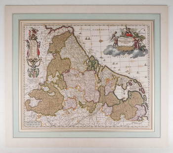
Sold2020Visscher, Claes .Germaniæ Inferioris XVIIVisscher, Claes .Germanie Inferioris XVII Provinciarum. Fine hand colored engraved double-page map. 18-1/2 x 22-1/2 inches plus margins, blank on verso, neatly matted; some browning, generally sound.See Sold Price
Sold2022ORTELIUS, ABRAHAM. Group of 6 double-page engraved maps.ORTELIUS, ABRAHAM. Group of 6 double-page engraved maps. Antwerp, 1603 - Cambriae Typus. (Wales). 16¾x21 inches sheet size, wide margins, Latin text on verso; original hand-color in full; large cSee Sold Price
Sold2015GRAECIA. Engraved Map. [C. late1600s-mid-1700s.][Greece] GRAECIA. Above right-center of lower border: “Per Gerardum Mercatorem Cum Priuilegio.” [C. early 1600s.] Double-page engraved map. 14 x 18 ¼ in. French text on verso, page numbers “605See Sold Price
Sold2021Atlases.- Guthrie (William) An Atlas to Guthrie'sAtlases.- Guthrie (William) An Atlas to Guthrie's Geographical Grammar, title, engraving of an Armillary Sphere, and 27 folding or double-page engraved maps hand-coloured in outline, contemporary inkSee Sold Price
Sold2022SEUTTER FAMILY; engraved by TOBIAS CONRAD LOTTER. Group of 25 small-scale double-page engraved maps.SEUTTER FAMILY; engraved by TOBIAS CONRAD LOTTER. Group of 25 small-scale double-page engraved maps. 8¼x12½ inches each sheet size, wide margins; original hand-color in outline; mostly verySee Sold Price
Sold2022SENEX, JOHN. Group of 25 full-sheet and double-page engraved maps in fine original hand-color.SENEX, JOHN. Group of 25 full-sheet and double-page engraved maps in fine original hand-color. 12 large two-sheet double-page maps measuring approximately 40x26 inches each; 13 unfolded full-sheet mapSee Sold Price
Sold2023WILLEM BLAEU (1571-1638) MAP of NORMANDIADouble-page engraved map with hand-colored highlights and printed on heavy laid paper 18 3/4 x 23 inches. framed 21 1/2 x 27 inches (overall)See Sold Price
Sold2021(HOLY LAND.) Johannes Janssonius; and Georg Horn.(HOLY LAND.) Johannes Janssonius; and Georg Horn. [Regions of the 12 Tribes of Israel]. Together six double-page or folding engraved mapsheets to form a large wall map. Folio sheets, a few margins triSee Sold Price
Sold2016America.- Burr (David H.) - An Atlas of the State ofContaining a Map of the State and of the Several Counties, [third edition], engraved title, 51 hand-coloured engraved maps and plans on 52 sheets as issued, including double-page and folding, some foxSee Sold Price
Sold2022(COLONIAL NORTH AMERICA.) Richard William Seale. A Map of North America with the European(COLONIAL NORTH AMERICA.) Richard William Seale. A Map of North America with the European Settlements & Whatever Else is Remarkable in ye West Indies. Double-page engraved map of North America featuriSee Sold Price
Sold2018WORCESTERSHIRE: by ROBERT MORDEN from Camden'sDATE PRINTED: 1772 IMAGE SIZE: Approx 40.0 x 45.5cm, 15.75 x 17.75 inches (Large); Please note that this is a folding map. TYPE: Double page folio copperplate engraved map CONDITION: Good; suitable foSee Sold Price
Sold2023(CARIBBEAN.) Group of 4 seventeenth century engraved maps.(CARIBBEAN.) Group of 4 seventeenth century engraved maps. Vp, vd - Mercator/Hondius. Cuba Insula, Hispaniola Insula, Insula Jamaica, Ins. S. Joannis, I.s. Margareta cum Confiniis. Double-page, originSee Sold Price
Sold20224 18/19th c,. Constellation Engravings After Julius Schiller18/19th c., Group of four hand-colored engravings of Christian constellation maps, framed behind glass. Part of "Coelum Stellatum Christianum" by Julius Schiller. Double page with with biblical depictSee Sold Price
Sold2022(AFRICA.) Abraham Ortelius. Two double-page engraved maps of northern Africa in original hand-color.(AFRICA.) Abraham Ortelius. Two double-page engraved maps of northern Africa in original hand-color. Antwerp, 1603 - Fessae, et Marocchi Regna Africae Celeberr. (Canary Islands, Morocco, Straits of GiSee Sold Price
Sold2022ORTELIUS, ABRAHAM. Two double-page engraved maps of Mexico and the Caribbean.ORTELIUS, ABRAHAM. Two double-page engraved maps of Mexico and the Caribbean. 17x21½ inches each sheet size, wide margins, Latin text on verso; fine original hand-color; some edge staining. AntweSee Sold Price
Sold2022(CHINA.) Two small format seventeenth-century double-page engraved maps of China and Korea.(CHINA.) Two small format seventeenth-century double-page engraved maps of China and Korea. 14½x9½ inches each sheet size, wide margins; original hand-color in outline; one minor edge repairSee Sold Price
Sold2022LAET, JOHANNES DE Florida, et Regiones Vicinae. Leiden: circa 1630. Double-page engraved map onLAET, JOHANNES DE Florida, et Regiones Vicinae. Leiden: circa 1630. Double-page engraved map on watermarked laid paper. Plate marks 11 1/8 x 14 1/8 inches (28 x 36 cm), with slightly larger margins. ASee Sold Price
Sold2022ORTELIUS, ABRAHAM. Typus Orbis Terrarum.ORTELIUS, ABRAHAM. Typus Orbis Terrarum. Double-page engraved map of the world. 16¾x20½ inches sheet size, wide margins, Dutch text on verso; original hand-color; professionally conserved wiSee Sold Price
Sold2022BRITISH ISLES LILY (GEORGE) Britanniae insulae quae nunc Angliae et Scotiae regna continet cum H...BRITISH ISLES LILY (GEORGE) Britanniae insulae quae nunc Angliae et Scotiae regna continet cum Hibernia adiacente nova descriptio, double-page engraved map, land masses hand-coloured, title cartoucheSee Sold Price
May 30Forum AuctionsCaesar (Caius Julius) Quæ extant. Accuratissimè cum libris editis & MSS optimis collata, recognita£1,800
17 hrs LeftJasper521704 DESCRIPTION OF ALL THE SEATS OF THE PRESENT WARS OF EUROPE antique w/ MAPS$260
May 30NY Elizabeth 1704 AN ANTIQUE DETAIL OF EVERY SEAT IN THE CURRENT WARS OF EUROPE W/MAPS$50(1 bid)
2 days LeftPotter & Potter Auctions[SLAVERY DOCUMENT]. Manuscript Appraisal Bill of Slaves. [S...$250(2 bids)
2 days LeftPotter & Potter AuctionsGRANT, Ulysses S. (1822-1885). Wartime Autograph Letter Sig...$750


![GRAECIA. Engraved Map. [C. late1600s-mid-1700s.]: [Greece] GRAECIA. Above right-center of lower border: “Per Gerardum Mercatorem Cum Priuilegio.” [C. early 1600s.] Double-page engraved map. 14 x 18 ¼ in. French text on verso, page numbers “605](https://p1.liveauctioneers.com/179/82189/42599745_1_x.jpg?height=310&quality=70&version=1447864785)


![(HOLY LAND.) Johannes Janssonius; and Georg Horn.: (HOLY LAND.) Johannes Janssonius; and Georg Horn. [Regions of the 12 Tribes of Israel]. Together six double-page or folding engraved mapsheets to form a large wall map. Folio sheets, a few margins tri](https://p1.liveauctioneers.com/199/226915/117191999_1_x.jpg?height=310&quality=70&version=1637249113)
![America.- Burr (David H.) - An Atlas of the State of: Containing a Map of the State and of the Several Counties, [third edition], engraved title, 51 hand-coloured engraved maps and plans on 52 sheets as issued, including double-page and folding, some fox](https://p1.liveauctioneers.com/410/84263/43496522_1_x.jpg?height=310&quality=70&version=1453293226)


![[EPHEMERA]. Group of Booklets, Magazines, Postcards, Brochu... (1 of 1)](https://p1.liveauctioneers.com/928/328184/176813372_1_x.jpg?height=282&quality=70&version=1714496988)


![[SLAVERY DOCUMENT]. Manuscript Appraisal Bill of Slaves. [S... (1 of 2)](https://p1.liveauctioneers.com/928/328184/176813741_1_x.jpg?height=282&quality=70&version=1714496988)


