Sold2018Rand McNally: Antique Map of Texas, 1894Title/Content of Map: 1894 Rand McNally Texas [verso] Indian Territory, N Dakota -- Texas [verso] Indian Territory, North Dakota Date Printed: 1894, Chicago Cartographer: Rand McNally Size: 18.3 x 13.See Sold Price
Sold20221st ed. near pristine McNally map of Texas & Ind. Terr., 1881Highly detailed and scarce large format railroad map, one of the best of the period. Rand, McNally & Co.’s Texas and Indian Territory, dated 1881 (first edition). This great map depicts railroadSee Sold Price
Sold2017Rand McNally: Map of Texas from Jones & Hamilton AtlasEarly Rand McNally vertical format Texas map from scarce 1876 Jones & Hamilton atlas. Large and uncommon McNally vertical format map of Texas from the scarce 1876 Jones & Hamilton Historical Atlas ofSee Sold Price
Sold20181895 Rand McNally Map of Texas and Indian TerritoryTitle/Content of Map: 1895 Rand McNally Map of Texas and Indian Territory/Oklahoma -- Texas; Oklahoma and Indian Territory Date Printed: 1895 Chicago Cartographer: Rand McNally Size: 9.2 x 12.5 in. ThSee Sold Price
Sold20201898 Rand McNally Map of Texas and IndianTitle/Content of Map: 1898 Rand McNally Map of Texas and Indian Territory/Oklahoma -- Texas; Oklahoma and Indian Territory Date: 1898, Chicago Cartographer: Rand McNally Size: 9.2 x 12.5 in. This mapSee Sold Price
Sold20241898 Rand McNally Map of Texas [verso] Indian Territory and Oklahoma -- Texas [verso] Oklahoma andTitle: 1898 Rand McNally Map of Texas [verso] Indian Territory and Oklahoma -- Texas [verso] Oklahoma and Indian Territory Cartographer: Rand McNally Year / Place: 1898, Chicago Map Dimension (in.): 9See Sold Price
Sold20201895 Rand McNally Map of Texas and IndianTitle: 1895 Rand McNally Map of Texas and Indian Territory/Oklahoma -- Texas; Oklahoma and Indian Territory Cartographer: Rand McNally Year/Place: 1895, Chicago Size: 9.2 x 12.5 in. Description: ThisSee Sold Price
Sold20181896 Rand McNally Map of Texas and Indian TerritoryTitle/Content of Map: 1896 Rand McNally Map of Texas and Indian Territory/Oklahoma -- Texas [verso] Oklahoma and Indian Territory Date Printed: 1896 Chicago Cartographer: Rand McNally Size: 9.2 x 12.5See Sold Price
Sold2023[Texas.] Rand, McNally & Co.'s New 11 X 14 Map of Texas.Publication Date: ©1901 Title: [Texas.] Rand, McNally & Co.'s New 11 X 14 Map of Texas. Cartographer: Rand, McNally & Co. Publisher: Rand, McNally & Co. Height: 9.25 Width: 12.5 Page 55 from RandSee Sold Price
Sold20221911 Rand McNally Map of Texas [verso] Oklahoma -- [Texas] verso [Oklahoma]Title: 1911 Rand McNally Map of Texas [verso] Oklahoma -- [Texas] verso [Oklahoma] Cartographer: Rand McNally Year / Place: 1911 Chicago Map Dimension (in.): 9.2 X 12.5 in. This is a nice map of TexasSee Sold Price
Sold20221914 Rand McNally Map of Texas [verso] Oklahoma -- Texas [verso] OklahomaTitle: 1914 Rand McNally Map of Texas [verso] Oklahoma -- Texas [verso] Oklahoma Cartographer: Rand McNally Year/Place: 1914, Chicago Dimensions: 9.2 X 12.5 in. Description: This is a very nice map ofSee Sold Price
Sold2017Rand McNally: Antique Map of Texas & Indian TerritoryMap: 1895 Rand McNally Map of Texas and Indian Territory/Oklahoma -- Texas; Oklahoma and Indian Territory Cartographer: Rand McNally Year / Place: 1895 Chicago Map Dimensions: 9.2 x 12.5 in. ConditionSee Sold Price
Sold2017Rand McNally: Antique Map of Texas & Indian TerritoryTitle/Content of Map: 1895 Rand McNally Map of Texas and Indian Territory/Oklahoma -- Texas; Oklahoma and Indian Territory Date Printed: 1895 Chicago Cartographer: Rand McNally Size: 9.2 x 12.5 in. CoSee Sold Price
Sold2017Rand Mcnally & Co.'s Railroad Map Of West TexasRailroad Map of West Texas Rand, McNally & Co. c. 1880, 21 x 14.25 in Please note that this lot has a confidential reserve. When you leave a bid in advance of the auction, submit your maximum. Jasper5See Sold Price
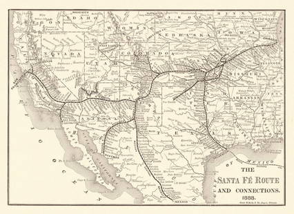
Sold2024Title: Santa Fe Route and Connections. Publication Date: 1888 Cartographer: RAND, MCNALLY & CO.Title: Santa Fe Route and Connections. Publication Date: 1888 Cartographer: RAND, MCNALLY & CO. Publisher: A.T. & S.F. RY CO. Height: 6.8 Width: 9.75 Annual repoprt map. Detailed Reserve: $50.00 ShippSee Sold Price
Sold2018Historic Arizona MapCa. 1888, Early Rand McNally map featuring the state of Arizona, identifying and naming all the counties and pointing out many important landmarks, settlements, etc. Very good condition. Framed and maSee Sold Price
Sold2018Rand McNally Connecticut Rhode Island Map 1888The copyright date on it is 1888. You be the judge. Approx. 14 1/2" x 20See Sold Price
Sold20201888 Map of ArizonaAuthor: McNally Title: 1888 Map of Arizona Medium: Ink on Paper Dimensions: 11"X14" Map of Arizona dated 1888. Published by Rand McNally and Co. in New York. Part of the New Family Atlas of the World.See Sold Price
2023Rand, McNally New Commercial Atlas Map of TexasDescriptionTitle: Rand, McNally New Commercial Atlas Map of TexasPublication Date: c1920-1925Cartographer: RAND, MCNALLY & CO.Publisher: RAND, MCNALLY & CO.Height: 26Width: 37Atlas map to twice naturaSee Sold Price
Sold2023Rand, McNally New Commercial Atlas Map of TexasTitle: Rand, McNally New Commercial Atlas Map of TexasPublication Date: c1920-1925Cartographer: RAND, MCNALLY & CO.Publisher: RAND, MCNALLY & CO.Height: 26Width: 37Atlas map to twice natural size. RaiSee Sold Price
Sold2020The Rand-McNally Standard Atlas of the World 1888Title: The Rand-McNally Standard Atlas of the World 1888 Date: 1888 Materials: Paper Size/ Dimensions: Approx. 11x 14 inches Additional Info: Chicago: The Continental Publishing Co, 1888. Atlas. Good.See Sold Price
Sold2020Missouri, Kansas & Texas Railway and Connections.Publication Date: c1870 Title: Missouri, Kansas & Texas Railway and Connections. Cartographer: RAND, MCNALLY & CO. Publisher: RAND, MCNALLY & CO. Height: 8.25 Width: 11.5 Book illustration map possiblSee Sold Price
Sold2020Rand McNally & Co., County and Railroad Pocket MapRand McNally & Company, Indexed County and Railroad Pocket Map and Shipper's Guide of Texas, Chicago 1904 image size: 24 x 16", frame: 28 x 17.5" Fine separately published map of Texas, colored by couSee Sold Price
Sold20231888-9 RAND McNALLY & CO. INDEXED ATLAS OF THE WORLD maps ANTIQUE FOLIORand, McNally & Co.’s new indexed ATLAS OF THE WORLD Chicago; 1888-89 Massive folio. Size 11 by 14.5" Binding is worn with some damages, covers are detached, spine destroyed. Good interior, someSee Sold Price
Oct 12JM Hobby Supply and Railroad Artifact Auctions1879 Rand McNally Township County and Railroad Map of Illinois$40
12 hrs LeftJasper521894 Rand McNally Map of British Columbia -- Indexed Atlas of the World Map of British Columbia$35
12 hrs LeftJasper52Austria-Hungary Rand, McNally & Co.'S Indexed Atlas of the World Map of Austria-Hungary.$70
12 hrs LeftJasper521901 Rand McNally Map of US West -- New Commersial Map of Denver to Pacific Coast$55
12 hrs LeftJasper52Rand, McNally & Co.'S Indexed Atlas of the World Map of Germany (Western Sheet). | (Eastern Sheet).$60
12 hrs LeftJasper52Rand, McNally & Co.'S Indexed County & Railroad Pocket Map And Shippers' Guide of Kentucky$80


![Rand McNally: Antique Map of Texas, 1894: Title/Content of Map: 1894 Rand McNally Texas [verso] Indian Territory, N Dakota -- Texas [verso] Indian Territory, North Dakota Date Printed: 1894, Chicago Cartographer: Rand McNally Size: 18.3 x 13.](https://p1.liveauctioneers.com/5584/115725/59466797_1_x.jpg?height=310&quality=70&version=1517366277)


![1898 Rand McNally Map of Texas [verso] Indian Territory and Oklahoma -- Texas [verso] Oklahoma and: Title: 1898 Rand McNally Map of Texas [verso] Indian Territory and Oklahoma -- Texas [verso] Oklahoma and Indian Territory Cartographer: Rand McNally Year / Place: 1898, Chicago Map Dimension (in.): 9](https://p1.liveauctioneers.com/5584/329422/177662173_1_x.jpg?height=310&quality=70&version=1715717898)

![1896 Rand McNally Map of Texas and Indian Territory: Title/Content of Map: 1896 Rand McNally Map of Texas and Indian Territory/Oklahoma -- Texas [verso] Oklahoma and Indian Territory Date Printed: 1896 Chicago Cartographer: Rand McNally Size: 9.2 x 12.5](https://p1.liveauctioneers.com/5584/120548/61369196_1_x.jpg?height=310&quality=70&version=1524013707)
![[Texas.] Rand, McNally & Co.'s New 11 X 14 Map of Texas.: Publication Date: ©1901 Title: [Texas.] Rand, McNally & Co.'s New 11 X 14 Map of Texas. Cartographer: Rand, McNally & Co. Publisher: Rand, McNally & Co. Height: 9.25 Width: 12.5 Page 55 from Rand](https://p1.liveauctioneers.com/5584/285598/150695081_1_x.jpg?height=310&quality=70&version=1681855790)
![1911 Rand McNally Map of Texas [verso] Oklahoma -- [Texas] verso [Oklahoma]: Title: 1911 Rand McNally Map of Texas [verso] Oklahoma -- [Texas] verso [Oklahoma] Cartographer: Rand McNally Year / Place: 1911 Chicago Map Dimension (in.): 9.2 X 12.5 in. This is a nice map of Texas](https://p1.liveauctioneers.com/5584/250444/130076930_1_x.jpg?height=310&quality=70&version=1654643749)
![1914 Rand McNally Map of Texas [verso] Oklahoma -- Texas [verso] Oklahoma: Title: 1914 Rand McNally Map of Texas [verso] Oklahoma -- Texas [verso] Oklahoma Cartographer: Rand McNally Year/Place: 1914, Chicago Dimensions: 9.2 X 12.5 in. Description: This is a very nice map of](https://p1.liveauctioneers.com/5584/241996/125442425_1_x.jpg?height=310&quality=70&version=1648585952)


![1891 Rand McNally Oregon [verso] Nevada -- Oregon [verso] Nevada (1 of 2)](https://p1.liveauctioneers.com/5584/343693/186665657_1_x.jpg?height=282&quality=70&version=1726603887)


![Rand-Mcnally Indexed Atlas. [Georgia.] (1 of 1)](https://p1.liveauctioneers.com/5584/343693/186665708_1_x.jpg?height=282&quality=70&version=1726603887)

