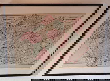
Sold2022Framed 1873 Columbia County MapFramed page from Columbia County Atlas, 1873, showing Malden Bridge, East Chatham, Chatham, Chatham Center, New Concord, and Claverack, 13 3/4" x 16 1/2" framed.See Sold Price
Sold2021Beers & Co 1873 Atlas Columbia County, NY w/ Color Maps1873 Atlas of Columbia County New York, with engravings by Worley & Brocher. First edition hardcover folio with debossed covers and gilt title. Atlas pages have amazingly detailed and colorful hisSee Sold Price
Sold2021Antique Framed Map of Columbia County, NY 1829Antique Framed Map of Columbia County, NY, dated 1829. Engraved by Rawdon Clark & Co, Albany, NY. Also marked Rawdon Wright, New York. Map includes locations of mills, churches and stage roads. NicelySee Sold Price
Sold20213 Antique Columbia County Colored Maps 1873, Hudson NYAntique Lot of Three Columbia County Colored Maps 1873. Maps for Stockport/Stuyvesant Landing, Hudson, and Greenport with plastic covers and cardboard backs. Pink, blue, and yellow colors with detaileSee Sold Price
Sold2021Framed 1850 County of Columbia, NY Map, Wingram Reissue1798 John Wigram map of Columbia County, New York. This is an 1850 reissue. Copy by David Vaughan on May 1850. This is a splendid map showing towns of Livingstone, Germantown and CleSee Sold Price
Sold2022Framed Page from Columbia County Atlas, 1873Framed page from Columbia County Atlas, 1873, showing Malden Bridge, East Chatham, Chatham, Chatham Center, New Concord, and Claverack and showing Claverack business notices of the time and penciled iSee Sold Price
Sold2021Antique Framed Map Livingston,Germantown,Claremont NYAntique Framed Map of Livingston, Germantown and Claremont, Columbia County, NY. Dated 1850. Engraved by R.H.Pease, Albany, NY. Lovely early map is nicely framed in dark brown wood, and wired on the bSee Sold Price
Sold2017Mitchell: Antique County Map of Texas, 1873Excellent 1873 County Map of Texas by S. Augustus Mitchell. Impressive two-page County Map of the State of Texas. Map image much larger than earlier Mitchell maps. Designed and engraved by W. H. GamblSee Sold Price
Sold2024FRAMED WARREN COUNTY MAPWARREN CO., NEW JERSEY. MATTED AND FRAMED UNDER GLASS. 29 1/4" X 21 3/4". PLEASE READ CAREFULLY - Terms for Purchasing and Shipping of Auction Items. Please read carefully before bidding. All paymentsSee Sold Price
Sold20223 FRAMED CHARLESTON COUNTY MAPSThree (3) Framed Charleston County Maps showing Neighborhoods. Includes 1- The Peninsula of Charleston.2- East Cooper; Mt. Pleasant, Isle of Palms, Sullivans Island. 3- Sea Islands; Kiawah, Seabrook,See Sold Price
Sold2021Hall china lot of artwork, signs, displayexhibit, product photos/posters plant drawing of Hall China, Columbia County, Ohio mapSee Sold Price
Sold2021Dolph & Stewart 30s Map Columbia County NY Large FolioMap of Columbia County with Eastern part of Greene County, New York, by Dolph & Stewart, circa 1930s. This is a oversized hardcover bound version of what would be tiles from a large wall-mounted mSee Sold Price
Sold2021Dolph & Stewart 30s Map Columbia County NY Large FolioMap of Columbia County with Northern part of Greene County, New York, by Dolph & Stewart, circa 1930s. This is a oversized hardcover bound version of what would be tiles from a large wall-mountedSee Sold Price
Sold20231876 Atlas of Illinois- Cook County Map Framed PagTravel back in time to the late 19th century with this enchanting Framed Map Page from the 1876 Atlas of Illinois by Warner & Beers. This exquisite piece showcases the detailed cartography of Cook, DuSee Sold Price
Sold2021Large Antique Hanging Map of Columbia County NY 1858Large Antique Hanging Map of Columbia County New York from 1858. Shows details and insets of towns and villages in Columbia county. Has a top piece made to hang on the wall. Has a beautiful patina andSee Sold Price
Sold2022Map of Columbia County, NY, 1858Hanging map of Columbia County, NY, as surveyed by S. N. Beers, D. J. Lake, and F. W. Beers, printed E. A. Balch Publisher, with a highlighted map of the City of Hudson, and less detailed views of ClaSee Sold Price
Sold2022Map of Columbia County, NY, 1933Hanging map of Columbia County, NY, with Eastern part of Greene County, printed by Dolph & Stewart Map Publishers, with more detailed portions of Hudson, Chatham, Athens, and Coxsackie, 49" x 66".See Sold Price
Sold2022FRAMED KENT COUNTY MD TOWN MAPS FROM ATLASALL MAPS FROM THE 1877 KENT COUNTY MD ATLASSee Sold Price
Sold2021Collection of Promenade Hill Hudson,NY Photos & MoreCollection of 16 Historic Hudson NY and Columbia County Photographs, plus newspaper clippings, postcards, pages from books, and a map of Columbia County. Included are Promenade Hill, the Hudson-AthensSee Sold Price
Sold2021Antique 1858 Wall Map of Columbia County,NY New YorkLarge antique c.1858 map of Columbia county New York. This large map has lots of great details. It is perfect for anyone interested in local Hudson Valley history. The dimensions are 57in x 66in x 1.5See Sold Price
Sold2022Vintage 1950 Chas. E. Shannahan Talbot Co. Maryland Mapmeasuring 25" x 28" high framed 1950 Talbot County, Maryland Map mounted on linen with pencil notes written on right hand side. "Seats of Talbot County" #41 of 100 copies made.See Sold Price
Sold20223 David Burr Maps Erie & Niagara County3 David Burr Maps Erie & Niagara County Framed - approx 25" x 21.5"See Sold Price
19 hrs LeftRapid Estate Liquidators and Auction GalleryFramed Collection Engravings & A Map From The Excursions In The County Of Sussex Published In 1822$5
May 26Ararity AuctionsC. G. Reichard "Charte des Osmanische Reichs in Asien" 1804 Antique Hand Colored Framed Map$50
May 29Cedarburg Auction & Appraisals LLCRare 1877 Double sided map of Milwaukee and Wisconsin$35(3 bids)
Featured4 days LeftJasper521878 Mitchell Map of Virginia and West Virginia [verso] New Jersey, Maryland and Delaware -- County$45
5 days LeftThomaston Place Auction GalleriesFRAMED HANDCOLORED MAP OF AUSTRALIA BY JOHNSON & WARD, 1863$150
5 days LeftThomaston Place Auction GalleriesFRAMED HANDCOLORED MAP OF JAPAN BY JOHNSON & WARD, 1863$150
3 hrs LeftRapid Estate Liquidators and Auction GalleryFramed Vintage Map Of Le Port Au Prince In The Island Of Santo Domingo$90
May 31Freeman's | Hindman[CIVIL WAR]. Two letters from mentioning enslaved persons incl. a Confederate soldier's letter from$150


![1878 Mitchell Map of Virginia and West Virginia [verso] New Jersey, Maryland and Delaware -- County (1 of 2)](https://p1.liveauctioneers.com/5584/329422/177662152_1_x.jpg?height=282&quality=70&version=1715717898)


![[CIVIL WAR]. Two letters from mentioning enslaved persons incl. a Confederate soldier's letter from (1 of 1)](https://p1.liveauctioneers.com/197/329785/177758375_1_x.jpg?height=282&quality=70&version=1715625218)

