Sold2023"Atlas Of The Hudson River Valley From New York City To Troy", by F.W. Beers, hand colored maps in"Atlas Of The Hudson River Valley From New York City To Troy", by F.W. Beers, hand colored maps in large folio, published by Watson & Co. New York 1891. Each map page with canvas backing so most map pSee Sold Price
Sold20211891 Large F.W. Beers Atlas of the Hudson River ValleyAtlas of the Hudson River Valley from New York City to Troy, by F.W. Beers, published by Watson and Co, New York, 1891. Oversize hardcover folio format contains incredible map pages with much typograpSee Sold Price
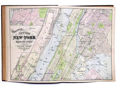
Sold2017ATLAS OF THE HUDSON RIVER VALLEY FROM NEW YORK CITY TOATLAS OF THE HUDSON RIVER VALLEY FROM NEW YORK CITY TO TROY, F.W. BEERS, WATSON & CO., 1891 (COMPLETE) "PRESENTED TO THE HUDSON RIVER LODGE NO.607, COMPLIMENTS OF BROS. G.H. & G.E. JACOBS, NEWBURGH NYSee Sold Price
Sold2023"Atlas of Columbia Co. New York" by F.W. Beers, published in 1873. The book is complete with all"Atlas of Columbia Co. New York" by F.W. Beers, published in 1873. The book is complete with all hand colored maps - wear to binding and covers but overall it is in very good condition. The book measuSee Sold Price
Sold2023Antique Hand Colored Maps of Westchester County NYAntique Hand Colored Maps of Westchester County NY. This lot includes four 19th century hand colored maps from the "Atlas of New York and Vicinity" by F.W. Beers. Includes one map of Bedford, one mapSee Sold Price
Sold2018Antique Hand Colored Maps of Westchester County NYAntique Hand Colored Maps of Westchester County NY. This lot includes four 19th century hand colored maps from the "Atlas of New York and Vicinity" by F.W. Beers. Includes one map of Mamaroneck/Rye NeSee Sold Price
Sold2018Antique Hand Colored Maps of Westchester County NYAntique Hand Colored Maps of Westchester County NY. This lot includes four 19th century hand colored maps from the "Atlas of New York and Vicinity" by F.W. Beers. Includes one map of Bedford, one mapSee Sold Price
Sold2018Antique Hand Colored Maps of Westchester County NYAntique Hand Colored Maps of Westchester County NY. This lot includes four 19th century hand colored maps from the "Atlas of New York and Vicinity" by F.W. Beers and the Planning Board/Technical AdvisSee Sold Price
Sold2018Antique Hand Colored Maps of Westchester County NYAntique Hand Colored Maps of Westchester County NY. This lot includes four 19th century hand colored maps from the "Atlas of New York and Vicinity" by F.W. Beers. Includes one map of Port Chester, oneSee Sold Price
Sold2018Antique Hand Colored Maps of Dutchess County, NY.Antique Hand Colored Maps of Dutchess County, NY. This lot includes three 19th century hand colored maps from the "Atlas of New York and Vicinity" by F.W. Beers. Includes one map of Hyde Park, one mapSee Sold Price
Sold2018Antique Hand Colored Maps of Westchester County NYAntique Hand Colored Maps of Westchester County NY. This lot includes three 19th century hand colored maps including two from F.W. Beers "Atlas of New York and Vicinity" and one unmarked. Includes oneSee Sold Price
Sold2015(3) 19th c. hand colored maps of ConnecticutGrouping of three circa 1867 hand colored maps from the "Atlas of New York and Vicinity" by Beers, Ellis & Soule, the drawings based on land surveys performed under the direction of F.W. Beers, includSee Sold Price
Sold2016Atlas of New York and Vicinity by F.W. Beers 1867Atlas of New York and Vicinity by F.W. Beers 1867; gilt letter are worn; last page (which is blank) is ripped, the atlas is complete, has 44 pages with many fold out maps including Sing Sing, DutchessSee Sold Price
Sold2023(3) EARLY 19TH C. FRENCH HAND COLORED LITHOS OF THE HUDSON RIVER VALLEY, NEW YORKIncluding: "Chutes de l'Hudson, au village de Gleens"; "Moulins pres de Luzerne aux sources de l'Hudson"; "Chute interieure pres l'habitation de Madme. Montgomery", artist unknown, circa 1925, the firSee Sold Price
Sold2016(3) 19th c. hand colored maps of ConnecticutGrouping of three circa 1867 hand colored maps and one black and white advertisement from the "Atlas of New York and Vicinity" by Beers, Ellis & Soule, the drawings based on land surveys performed undSee Sold Price
2022Advertising poster, Jacob Ruppert's KnickerbockerAdvertising poster, Jacob Ruppert's Knickerbocker Beer", New York City map, comes in the original shipping cylinder, 21" by 28.75", on canvas.See Sold Price
Sold2021(NEW JERSEY.) F.W. Beers. State Atlas of New Jersey.(NEW JERSEY.) F.W. Beers. State Atlas of New Jersey. 118 (of 122) pages containing a profusion of hand-colored lithographed maps (lacking double-page map of Bergen and Passaic counties and full-page mSee Sold Price
Sold20222 maps, colonial New York & North America, New York2 maps, colonial New York & North America, New York City, North River, Hudson Valley, "for D1, Valentine's Manual, for 1860, 13' by 10" & map of North America, United States, with various illustrationSee Sold Price
Sold2022Six Atlas of New York and Vicinity, hand colored engraved maps including Sommers, Patterson,Six Atlas of New York and Vicinity, hand colored engraved maps including Sommers, Patterson, Wakefield, Ossining, City Island, and North Salem, 16 3/4" x 13 3/4". Provenance: Originally from Credit SuSee Sold Price
Sold2021(NEW YORK--LONG ISLAND.) F.W. Beers. Atlas of Long(NEW YORK--LONG ISLAND.) F.W. Beers. Atlas of Long Island, New York. Profusion of hand-colored lithographed mapsheets, several folding (complete). Folio, 16x13 inches, publisher's morocco backed gilt-See Sold Price
Sold2018Currier hand colored lithograph, "A View of the FederalCurrier hand colored lithograph, "A View of the Federal Hall of the City Of New York, as appeared in the year 1797", from the original drawing by George Holland, 18.5" by 24", tears in margins, some pSee Sold Price
Sold2023View of Newburgh - William Guy WallView of Newburgh [New York] Beautifully Hand Colored. The engraving "View of Newburgh" is a beautiful example of Wall's work. It depicts the city of Newburgh, New York, from across the Hudson River. TSee Sold Price
Sold2022(NEW YORK CITY.) G. W. Bromley & Co. Atlas of the City of New York - Borough of Manhattan. Volumes 2(NEW YORK CITY.) G. W. Bromley & Co. Atlas of the City of New York - Borough of Manhattan. Volumes 2 and 3. Volume 2, 14th Street to 59th Street: Index map and 45 hand-colored double-page lithographedSee Sold Price
Sold2021State Atlas of New Jersey, Beers Comstock & Cline,State Atlas of New Jersey, Beers Comstock & Cline, 1872, "By and Under the Direction of F.W. Beers, some loss bottom spine, some maps have tears, structurally good.See Sold Price
5 days LeftCollective HudsonBalthasar Frederich Lazelt Colored Engraving Print Of Lower Manhattan Harbor Entrance Published 1775$200


![View of Newburgh - William Guy Wall: View of Newburgh [New York] Beautifully Hand Colored. The engraving "View of Newburgh" is a beautiful example of Wall's work. It depicts the city of Newburgh, New York, from across the Hudson River. T](https://p1.liveauctioneers.com/5614/294993/156626369_1_x.jpg?height=310&quality=70&version=1688581746)


