Sold20231887 Bradley map of Quebec -- Map of Quebec in CountiesTitle: 1887 Bradley map of Quebec -- Map of Quebec in Counties Cartographer: W Bradley Year / Place: 1886, Philadelphia Map Dimension (in.): 10.5 X 13.4 in. This is an excellent map of Quebec along thSee Sold Price
Sold20211887 Map of Quebec CityAuthor: Watson Title: 1887 Map of Quebec City Medium: Ink on Paper Dimensions: 14.5"X11.5" Map of Quebec City, dated 1887. Engraved for Watson's General Atlas. Double folio map. Reference key locatedSee Sold Price
Sold20201887 Map of Quebec cityTitle: 1887 Map of Quebec city Author: Watson Medium: Ink on Paper Dimensions: 14.5"X11.5" Description: Map of Quebec city dated 1887. Part of Watson's Standard Atlas of the World. Map key located uppSee Sold Price
Sold2018Mitchell: County Map of Quebec/Montreal InsetCartographer: S. A. Mitchell Place/Date: Philadelphia / 1870 Size: 13 1/4" x 10 3/4" Condition: full color; light overall age toning The beautifully detailed and colored county map of Quebec from theSee Sold Price
Sold20191886 California from Mitchell atlasFine antique lithograph map with original hand color. “County Map of the State of California” by William Bradley and found in the 1887 Mitchell New General Atlas. Detailed, scarce and interestingSee Sold Price
Sold2018Tallis/Rapkin: Antique Map East Canada & New BrunswickTitle/Content of Map: 'East Canada and New Brunswick' The map shows the southern part of Quebec and New Brunswick, in districts/counties. Vignettes: North American Indians; Quebec City Date Printed: 1See Sold Price
Sold2017Tallis/ Rapkin: Antique Map East Canada, New BrunswickTitle/Content of Map: 'East Canada and New Brunswick' The map shows the southern part of Quebec and New Brunswick, in districts/counties. Vignettes: North American Indians; Quebec Date Printed: 1851 ISee Sold Price
Sold2019EAST CANADA & NEW BRUNSWICK. Quebec. Québec city view.TITLE/CONTENT OF MAP: 'East Canada and New Brunswick' The map shows the southern part of Quebec and New Brunswick, in districts/counties. Vignettes: North American Indians; Quebec The top image on theSee Sold Price
Sold2019Automobile Green Book 1931 Eastern StatesAutomobile Green Book 1931-1932 All States East of Mississippi River Eastern Ontario, Quebec and Maritime Provinces. Ads. Folding Maps are present in rear pocketSee Sold Price
Sold2023Collection of 4 Antique Maps: Quebec St. Lawrent, Ville De Louisbourg.Collection of 4 Antique Maps: Quebec St. Lawrent, Ville De Louisbourg.See Sold Price
Sold2024[CANADA, ETC.] LOT OF 35 PIECES SOLD TOGETHERCANADA, etc. A lot of approximately 35 pieces sold together. Late 19th to mid 20th century, dates vary. Condition and sizes vary. Including: maps (Quebec, 1966 TTC, Regina, Manitoba, larger map of YukSee Sold Price
Sold2021Quebec 1903Title/Content of Map: Quebec 1903 Date Printed: 1903 Material/Medium: paper Size: approx. 10x 13 inches Peerless Atlas Pictorial Gazetteer. The Crowell Publishing Co., Springfield OH Reserve: $30.00 SSee Sold Price
Sold2018Mitchell: Antique Map of Quebec, 1869Title/Content of Map: Quebec by Mitchell Date Printed: 1869 Cartographer: Augustus S. Mitchell Size: 14" x 16" Material/Medium: Paper Provenance: New York Published in Philadelphia in 'Mitchell's NewSee Sold Price
Sold2017Hardesty Quebec MapMap of Quebec, Hardesty, 1883, 20.75 x 14.5 in Please note that this lot has a confidential reserve. When you leave a bid in advance of the auction, submit your maximum. Jasper52 will bid on your behaSee Sold Price
Sold2019Carte du cours du fleuve de St Laurent' St LawrenceTITLE/CONTENT OF MAP: 'Carte du cours du fleuve de St Laurent, depuis sont embouchure jusqu'au dessus de Québec [Map of the course of the St Lawrence river from its mouth to above Quebec]' DATE PRINTSee Sold Price
Sold2023Hand Colored Map of QuebecDated 1759. Stains, losses, glued down. 15-1/2"h x 18-1/4"w Provenance: Property from the Collection of Maggie Cohen, New York CitySee Sold Price
Sold20171759 Magazine French Indian War Map of Quebec1759 Magazine French Indian War Map of Quebec. The October 1759 issue of Gentleman's Magazine, printed in London, 54 pages. INCLUDES the exact map of the "Isle of Orleans and the Country Round Quebec"See Sold Price
Sold2017Mitchell: Antique Map of Quebec, 1877Title: Map of Quebec by Mitchell Date: 1877 Medium: Hand Colored Lithograph Dimensions (in.): 15.2 x 12.2 Samuel Augustus Mitchell (1790-1860) was an American geographer born in Connecticut. He workedSee Sold Price
Sold2017Map of Quebec, Rand, McNally & Co. 1898Map: Quebec Rand, McNally & Co. 1898 New Standard Atlas of the World 28 x 21.5 inches Please note that this lot has a confidential reserve. When you leave a bid in advance of the auction, submit yourSee Sold Price
Sold20211883 Mitchell/Bradley Map of Florida -- County Map ofTitle: 1883 Mitchell/Bradley Map of Florida -- County Map of Florida Cartographer: Mitchell / Bradley Year / Place: 1883, Philadelphia Map Dimension (in.): 10.5 X 14.4 in. This is a rather handsome coSee Sold Price
Sold2021Foley China Cup and Saucer, Sherbrooke QuebecBeautiful gold rim; Map of Quebec; White, green, blue and pink. The Foley China backstamp. Issued: 20th c. Dimensions: 2.75"H x 4" dia. Manufacturer: The Foley Cup Country of Origin: EnglandSee Sold Price
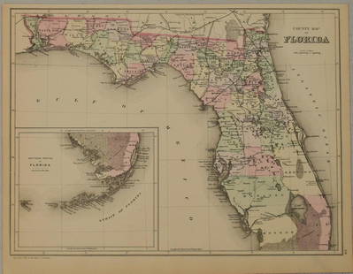
Sold20181887 Mitchell Map of Florida -- County Map of FloridaTitle/Content of Map: 1887 Mitchell Map of Florida -- County Map of Florida Date: 1887, Philadelphia Cartographer: S Mitchell Size: 10.7 X 14.3 in. Handsome county map of Florida. In this derivative mSee Sold Price
Sold2023Jefferys, Authentic Plan of the River St. Laurence - First StateJEFFERYS, Thomas (c. 1719 - 1771). An Authentic Plan of the River St. Laurence from Silleru to the Fall of Montmorenci with the operations of the Siege of Quebec... Engraved map with original hand colSee Sold Price
Sold2017Bellin: Antique Map of Saint Lawrence River, 1764Title/Content of Map: 'Cours du Fleuve de Saint Laurent depuis la mer jusqu'à Quebec [Course of the Saint Lawrence river from the sea to the city of Quebec]' A map of the St Lawrence river estuary anSee Sold Price
Jun 08Early American History Auctions1776 Map, PARTIE ORIENTALE DU CANADA, AVEC LA NOUVELLE ANGLETERRE, L'ACADIE... by P. Santini, Framed$950
Featured1 day LeftJasper521878 Mitchell Map of Virginia and West Virginia [verso] New Jersey, Maryland and Delaware -- County$45
1 day LeftJasper521892 Cowles Civil War Map of Battles in Gettysburg, Virginia, W Virginia and Maryland -- Sketch of$55(1 bid)
Featured1 day LeftJasper52Railroad Map of the United States Showing the Through Lines of Communication...$50
Featured1 day LeftJasper52Index Map to the Charts Published by the U.S. Coast and Geodetic Survey Gulf Coast Cape San Blas to$50
1 day LeftJasper521878 Mitchell Map of Washington, Oregon, Idaho, much of Montana [verso] Territory of Idaho$55
Jun 23Treasure Quest AuctionsPr. Child's Ulster County, NY 1871-72 Gazetteer & Business Directories$50
Jun 07Freeman's | HindmanMURCHISON, Roderick Impey, Sir. The Silurian System. 1839. COMPLETE WITH VERY RARE HAND-COLORED$1,500


![[CANADA, ETC.] LOT OF 35 PIECES SOLD TOGETHER: CANADA, etc. A lot of approximately 35 pieces sold together. Late 19th to mid 20th century, dates vary. Condition and sizes vary. Including: maps (Quebec, 1966 TTC, Regina, Manitoba, larger map of Yuk](https://p1.liveauctioneers.com/8124/322212/173234988_1_x.jpg?height=310&quality=70&version=1709937662)


![Carte du cours du fleuve de St Laurent' St Lawrence: TITLE/CONTENT OF MAP: 'Carte du cours du fleuve de St Laurent, depuis sont embouchure jusqu'au dessus de Québec [Map of the course of the St Lawrence river from its mouth to above Quebec]' DATE PRINT](https://p1.liveauctioneers.com/5584/144578/73088287_1_x.jpg?height=310&quality=70&version=1561513819)


![Bellin: Antique Map of Saint Lawrence River, 1764: Title/Content of Map: 'Cours du Fleuve de Saint Laurent depuis la mer jusqu'à Quebec [Course of the Saint Lawrence river from the sea to the city of Quebec]' A map of the St Lawrence river estuary an](https://p1.liveauctioneers.com/5584/110975/56961948_1_x.jpg?height=310&quality=70&version=1508432804)


![1878 Mitchell Map of Virginia and West Virginia [verso] New Jersey, Maryland and Delaware -- County (1 of 2)](https://p1.liveauctioneers.com/5584/329422/177662152_1_x.jpg?height=282&quality=70&version=1715717898)


![1878 Mitchell Map of Washington, Oregon, Idaho, much of Montana [verso] Territory of Idaho (1 of 2)](https://p1.liveauctioneers.com/5584/329422/177662232_1_x.jpg?height=282&quality=70&version=1715717898)


![Untitled. Midwest. [Map Issued With the Official Inter-State Railway Guide] (1 of 1)](https://p1.liveauctioneers.com/5584/329422/177662238_1_x.jpg?height=282&quality=70&version=1715717898)


