2017Tallis/Rapkin: Antique Map of Captain Cook's VoyageTitle/Content of Map: 'The World on Mercator's Projection shewing the voyages of Captain Cook around the World' The track's of Cook's first, second and third voyages are shown, along with dates. DateSee Sold Price
Sold2018Africa from the Best Authorities.Title/Content of Map: Africa from the Best Authorities. Date: 1790 Cartographer: KITCHIN, T. Size: 7.25X8.8 Illustration map from Guthrie's Geography. Rather detailed. Polar projection Please note thaSee Sold Price
Sold2022MAP "THE WORLD ON MERCATOR'S PROJECTION SHEWING THE VOYAGE OF CAPTAIN COOK ROUND THE WORLD." CircaMAP "THE WORLD ON MERCATOR'S PROJECTION SHEWING THE VOYAGE OF CAPTAIN COOK ROUND THE WORLD."Circa 1800Published by The London Printing and Publishing Company. Engraved for R. Montgomery MartSee Sold Price
Sold2017Chart of the World On Mercators Projection, 1796Map: Chart of the World On Mercators Projection Maker: Thomas & Andrews, Morse/Doolittle (Sculp) Publisher: Boston, 1796 Size: Quarto - 7.30 H x 10.00 W Inches Small map of the world. Shows LouisianaSee Sold Price
Sold2017Jefferys: Antique Map of Europe, 1763Map: Europe. Publication Date: 1763 ca. Authors: JEFFERYS, T. Size: Octavo – 7.10 H x 8.80 W Inches T. Jefferys, Sc. On polar projection Thomas Jefferys (1719-1771) was the Royal Cartographer tSee Sold Price
Sold2017Russell: Antique Map of Europe, 1794Map: A Map of Europe Agreeable to the Latest Authorities Publication Date: 1794 ca. Authors: RUSSELL, sc. Size: Octavo – 7.10 H x 8.80 W Inches Polar projection. Later coloring. Browned. Top and botSee Sold Price
Sold2017Russell: Antique Map of Northern Russia, 1794Map: The Northern Part of Russia, Or, Muscovy in Europe Publication Date: 1794 ca. Authors: RUSSELL, sc. Size: Octavo – 7.60 H x 8.60 W Inches Polar projection. Modern coloring.Top margin trimmSee Sold Price
Sold2023General Chart on Mercators Projection. World. Cook's route. PAYNE 1798 old mapTITLE/CONTENT OF MAP: 'General Chart on Mercators Projection' DATE PRINTED: 1798 IMAGE SIZE: Approx 18.0 x 25.0cm, 7 x 9.75 inches (Medium) TYPE: Antique copperplate engraved map with original hand coSee Sold Price
Sold2018Africa, from the Best Authorities.Title/Content of Map: Africa, from the Best Authorities. Date Printed: 1806-01-01 Cartographer: BARLOW, J. sculp. Size: 7.25x8.1 Polar projection. From Rev. E. Blomfield's geography, A general view ofSee Sold Price
Sold2018Asia from the Best AuthoritiesTitle/Content of Map: Asia from the Best Authorities Date Printed: 1794 ca. Cartographer: RUSSELL, sc. Size: 7.5x9.1 Polar projection. Later coloring. Browned. Please note that this lot has a confidenSee Sold Price
Sold2018Asia from the Latest Authorities.Title/Content of Map: Asia from the Latest Authorities. Date: 1807 Cartographer: BARLOW, J. sculp. Size: 7.3X8.75 Polar projection. From Rev. E. Blomfield's geography, A general view of the world. LowSee Sold Price
Sold20241842 VOYAGES OF CAPTAIN JAMES COOK 2 VOLUMES antique ILLUSTRATEDThe Voyages of Captain James Cook London: William Smith, 1842 2 volumes Size 7 by 9 3/4" Additional engraved title in volume I, engraved frontispieces, double-page maps, in-text vignettes, etc. MinorSee Sold Price
Sold2023Wright, Thomas 1852 Portrait Print. Captain James Cook, AustraliaSteel Engraved Map Published 1852-56, London for "The Universal Pronouncing Dictionary" by Thomas Wright. Paper Size: 10.5 x 7 inch (27 x 18cm) Margin toning and staining present. Image fineSee Sold Price
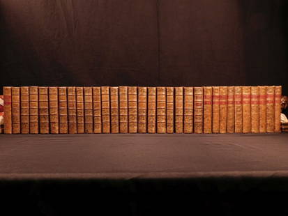
Sold20181780 1ed RARE Complete VOYAGES Maps Captain Cook Americ1780 1ed RARE Complete VOYAGES Maps Captain Cook America Explorers Africa 32v The best book of its kind! An extremely rare, 32-volume complete set of La Harpe’s ‘General History of Voyages’! ThiSee Sold Price
Sold20181780 1ed RARE Complete VOYAGES Maps Captain Cook1780 1ed RARE Complete VOYAGES Maps Captain Cook America Explorers Africa 32v The best book of its kind! An extremely rare, 32-volume complete set of La Harpe’s ‘General History of Voyages’! ThiSee Sold Price
Sold20221836 1ed Oceania Rienzi Polynesia Voyages MAPS Australia Captain Cook Pacific1836 1ed Oceania Rienzi Polynesia Voyages MAPS Australia Captain Cook Pacific Louis de Rienzi was a 19th-century French voyager who is remembered for his 1836 masterwork Oceania, or Fifth Part of theSee Sold Price
Sold20231856 World Map on Polar Projection with Antarctica Explorations by MitchellTitle: 1856 World Map on Polar Projection with Antarctica Explorations by Mitchell Date/Period: 1856 Materials: Hand colored steel engraving Size: 11 1/2” x 9” Discover the world as it wasSee Sold Price
Sold2022c. 1781 Captain Cook Voyages Map, London by Alexander HoggHistoric Maps "A Plan of Success Bay in Strait Le Maire / A Chart of the S.E. part of Terra del Fuego... by Captn. Cook 1769" c. 1781, A "Dual" Map from Captain Cook's Voyages, titled: "A Plan of SuccSee Sold Price
Sold2022c. 1781 Captain Cook Voyages Map, London by Alexander HoggHistoric Maps "A Plan of Success Bay in Strait Le Maire / A Chart of the S.E. part of Terra del Fuego... by Captn. Cook 1769" c. 1781, Dual Map from Captain Cook's Voyages, titled: "A Plan of SuccessSee Sold Price
Sold20191836 1ed Oceania Rienzi Polynesia Voyages MAPS1836 1ed Oceania Rienzi Polynesia Voyages MAPS Australia Captain Cook Pacific Louis de Rienzi was a 19th-century French voyager who is remembered for his 1836 masterwork ‘Oceania, or Fifth Part of tSee Sold Price
Sold2019Russian Empire in Europe and Asia.Title/Content of Map: Russian Empire in Europe and Asia. Date: 1795 Size: 8.3Height - 10.8Width Attractive encyclopedia (?) map. Detailed. Polar projection. Reserve: $60.00 Shipping: Domestic: Flat-raSee Sold Price
Sold2019South AmericaTitle: South America Prublication Date: 1771 Cartographer: PHINN, T. Size: 7Height - 8.75Width Additional Information: Book illustration map with polar projection. Cartouche lower left shows two colonSee Sold Price
Sold2018Russia in EuropeTitle/Content of Map: Russia in Europe Date: 1840 Cartographer: GREENLEAF, JEREMIAH Size: 12.6x10.8 Map on polar projection. Few spots. Please note that this lot has a confidential reserve. When you lSee Sold Price
Sold20181780 1ed VOYAGES Captain Cook Maps Comm Byron America1780 1ed VOYAGES Captain Cook Maps Comm Byron America Explorers Africa 3v La Harpe The best book of its kind! A rare set of La Harpe’s ‘General History of Voyages’! This extensive work was begunSee Sold Price
5 days LeftHunt and Peck Estate Services, Inc.1784 Captain James Cook "A Voyage to the Pacific Ocean" 2 of 3 volumes$360(2 bids)
May 14Hermann Historica GmbHA small porcelain polar bear after a model by Otto Jarl from 1903, Meissen, 2nd half of the 20th€380
3 hrs LeftTrillium Antique Prints & Rare BooksWebber & Cook, Rare - View in the Island of Cracatoa$500