Sold2022Vintage Map Print - Map of the World - Africa - Europe - Australia - 1972Title: Vintage Map Print - Map of the World - Africa - Europe - Australia - 1972 Description: A wonderful lithographic map from a magazine National Geographic. National Geographic has been publishingSee Sold Price
Sold2022Vintage Map Print - Europe -The Historic Mediterranean - Italy - Greece - 1982Title: Vintage Map Print - Europe -The Historic Mediterranean - Italy - Greece - 1982 Description: A wonderful lithographic map from a magazine National Geographic. National Geographic has been publisSee Sold Price
Sold2017Collection of 35 vintage mapsCollection of 35 vintage maps mostly from The National Geographic Magazine including Northern Africa; The Philippines; The Top of the World; Scandinavia; Northern Europe; Southwestern United States; JSee Sold Price
Sold2019ASSEMBLED LOT OF VINTAGE MAPSASSEMBLED LOT OF VINTAGE MAPS: Maps of the east coast, National Geographic maps, AAA road maps, 6 1/4" X 10 1/2" $40 - $80 Shipping:See Sold Price
Sold2018Vintage Maps110+ Assorted California Maps; 50+ Assorted USA and World Maps; 25+ national Geographic Magazine Maps; 1950s -60s Classic Artistic. Road Maps of the Western States; 7Union Oil; Chevron Oil; Shell Oil;See Sold Price
Sold2019Vintage National Geographic Magazine's Map of Mexico,Description: Vintage paper map from National Geographic Magazine, depicting Mexico, Central America & the West Indies. Copyright 1939. Material: paper. Measurement: approximate 33"h x 40"w (INCHES). SSee Sold Price
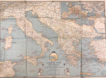
Sold2020Vintage National Geographic MagazineDescription: Vintage paper map from National Geographic Magazine, depicting the classical lands of the Mediterranean. Copyright 1940. Material: paper. Measurement: approximate 26.5"h x 34"w (INCHES).See Sold Price
Sold2022Vintage Discovery, Map, EphemeraThis lot consists of 1 postcard autographed by George Wallace, 4 invitation letters to the Space Shuttle Columbia liftoff in 1986, 1 $2 bill, various National Geographic maps (approx 30) and 3 AfricanSee Sold Price
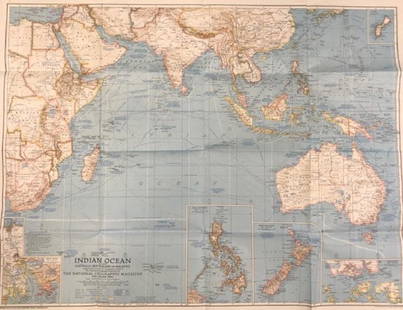
Sold2020Vintage National Geographic Magazine map of the IndianDescription: Vintage color paper map from National Geographic Magazine depicting the Indian Ocean. Copyright 1941. Material: paper. Measurement: approximate 26.5"h x 34"w (INCHES). Shipping cost: $12;See Sold Price
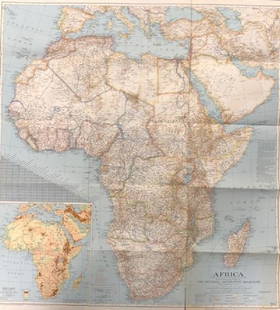
Sold2020Vintage National Geographic Map of AfricaDescription: Vintage color paper map from National Geographic Magazine depicts Africa. Some tearing on bottom. Map is copyrighted from 1943. Material: paper. Measurement: approximate 26.5"h x 34"w (INSee Sold Price
Sold2020(44)Vintage National Geographic Maps - Asst Regions(44)Vintage National Geographic Maps - Asst RegionsSee Sold Price
Sold2023Collection of Ledoux's Maps and CatalogsA collection of 6 maps and catalogs: "Winge's Turistkart over Norge", Map of Norway 1939. The National Geographic Society, Map of The United States 1946. The National Geographic Society, Map of EuropeSee Sold Price
Sold20201939 Nat Geo WWII Eve Map of Europe and theTitle/Content of Map: 1939 Nat Geo WWII Eve Map of Europe and the Mediterranean -- Central Europe and the Mediterranean as of September 1, 1939 Cartographer: National Geographic Society Year/Place: 19See Sold Price
Sold2017MAP - Europe And The Near East - 33 x 39 – 1940Description: “Europe And The Near East” Map compiled and drawn – The National Geographic Society for The National Geographic Magazine- Gilbert Grosvenor, Editor. 33 x 39. Condition: Very Good.ShSee Sold Price
Sold2022Map of Europe Showing Countries As Established at the Peace Conference at ParisPublication Date: c1920 Title: Map of Europe Showing Countries As Established at the Peace Conference at Paris Cartographer: NATIONAL GEOGRAPHIC SOCIETY Publisher: THE NATIONAL GEOGRAPHIC SOCIETY HeigSee Sold Price
Sold2017Central Europe The Mediterranean Map 36 x 26 – 1939Description: “Central Europe The Mediterranean” Map compiled and drawn – The National Geographic Society for The National Geographic Magazine- Gilbert Grosvenor, Editor. 36” x 26”. Year: 193See Sold Price
Sold202140 +/- 1940's-1970's Nat'l Geographic Maps40 +/- National Geographic maps, from 1949-1979, includes Europe and The Near East with Russian and Polish boundaries according to treaties and claims as of April 1, 1949, post-World War II, ClassicalSee Sold Price
Sold2022(18) NATIONAL GEOGRAPHIC MAPS, c.1930s-1940s(lot of 18) National Geographic Maps, world maps dated late 1930s to 1940s, with many notes, mileage, and more, housed in book-form album, approx 10.75"h, 7.5"w, 2.25"d, 3.25lbs Start Price: $40.00See Sold Price
Sold2017National Geographic Map of Southwestern US Map, 1940The Southwestern United States map in the National Geographic Magazine dated June 1940. Measurement approximate: 26” x 35”. Condition: Very Good No Reserve: This lot starts at $1 and has no reservSee Sold Price
Sold2023HOLY ROMAN EMPIRE. Europe in 1360 1902 old antique vintage map plan chartTITLE/CONTENT OF MAP: 'Europe in 1360' DATE PRINTED: 1902 IMAGE SIZE: Approx 25.0 x 33.5cm, 10 x 13.25 inches (Large) TYPE: Antique colour map. This map was published in 1902 but it may depict an earlSee Sold Price
Sold2024Europe by Arrowsmith & Lewis 1812 old antique vintage map plan chartTITLE/CONTENT OF MAP: 'Europe' DATE PRINTED: 1812 IMAGE SIZE: Approx 25.0 x 20.0cm, 9.75 x 8 inches (Medium) TYPE: Antique steel engraved map CONDITION: Good; suitable for framing. Please check the scSee Sold Price
Sold2021HUNDREDS Nautical, Geology & World Geography MapsAn historical estate collection consisting of hundreds of individual maps and charts, produced by and for various sources. Includes original U.S. Geological Survey maps, National Geographic Society woSee Sold Price
Sold20172 HARD BOUND COFFEE TABLE BOOKS2 HARD BOUND COFFEE TABLE BOOKS - BIRDS OF PREY OF THE WORLD - 70 FULL COLOR ILLISTRUTIONS - 283 DUO TONES - 646 SILHOUTTES - 425 RANGE MAPS - NATIONAL GEOGRAPHIC ATLAS OF THE WORLD 8TH EDITION - COMESee Sold Price
Sold2023L'Europe. Europe. BONNE 1780 old antique vintage map plan chartTITLE/CONTENT OF MAP: 'L'Europe' A map of Europe DATE PRINTED: 1780 IMAGE SIZE: Approx 23.0 x 34.0cm, 9 x 13.5 inches (Large); Please note that this is a folding map. TYPE: Antique copperplate engraveSee Sold Price
Jun 20The Ross Art GroupOriginal Vintage Chocolat Menier Le Tour de Monde Poster by Jannot 1956 Chocolate Map$500
Jun 20The Ross Art GroupOriginal Vintage Fly TWA Jets India Pink Elephant Poster by David Klein c1960$600(1 bid)
Jun 20The Ross Art GroupOriginal Vintage Air France World Route Map Vickers Viscount Poster 1956 Constellation$600
2 days LeftAntiques Online AuctionsVintage Texas 1845 Map Printed in 1986, Compiled by John Davis$60(4 bids)