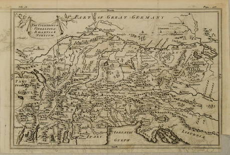
Sold2023Sale & Psalmanazar C1750 Map. The Countries of Vindelicia, Rhaetia & NoricumCopper Engraved Map Published 1747-68, London for "An Universal history, from the earliest account of time..." by George Sale, George Psalmanazar et al. Paper Size: 12.5 x 8 inch (32 x 20cm) Good CondSee Sold Price
Sold2023Sale & Psalmanazar C1750 Map. Indelicia, Rhaetia & Noricum"The Countries of Vindelicia, Rhaetia & Noricum" Copper Plate Published 1747-68, London for "An Universal history, from the earliest account of time..." by George Sale, George Psalmanazar et al. PaperSee Sold Price
Sold20201750 c. Map of Eastern Alps Region in Ancient Times --Title: 1750 c. Map of Eastern Alps Region in Ancient Times -- The Countries of Vindelicia, Rhaethia & Noricum Cartographer: G Sale et al Year/Place: 1750 c., London Size: 7.8 X 11.8 in. Additional InfSee Sold Price
Sold2023Sale & Psalmanazar C1750 Map. Pannonia Moesia Davia and Illyricum Turkey GreeceCopper Plate Published 1747-68, London for "An Universal history, from the earliest account of time..." by George Sale, George Psalmanazar et al. Paper Size: 12.5 x 8 inch (32 x 20cm) Good ConditionSee Sold Price
Sold2023Sale & Psalmanazar C1750 Map. Retreat of the ten thousand Greeks XenophonCopper Plate Published 1747-68, London for "An Universal history, from the earliest account of time..." by George Sale, George Psalmanazar et al. Paper Size: 12.5 x 9 inch (32 x 23cm) Good ConditionSee Sold Price
Sold2023Sale & Psalmanazar C1750 Map. Syria after ye death of Alexander the GreatCopper Plate Published 1747-68, London for "An Universal history, from the earliest account of time..." by George Sale, George Psalmanazar et al. Paper Size: 12.5 x 8.5 inch (32 x 22cm) Good ConditionSee Sold Price
Sold2023Sale & Psalmanazar C1750 Map. Arabia Petraea and DesertaCopper Plate Published 1747-68, London for "An Universal history, from the earliest account of time..." by George Sale, George Psalmanazar et al. Paper Size: 13 x 8.5 inch (33 x 22cm) Some text offsetSee Sold Price
Sold2023Sale & Psalmanazar C1750 Map. Mavretania, Numidia, Gaetulia &c. N. AfricaCopper Plate Published 1747-68, London for "An Universal history, from the earliest account of time..." by George Sale, George Psalmanazar et al. Paper Size: 12.5 x 9 inch (32 x 23cm) Very minor toninSee Sold Price
Sold2023Sale & Psalmanazar C1750 Map. Libya interior, Garamantum et MelanogaetulorumCopper Plate Published 1747-68, London for "An Universal history, from the earliest account of time..." by George Sale, George Psalmanazar et al. Paper Size: 13 x 9.5 inch (33 x 24cm) Very minor offseSee Sold Price
Sold2022San Mateo Co., Cal., Tide Lands at auction 1871Heading: (California - San Mateo County) Author: Allardt, Geo. F., Surveyor Title: Sale Map No. 9. Salt Marsh and Tide Lands situate in the County of San Mateo, State of California. To be sold at publSee Sold Price
Sold202118th Century Portrait18th Century Portrait of a child with dog, holding a riding crop. Recently cleaned. Birdseye maple frame. Canvas 37" X 24". Overall frame size 40 1/2" X 28"See Sold Price
Sold2021Dog Heads Pub Table 19th C.Unusual 4 dog heads pub table. Antique iron strappings & braces. Origin unknown. Height 41", glass top 33" in diameter, legs are 39" X 25"See Sold Price
Sold2022CHINA - SHANGHAI WATERS (THOMAS JAMES) Map of the Country Around Shanghai. Compiled from the Bes...CHINA - SHANGHAI WATERS (THOMAS JAMES) Map of the Country Around Shanghai. Compiled from the Best Authorities with Numerous Additions from Actual Survey, large lithographed map, dissected into 20 secSee Sold Price
Sold2022DARBY, WILLIAM Memoir on the Geography, and Natural and Civil History of Florida, Attended by a MapDARBY, WILLIAM Memoir on the Geography, and Natural and Civil History of Florida, Attended by a Map of That Country, Connected With the Adjacent Places and an Appendix, Containing the Treaty of CessioSee Sold Price
Sold2020RAND, MCNALLY & CO.'s INDEXED ATLAS of the WORLDPublication Date: 1884 Title: RAND, MCNALLY & CO.'s INDEXED ATLAS of the WORLD Primary Authors: RAND, MCNALLY & CO Publisher: RAND, MCNALLY & CO containing large scale maps of every country and civilSee Sold Price
Sold2018[ATLASES].* [ATLASES]. Four editions of Mitchell's New General Atlas, Containing Maps of the Various Countries of the World, Plans of Cities, Etc. Philadelphia: S. Augustus Mitchell, Jr., 1861 - 1864 - 1878 - 1See Sold Price
Sold2022(RAILROADS.) Jay Cooke & Company (financiers); and The National Railway Publication Company. Map of(RAILROADS.) Jay Cooke & Company (financiers); and The National Railway Publication Company. Map of the Northern Pacific Railroad and Tributary Country. Hand-colored lithographed map of the upper UnitSee Sold Price
Sold20211923 Insurance Map of Hudson New York, Hardcover Folio1923 Insurance Map of Hudson New York, Hardcover Folio. Endpapers marked by Edgar J. Rossman, insurance agent. Maps are in color, with a brown paper covered boards and brown cloth spine. Label on fronSee Sold Price
Sold2021c1960 EB Map Vender Model No. 4DR w/ 54 Maps Coin-OPVery nice vintage map coin-op vending machine by EB Map Vender, Model No. 4DR. Comes filled with 54 vintage maps from the 1930s to 1970s. Maps in front show the progression of the company from RichfieSee Sold Price
Sold2023WWII U.S MILITARY WAR MAPS OF FRANCE/BELGIUM - (9)171281 WWII U.S MILITARY WAR MAPS OF FRANCE/BELGIUM - (9) WWII U.S. military war maps of France/Belgium to include one sheet 79 Defenses Vierville-Sur-Mer France (12500) war map, two sheet 31/18 S.E.See Sold Price
Sold20219 Adirondack Mountain Maps & Pamphlets,1870-90'sCollection 1870s Adirondack Mountain Maps & Pamphlets. Includes the historic Preliminary Survey of the Adirondacks made by Verplanck Colvin in 1893, two "Birch Bark from the Adirondacks" books from 18See Sold Price
Sold2021Burt Procter (1901-1980) Oil on Canvas The Big CountryBurt Procter (American, 1901-1980) "The Big Country" oil painting signed lower right, titled on gallery label on the reverse framed 29" x 40" framed 19" x 30" images size. From a private Laguna BeachSee Sold Price
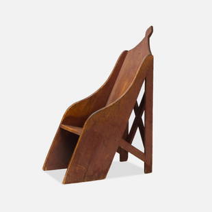
Sold2022American Country, Pitched Scaffolding ChairPennsylvania, 19th Century wood planks, paint, nails 47” x 18” x 32” Unusual Pennsylvania armchair, with scaffold structure supporting the pitched seat and back, finishing in a spadeSee Sold Price
3 days LeftRbfineartsHistorical Map of the State of Kentucky by Karl Smith 1933 Daniel Boone & Companions View$30(2 bids)
3 days LeftTrillium Antique Prints & Rare BooksSanson - Map of Canada or New France with the Great Lakes$75(1 bid)
3 days LeftRbfineartsHistorical Map of the Chesapeake Bay By Edwin Tunis Published By The National Brewing Co.$20(1 bid)
3 days LeftTrillium Antique Prints & Rare BooksSanson - Map of Florida (encompassing most of Southeast North America)$95(2 bids)
6 days LeftTimeLine Auctions Ltd.Renaissance Stained Glass Panel with Two Grotesque Caryatid Herms£65(4 bids)


![[ATLASES].: * [ATLASES]. Four editions of Mitchell's New General Atlas, Containing Maps of the Various Countries of the World, Plans of Cities, Etc. Philadelphia: S. Augustus Mitchell, Jr., 1861 - 1864 - 1878 - 1](https://p1.liveauctioneers.com/197/119933/61100820_1_x.jpg?height=310&quality=70&version=1522758048)