Sold2023AMAZONIA & ANDEAN STATES Colombia Venezuela Ecuador Peru Bolivia Brazil 1907 mapTitle: AMAZONIA & ANDEAN STATES Colombia Venezuela Ecuador Peru Bolivia Brazil 1907 map Description: Colombia, Venezuela, British & Dutch Guiana, Ecuador, Peru, Chile, Bolivia, Paraguay, Argentine RepSee Sold Price
Sold2023Venezuela Colombia Ecuador Amazonia. Northern Andean States. TIMES 1957 mapTitle: Venezuela Colombia Ecuador Amazonia. Northern Andean States. TIMES 1957 map Description: Venezuela // Colombia // Ecuador // Islas Galapagos' by John Bartholomew & son (1957). Vintage colouredSee Sold Price
Sold2024Copacabana Peninsula, Lake Titicaca. Andean States. Bolivia Peru 1885 old mapTITLE/CONTENT OF MAP: 'Copacabana Peninsula' DATE PRINTED: 1885 IMAGE SIZE: Approx 10.5 x 11.0cm, 4.25 x 4.25 inches (Small) TYPE: Antique wood-engraved map; Scale 1:1,000,000 CONDITION: Good; suitablSee Sold Price
Sold2024ANDEAN STATES. Colombia Venezuela Ecuador Peru Bolivia. La Paz plan 1920 mapTITLE/CONTENT OF MAP: 'South America ( Section I ); Inset map of Galapagos ls.; La Paz' DATE PRINTED: 1920 IMAGE SIZE: Approx 34.0 x 45.0cm, 13.25 x 17.5 inches (Large) TYPE: Vintage colour map CONDITSee Sold Price
Sold2023ANDEAN STATES. Colombia Venezuela Ecuador Peru Bolivia. La Paz plan 1920 mapTitle: ANDEAN STATES. Colombia Venezuela Ecuador Peru Bolivia. La Paz plan 1920 map Description: South America ( Section I ); Inset map of Galapagos ls.; La Paz' by Harmsworth (1920). Vintage colour mSee Sold Price
Sold2024Northern South America . Andean states. Brazil. Amazonia. Relief. TIMES 1922 mapTITLE/CONTENT OF MAP: 'South America - northern section' DATE PRINTED: 1922 IMAGE SIZE: Approx 44.5 x 57.5cm, 17.5 x 22.5 inches (Large); Please note that this is a folding map. TYPE: Antique atlas maSee Sold Price
Sold2021Album different bank notes C, Cambodia-CubaThe album contains various banknotes from Cambodia, Cameroon, Canada, Cape Verde, Camen Islands, Central African Republic, Central African States (Chad), Chile, China, Colombia, Comores, Confederate SSee Sold Price
Sold2022LOT OF INTERNATIONAL COINS.This lot consists of over 325 coins from Cambodia, Cameroon, Cape Verde, the Cayman Islands, Central African States, Sri Lanka, Chile, China, Colombia, Cook Island, Costa Rica, Cuba, Curacao and otherSee Sold Price
Sold2017RARE AND IMPORTANT KENTUCKY FOLK ART SCHOOL GIRL MAPS,RARE AND IMPORTANT KENTUCKY FOLK ART SCHOOL GIRL MAPS, LOT OF FIVE, descended in the Cowan and Craig families of Central Kentucky, including "A Map of the United States Drawn by Mary H. L. Craig at thSee Sold Price
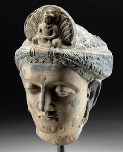
Sold2023Fine 1st C. Gandharan Stone Head Prince Siddhartha**First Time At Auction** Central Asia, Pakistan, India, and Afghanistan, Gandharan Empire, ca. 1st century CE. An incredible schist head wearing a turban-style headdress, in a beautiful state of presSee Sold Price
Sold20227 7/8" 3/4 Grooved Axe Cox COA Ex Buetell, Ex7 7/8" 3/4 Grooved Axe Cox COA Ex Buetell, Ex Steve Lee, Ex Jenkins, Pictured in Who,s Who Vol. 7, and Central States Journal January, 1983, and Legends of Prehistoric Art. Was found in Adams Co, IlliSee Sold Price
Sold2018RARE SPANISH COLONIAL SILVER PELICAN-FORM BOOKSTANDlate 18th/early 19th c., prob. Peru or Alto Peru (Bolivia), a sacramentary lectern the standing bird with out-swept wings, head bent to heart; book rest attached to back, 19"tall incl. the 11&quoSee Sold Price
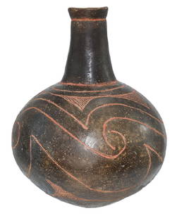
Sold201810" H. Taylor Engraved Bottle. Clark Co, AR.10" H. Taylor Engraved Bottle. Clark Co, AR. Found by Sonny Hutchinson. A Caddo masterpiece, highly polished and finely decorated. Appears solid. Pictured in 2007 #2 Central States (p63), Legends II (See Sold Price
Sold2021Spanish Colonial, Peru, Vargueño Travel Writing ChestSpanish Colonial, Peru, Andes Vargueño Travel Writing Chest, Early 18th Centurya Chinesco-style travel chest, having painted designs with gold leaf estofado work, with original hand-forged hardware,See Sold Price
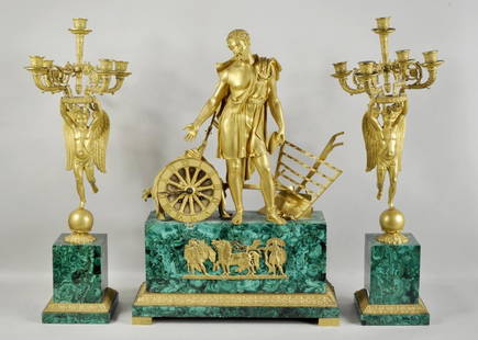
Sold2016Malachite & Bronze Three Piece Clock GarnitureFrench Empire gilt bronze and malachite three piece clock garniture, the central figure depicting time flanked by a pair of angel five-light candelabra. 27 1/4" high, 19" wide to 27 1/2" high, 9" wideSee Sold Price
Sold2024Map of United States of North America, 1785Map of United States of North America, 1785, The Royal Islands of Newfoundland. 26 3/4 x 32 3/4 in framed. 19 x 25 in unframed.Local Pick up call one day before to make an appointment. TO SHIP THIS ITSee Sold Price
Sold2022(REPUBLIC OF TEXAS.) James Hamilton Young. A New Map of Texas, with the Contiguous American &(REPUBLIC OF TEXAS.) James Hamilton Young. A New Map of Texas, with the Contiguous American & Mexican States. Hand-colored engraved map of Texas with inset text panels relating information on its riveSee Sold Price
Sold2024American Hooked CarpetUnited States, Circa 1900 The central oval floral medallion flanked by garlands is on a taupe field. (12' 9" x 11' 9") Areas of wear, restorationsSee Sold Price
Sold2022(CIVIL WAR.) John Bachmann. Panorama of the Seat of War.(CIVIL WAR.) John Bachmann. Panorama of the Seat of War. Portfolio of 6 double-page chromolithographed panoramic perspective maps of Confederate states. Folio, 23½x17 inches, contemporary half moSee Sold Price
Sold2023RARE BUCHOLTZ-LUDWIG ANTEBELLUM POCKET MAP OF VIRGINIARARE BUCHOLTZ-LUDWIG ANTEBELLUM POCKET MAP OF VIRGINIA, hand-colored lithograph, Map of the State of Virginia Containing the Counties, Principal Towns, Railroads, Rivers, Canals & All Other Internal ISee Sold Price
Sold2016America.- Burr (David H.) - An Atlas of the State ofContaining a Map of the State and of the Several Counties, [third edition], engraved title, 51 hand-coloured engraved maps and plans on 52 sheets as issued, including double-page and folding, some foxSee Sold Price
Sold2024FRAMED 19TH C. POCKET MAP OF INDIANAThe Tourist's Pocket Map of the State of Indiana, Exhibiting It's Internal Improvements, Road Distances, etc., by J.H. Young, Philadelphia, Published by S. Augustus Mitchell. 1835. Hand colored engravSee Sold Price
Sold2016A Map of the United States & MexicoHenry Tanner (1786-1858). New York: Tanner, 1850. Hand-colored Pocket Map. 23 x 29 inches visible, 38 x 39 1/2 inches framed.See Sold Price
Featured4 days LeftJasper52Johnson's Venezuela, New Granada, Ecuador, Peru, Bolivia, Chile, Guiana 1861 map$85
4 days LeftJasper52Venezuela, Colombia, Equador & Peru. Andean States Ecuador. BARTHOLOMEW 1898 map$20
Featured4 days LeftJasper52Andean States. Venezuela New Granada Ecuador Peru Colombia. SIDNEY HALL 1854 map$25
4 days LeftJasper52Colombia, Ecuador & Peru. Andean States. Panama canal. 71x52cm STANFORD 1904 map$60
4 days LeftJasper52NW SOUTH AMERICA. Colombia Venezuela Ecuador Peru Bolivia Brazil. Lima 1907 map$10
4 days LeftJasper52Northern South America . Andean states. Brazil. Amazonia. Relief. TIMES 1922 map$10
Featured4 days LeftJasper52SOUTH AMERICA. Brazil Chile Peru Bolivia Patagonia La Plata. SDUK 1844 old map$100
4 days LeftJasper52SOUTH AMERICA. With United States of Colombia(Colombia & Panama).BUTLER 1888 map$8
4 days LeftJasper52PERU & BOLIVIA. Bolivia with Atacama litoral.Potosi view TALLIS/RAPKIN 1851 map$100
4 days LeftJasper52PERU & BOLIVIA. Bolivia with Atacama litoral.Potosi view RAPKIN/TALLIS 1851 map$100


![America.- Burr (David H.) - An Atlas of the State of: Containing a Map of the State and of the Several Counties, [third edition], engraved title, 51 hand-coloured engraved maps and plans on 52 sheets as issued, including double-page and folding, some fox](https://p1.liveauctioneers.com/410/84263/43496522_1_x.jpg?height=310&quality=70&version=1453293226)


