Sold20231759 Tirion Map of the Americas -- Nieuwe Kaart van America…Title: 1759 Tirion Map of the Americas -- Nieuwe Kaart van America… Cartographer: I Tirion Year / Place: 1759 c., Amsterdam Map Dimension (in.): 10.8 X 12.5 in. This is wonderful map of the AmerSee Sold Price
Sold20231755 Tirion Map of Eastern North America -- Nieuwe Kaart van de Grootbrittannische Volkplantingen inTitle: 1755 Tirion Map of Eastern North America -- Nieuwe Kaart van de Grootbrittannische Volkplantingen in Noord America Cartographer: I Tirion Year / Place: 1755, Amsterdam Map Dimension (in.): 14.3See Sold Price
Sold2019Isaak Tirion (1705-1765, Amsterdam), "Nieuwe Kaart vanIsaak Tirion (1705-1765, Amsterdam), "Nieuwe Kaart van America," 1766, hand colored, H. - 12 in., W. - 13 in.See Sold Price
Sold2016Map, Isaak Tirion, Nieuwe Kaart Van EuropaIsaak Tirion (Dutch, 1705-1765), "Nieuwe Kaart Van Europa," hand-colored copper engraving, overall (with frame): 19"h x 21"wSee Sold Price
Sold2019Map of England & Wales 1760Heading: (Maps) Author: Tirion, Isaac Title: Nieuwe Kaart van 't Zuider Gedeelte van Groot Britannie behelzende Het Koningryk Engeland… Place Published: Amsterdam Publisher: Date Published: 1See Sold Price
Sold2017Moll / Oldmixon: Antique Map of North America, 1721Map: Nieuwe Kaart van Noord Amerika Cartographer: H. Moll / Oldmixon Place & Date: Amsterdam / 1721 Size: 9 3/4" x 6 3/4" Condition: outline color; overall age toning and minor spotting In this DutchSee Sold Price
Sold2017Tirion: Antique Map of the Western Hemisphere, 1754Map: Nieuwe Kaart van het Westelykste Deel der Wereeld Cartographer: Isaac Tirion Place & Date: Amsterdam / 1754 Size: 14 1/4" x 13 1/4" Condition: wash color; light overall age toning; backed to reinSee Sold Price
Sold2021Tirion 1733 Map of AsiaDESCRIPTION: Map by Isaac Tirion, engraved by Jacob Keyser. Titled "Nieuwe Kaart van Asia na de alderlaatste Ontdekking int licht gebracht." Depicts Japan, Kamchatka Peninsula, Australia's northern coSee Sold Price
Sold2023MAP, Malta, TirionMalta. Isaac Tirion, Nieuwe Kaart van't Eiland Maltha met Gozo en Comino..., from Nieuwe en Beknopte Hand Atlas, 1761 (dated). Hand Color. Handsome, large map of the Maltese Islands with superb detailSee Sold Price
Sold2017An antique map of Poland by Izaak Tirion, circa 1740An antique map of Poland by Izaak Tirion, circa 1740 Title: [Old Antique map of Poland / Lithuania] Nieuwe Kaart van het Koninkryk Poolen. Author: Tirion, Izaak , Amsterdam, c. 1740. DescriSee Sold Price
Sold2017MAP, C. 1750, INDIA & SOUTHEAST ASIA, ISAAK TIRIONFramed map of India an nearby countries, "Nieuwe Kaart van India over de Ganges of van Malakka, Siam, Cambodia, Chiampa, Kochinchina, Laos, Pegu, Ava" c. 1750 by Issak Tirion (Dutch, 1705-1765), handSee Sold Price
Sold2019India.- Tirion (Isaac) Nieuwe Kaart van t Keyzer RykIndia.- Tirion (Isaac) Nieuwe Kaart van t Keyzer Ryk van den Grooten Mogol, map of The Mughal Empire, which included India, Sri Lanka, Pakistan and Bangladesh, engraved map with hand-colouring on laidSee Sold Price
Sold202418TH CENTURY MAP OF CANADABy Isaak Tirion, dated 1769, “Nieuwe Kaart van Kanada…Hudsons Baay…Noord Amerika”, hand- coloured, measuring 13 ½” x 18”.See Sold Price
Sold20221687 Keulen Map of North and South America's Mostly Atlantic Coastal Areas -- Pas Kaart van WestTitle: 1687 Keulen Map of North and South America's Mostly Atlantic Coastal Areas -- Pas Kaart van West Indien Behelsende soo Deszelffs Vaste Kusten als d'Onder Behoorende Eylanden aan de Noord OceaanSee Sold Price
Sold2024MAP, Panama, TirionPanama. Isaac Tirion, Kaart van de Landengte van Panama, Volgens de Spaansche Aftekeninge Opgemaakt, from Nieuwe en Beknopte Hand-Atlas, 1766 (circa). Hand Color. Great map of central Panama showing PSee Sold Price
Sold2019Isaak Tirion (1705-1765, Amsterdam), "Nieuwe Kaart vanIsaak Tirion (1705-1765, Amsterdam), "Nieuwe Kaart van Arabia,"18th c., hand colored, H. - 15 in., W. - 18 in.See Sold Price
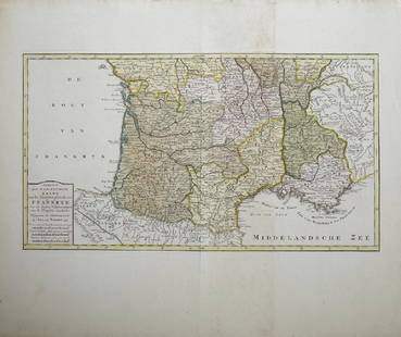
Sold2019Isaak Tirion (1705-1765, Amsterdam), "Nieuwe Kaart vanIsaak Tirion (1705-1765, Amsterdam), "Nieuwe Kaart van het Zuidelykste Gedeltevan Frankryk," 1757, hand colored, H. - 16 7/8 in., W. - 20 7/8 in.See Sold Price
Sold2019Isaak Tirion (1705-1765, Amsterdam), "Nieuwe Kaart vanIsaak Tirion (1705-1765, Amsterdam), "Nieuwe Kaart van Frankryk," hand colored, H. - 17 in., W. -20 1/2 in.See Sold Price
Sold2019Emanuel Bowen (1693-1767, "Nieuwe en Algemeene KaartEmanuel Bowen (1693-1767, "Nieuwe en Algemeene Kaart van America, Getrokken mil. Landkarten," 1783, hand colored, H.- 18 1/2 in., W.- 23 in.See Sold Price
Sold2018van Keulen: Antique Map Guadeloupe & Marie Galante 1720Title/Content of Map: Nieuwe Land en Zee Kaart van de Eylanden Guadalupe en Mariegalande Cartographer: van Keulen Place & Date: Amsterdam / 1720/1780 Size: 22 1/2" x 19 7/8" Condition: b&w; overall agSee Sold Price
Sold2024Military Costume Print LotVarious antique and vintage prints, including French military dress. Also battle scene views, Nieuwe Kaart map by Isaac Tirion, etc. Condition varies.See Sold Price
Sold2022Map of Suriname – 18th Century – With Notation ofNieuwe Kaart van Suriname vertonende de stromen en land-streken van Suriname, Comowini, Cottica, en Marawini. Map of Suriname, hand-colored. Amsterdam: J. Ottens, [early 18th century].A detailed map oSee Sold Price
Sold2017Tirion: Antique Map of Isthmus of Panama, 1750Map: Kaart van de Landengte van Panama (Isthmus of Panama) Cartographer: Tirion Place & Date: Amsterdam / 1750 Size: 11 7/8" x 10 5/8" Condition: wash color; light overall age toning A beautifully desSee Sold Price
Sold2017Tirion: Antique Map of Panama, 1750Map: Kaart van de Landengte van Panama Cartographer: Tirion Place & Date: Amsterdam / 1750 Size: 11 7/8" x 10 5/8" Condition: b&w; overall age toning and minor spotting A beautifully designed and highSee Sold Price
3 days LeftBADO e MART AUCTIONSAMERICA. MONTANUS. De nieuwe en onbekende Weereld: of Beschryving van America en't Zuid-Land.€8,500
5 days LeftTrillium Antique Prints & Rare BooksVan der Aa - Map of Central America: Yucatan Peninsula (Explorer: Gil Gonzalez Davila)$75
3 days LeftLeland LittleRobert de Vaugondy's 18th-Century French Map of North America's Eastern Seaboard$50
5 days LeftTrillium Antique Prints & Rare BooksVan der Aa - Map of Southern Atlantic Ocean: South America, part of North America, Europe, Africa$75
5 days LeftTrillium Antique Prints & Rare BooksDe L'Isle - Map of Louisiana and the Course of the Mississippi (Eastern America) (First Appearance$240(2 bids)
3 days LeftJasper52United States of America. California Gold region. THOMAS, COWPERTHWAIT 1852 map$380
2 days LeftAugusta AuctionsMONIQUE VAN VOOREN WORN CHADO RALPH RUCCI EVENING GOWN, AMERICA, MODERN$250(1 bid)
5 days LeftBrunk AuctionsJohn Mitchell - A Map of the British and French Dominions in North America, 1755-1757$24,000
3 days LeftJasper52United States of North America, Pacific States by Joseph Wilson Lowry 1860 map$340


![An antique map of Poland by Izaak Tirion, circa 1740: An antique map of Poland by Izaak Tirion, circa 1740 Title: [Old Antique map of Poland / Lithuania] Nieuwe Kaart van het Koninkryk Poolen. Author: Tirion, Izaak , Amsterdam, c. 1740. Descri](https://p1.liveauctioneers.com/6018/113868/58519818_1_x.jpg?height=310&quality=70&version=1513369839)


![Map of Suriname – 18th Century – With Notation of: Nieuwe Kaart van Suriname vertonende de stromen en land-streken van Suriname, Comowini, Cottica, en Marawini. Map of Suriname, hand-colored. Amsterdam: J. Ottens, [early 18th century].A detailed map o](https://p1.liveauctioneers.com/3506/232707/120467405_1_x.jpg?height=310&quality=70&version=1641394058)


![[MAPS] MISC CANADA/AMERICA. LOT OF 6 (1 of 6)](https://p1.liveauctioneers.com/8124/343618/186530170_1_x.jpg?height=282&quality=70&version=1726178725)


![[MAPPING] LOT OF 3 VOLUMES SOLD TOGETHER (1 of 3)](https://p1.liveauctioneers.com/8124/343618/186530159_1_x.jpg?height=282&quality=70&version=1726178725)


![[MAPS] DOUBLE-PAGE. LOT OF 4 SOLD TOGETHER (1 of 4)](https://p1.liveauctioneers.com/8124/343618/186530168_1_x.jpg?height=282&quality=70&version=1726178725)
![[AMERICA] PHILADELPHIA. LOT OF 4 VOLUMES TOGETHER (1 of 4)](https://p1.liveauctioneers.com/8124/343618/186530073_1_x.jpg?height=282&quality=70&version=1726178725)


