Sold2023AMAZONIA & ANDEAN STATES Colombia Venezuela Ecuador Peru Bolivia Brazil 1907 mapTitle: AMAZONIA & ANDEAN STATES Colombia Venezuela Ecuador Peru Bolivia Brazil 1907 map Description: Colombia, Venezuela, British & Dutch Guiana, Ecuador, Peru, Chile, Bolivia, Paraguay, Argentine RepSee Sold Price
Sold2023Venezuela Colombia Ecuador Amazonia. Northern Andean States. TIMES 1957 mapTitle: Venezuela Colombia Ecuador Amazonia. Northern Andean States. TIMES 1957 map Description: Venezuela // Colombia // Ecuador // Islas Galapagos' by John Bartholomew & son (1957). Vintage colouredSee Sold Price
Sold2024Copacabana Peninsula, Lake Titicaca. Andean States. Bolivia Peru 1885 old mapTITLE/CONTENT OF MAP: 'Copacabana Peninsula' DATE PRINTED: 1885 IMAGE SIZE: Approx 10.5 x 11.0cm, 4.25 x 4.25 inches (Small) TYPE: Antique wood-engraved map; Scale 1:1,000,000 CONDITION: Good; suitablSee Sold Price
Sold2024ANDEAN STATES. Colombia Venezuela Ecuador Peru Bolivia. La Paz plan 1920 mapTITLE/CONTENT OF MAP: 'South America ( Section I ); Inset map of Galapagos ls.; La Paz' DATE PRINTED: 1920 IMAGE SIZE: Approx 34.0 x 45.0cm, 13.25 x 17.5 inches (Large) TYPE: Vintage colour map CONDITSee Sold Price
Sold2023ANDEAN STATES. Colombia Venezuela Ecuador Peru Bolivia. La Paz plan 1920 mapTitle: ANDEAN STATES. Colombia Venezuela Ecuador Peru Bolivia. La Paz plan 1920 map Description: South America ( Section I ); Inset map of Galapagos ls.; La Paz' by Harmsworth (1920). Vintage colour mSee Sold Price
Sold2024Northern South America . Andean states. Brazil. Amazonia. Relief. TIMES 1922 mapTITLE/CONTENT OF MAP: 'South America - northern section' DATE PRINTED: 1922 IMAGE SIZE: Approx 44.5 x 57.5cm, 17.5 x 22.5 inches (Large); Please note that this is a folding map. TYPE: Antique atlas maSee Sold Price
Sold20213 1/16" Dovetail ArrowheadFound In Cass County or Brown County Illinois. Ex: Lloyd Miller Collection. Pictured in Central States Archaeological Journal 1957 and In The Beardstown Book by Harold Tyson.See Sold Price
Sold2024(3) Texas History DocumentsThree pieces of Texas ephemera, includes map of West central states, and states of the plains, including Texas, Arkansas, and Louisiana, one map of Texas with informational text stating it originallySee Sold Price
Sold2021Album different bank notes C, Cambodia-CubaThe album contains various banknotes from Cambodia, Cameroon, Canada, Cape Verde, Camen Islands, Central African Republic, Central African States (Chad), Chile, China, Colombia, Comores, Confederate SSee Sold Price
Sold2022LOT OF INTERNATIONAL COINS.This lot consists of over 325 coins from Cambodia, Cameroon, Cape Verde, the Cayman Islands, Central African States, Sri Lanka, Chile, China, Colombia, Cook Island, Costa Rica, Cuba, Curacao and otherSee Sold Price
Sold2017RARE AND IMPORTANT KENTUCKY FOLK ART SCHOOL GIRL MAPS,RARE AND IMPORTANT KENTUCKY FOLK ART SCHOOL GIRL MAPS, LOT OF FIVE, descended in the Cowan and Craig families of Central Kentucky, including "A Map of the United States Drawn by Mary H. L. Craig at thSee Sold Price
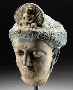
Sold2023Fine 1st C. Gandharan Stone Head Prince Siddhartha**First Time At Auction** Central Asia, Pakistan, India, and Afghanistan, Gandharan Empire, ca. 1st century CE. An incredible schist head wearing a turban-style headdress, in a beautiful state of presSee Sold Price
Sold2024United States Map 1783 [178199]Published in 1986 for the Exhibition at the National Archives in celebration of the 200th anniversary of the Constitution. A reproduction of a 1783 map of the United States of America by John Wallis oSee Sold Price
Sold20227 7/8" 3/4 Grooved Axe Cox COA Ex Buetell, Ex7 7/8" 3/4 Grooved Axe Cox COA Ex Buetell, Ex Steve Lee, Ex Jenkins, Pictured in Who,s Who Vol. 7, and Central States Journal January, 1983, and Legends of Prehistoric Art. Was found in Adams Co, IlliSee Sold Price
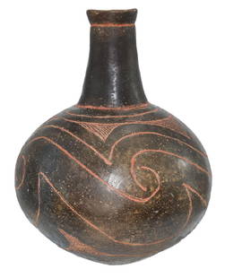
Sold2018RARE SPANISH COLONIAL SILVER PELICAN-FORM BOOKSTANDlate 18th/early 19th c., prob. Peru or Alto Peru (Bolivia), a sacramentary lectern the standing bird with out-swept wings, head bent to heart; book rest attached to back, 19"tall incl. the 11&quoSee Sold Price
Sold201810" H. Taylor Engraved Bottle. Clark Co, AR.10" H. Taylor Engraved Bottle. Clark Co, AR. Found by Sonny Hutchinson. A Caddo masterpiece, highly polished and finely decorated. Appears solid. Pictured in 2007 #2 Central States (p63), Legends II (See Sold Price
Sold2021Spanish Colonial, Peru, Vargueño Travel Writing ChestSpanish Colonial, Peru, Andes Vargueño Travel Writing Chest, Early 18th Centurya Chinesco-style travel chest, having painted designs with gold leaf estofado work, with original hand-forged hardware,See Sold Price
Sold2024Book titled "Guide for Emigrants, Containing Sketches of Illinois, Missouri, and the Adjacent Parts"Book titled "Guide for Emigrants, Containing Sketches of Illinois, Missouri, and the Adjacent Parts" by J.M. Peck, published in Boston 1831. With original pull-out map of the Western States. The map wSee Sold Price
Sold2024AUTOMOTIVE ACCESSORIESMobil Lubrication Customer Record Box, porcelain, 9 1/2" x 8 1/2" x 6 1/2", w/maps & time tables, Shell Thermometer, 17", working, Shell Oil Can, 8 1/2", Texaco Map Holder, 4" x 4" x 2 1/2", porcelainSee Sold Price
Sold2024United States: Eastern Portion. Map identifying slave slates.Johnston, Alexander. Edinburgh, Scotland: A. K. Johnston, Ca. 1858 - 1862. Scarce pre-Civil War map of the United States, by the renowned Scottish cartographer and geographer, Alexander Johnston. WorlSee Sold Price
Sold2024MAP, United States, SolteszUnited States. Frank Soltesz, Folklore and Legends of Our Country, 1960 (dated). Printed Color. This large pictorial map was drawn by Frank Soltesz and published by the Humble Oil & Refining Company.See Sold Price
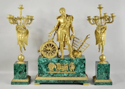
Sold2016Malachite & Bronze Three Piece Clock GarnitureFrench Empire gilt bronze and malachite three piece clock garniture, the central figure depicting time flanked by a pair of angel five-light candelabra. 27 1/4" high, 19" wide to 27 1/2" high, 9" wideSee Sold Price
Sold2024Map of United States of North America, 1785Map of United States of North America, 1785, The Royal Islands of Newfoundland. 26 3/4 x 32 3/4 in framed. 19 x 25 in unframed.Local Pick up call one day before to make an appointment. TO SHIP THIS ITSee Sold Price
Sold2024A PREFECTURAL MAP OF IMPERIAL STATE JINFU.Prefectural Map of Imperial State Jinfu, on Paper.See Sold Price
Oct 05North American Artifact AuctionsPre-Columbian Stone Toucan found in Central America - Peru$12(2 bids)
Oct 27Schilb Antiquarian Rare Books1861 SLAVE States Journey in Seaboard American SLAVERY Economics Olmsted$90(3 bids)
Oct 12JM Hobby Supply and Railroad Artifact AuctionsChesapeake and Delaware Canal Company Fifth Annual Report-1824$50(1 bid)
3 days LeftFrost & NicklausMaud Purdy, Impressionist Landscape Oil Painting, Signed 1957, Framed$3,950
5 days LeftBrunk AuctionsExceptionally Rare Price-Strother Survey of North Carolina Map, c. 1808$60,000
Oct 12JM Hobby Supply and Railroad Artifact AuctionsNew York Central RR RUTLAND Station Cast Iron Approach Sign $200
5 days LeftBrunk AuctionsJohn Mitchell - A Map of the British and French Dominions in North America, 1755-1757$24,000


![United States Map 1783 [178199]: Published in 1986 for the Exhibition at the National Archives in celebration of the 200th anniversary of the Constitution. A reproduction of a 1783 map of the United States of America by John Wallis o](https://p1.liveauctioneers.com/2699/343231/186247640_1_x.jpg?height=310&quality=70&version=1725927388)