Sold2024Six Maps including Visscher's Map of America[SIX MAPS] 1. VISSCHER, Nicolas (1618-1679). Novissima et Accuratissima Totius Americae descriptio. Engraved map with original hand color. Amsterdam, c. 1677. 20" x 24" visible, 29 1/2" x 33 1/2" framSee Sold Price
Sold2016Six British and American Historical EngravingsGroup of Six British and American Historical Engravings, 19th century, including "Map of The United States of America and Nova Scotia", engraved by Fenner, Sears and Company, published by T. Hinton anSee Sold Price
Sold2023Six maps of various regions of the United States, from municipal to multiple states in scale,Six maps of various regions of the United States, from municipal to multiple states in scale, including: "A Chorographical Map of the Province of New York in North America", Pease, 1849, 40" h. x 32"See Sold Price
Sold2020Group of Maps of RussiaGroup of six maps of Russia, including regional maps of Georgia and Siberia. Many abundantly illustrated. Dimensions: Largest map; height: 21 in x width: 24 in. SKU: 03630See Sold Price
Sold2020Antique Maps by Augustus Mitchell (8)Various maps, including North America, South America, Europe, Italy, Spain, Greece, Brazil. Hand-colored engravings. S. Augustus Mitchell, Philadelphia, c. 1850. 17 1/2" x 14 1/4".See Sold Price
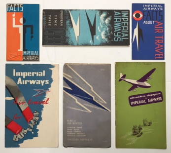
Sold2017Imperial Airways, six publicity booklets including MapImperial Airways, six publicity booklets including Map of European Air Routes, folding page artwork by Edward Bawden, 1933; European Timetable with cover design by Kauffer, 1933; Facts about Air TraveSee Sold Price
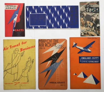
Sold2017Imperial Airways, six publicity booklets including MapImperial Airways, six publicity booklets including Map of the Air Route Cairo-Capetown, folding page artwork by Edward Bawden, coiver by Lee-Elliott 1934-5; European Timetable with cover design by LeeSee Sold Price
Sold2020[CARRIBEAN AND SOUTH AMERICA]. 6 mapsCaribbean and South America. Lot of 6 maps, including: Kitchin, Thomas. The Gulf of Mexico. Islands andCountries adjacent. For the Rev. Dr. Robertson's History of America. London: T. Cadell; J. CrofsSee Sold Price
Sold2017Two hand colored engraved double page large folio mapsTwo hand colored engraved double page large folio maps including The United States of America and Map of New York and the Adjacent Cities. 16 1/2" x 27" and 17 1/2" x 27" Provenance: Property from CSee Sold Price
Sold2020Grp: 6 Maps of AsiaGroup of six maps of Asia and the Near East, including maps of the Persian Empire, Eastern and South Eastern Asia, Asia Minor, and Asia. SKU: 03488See Sold Price
Sold2021Collection of Antique Maps of North AmericaA framed collection of nine small maps including "The English Empire in America, Newfound-Land, Canada, Hudsons Bay &c. in Plano" by Herman Moll circa 1709 and "North America from the Best AuthoritiesSee Sold Price
Sold2022[GREAT LAKES REGION]. A pair of engraved maps, including: T...[GREAT LAKES REGION]. A pair of engraved maps, including: TANNER, Henry Schenk. North America: Sheet V The Northwest and Michigan Territories. London Baldwin & Cradock, 1833. Hand–outlined in coSee Sold Price
Sold2018Earnest Dudley Chase, "America the Wonderland" MapEarnest Dudley Chase (1878-1966) America the Wonderland map - 1941, including dozens of vignettes of buildings around the US Signed on lower left "E. Dudley Chase" Approx. 21" x 27.5"See Sold Price
Sold2020Grp: 6 Maps of Europe by Braun & HogenbergGroup of six maps by Georg Braun (1541–1622) and Frans Hogenberg (1540–1590) including maps of Ghent, Odense in Denmark originally for the book "Civitates Orbis Terrarum", a map of ParisSee Sold Price
Sold2022ANTIQUE CENTRAL AMERICA MAPS AND ENGRAVINGA collection of antique Central America region maps and engravings including a 1778 large detailed map of the Island of Dominica, a 1794 map of the island of Saint Vincent showing its late eighteenthSee Sold Price
Sold2023COLLECTION VINTAGE PENNANTS / MAPSCollection of pennants and maps including; 1964-5 World's Fair, Six Flags-Georgia, Mt. Vernon, Staten Island Zoo, Hershey Pa, Niagara Falls, West Point, etcSee Sold Price
Sold2022Three Maps of North America, One World MapFour maps, including: Robert Wilkinson, The United States of America Confirmed By Treaty 1783, London, circa 1800-1812, engraving on wove paper; L'Amerique Septentrionale, "Terres vues par Tchirikov 1See Sold Price
Sold2021HOMANN, ENGLISH TERRITORIES IN NORTH AMERICA, MAPJohann Baptist Homann (German, 1664-1724). "Dominia Anglorum in America Septentrionali" - circa 1740, engraving with hand coloring. Note: Map depicts four separate maps including plans of Virginia, MaSee Sold Price
Sold201819C Oak Map Print Paper Collector's Case CabinetUnited States,Late 19th Century Six long drawers with bin pulls on a molded base, used for holding works on paper including maps and blueprints. Oak 57" x 36" x 32", From an Exeter, Rhode Island estatSee Sold Price
Sold2023Five Antique Maps, North & South AmericaDescription: Five antique maps including a 1834 Charles Bowen mapof the Great American Eclipse, an unattributed 1825 map of New England, an 1834 Graf & Sorel map of Nunavut, Canada from the exploratioSee Sold Price
Sold2023SOCIETY FOR DIFFUSION OF USEFUL KNOWLEDGE, A REPUBLIC OF TEXAS MAP, "Central America II. IncludingSOCIETY FOR DIFFUSION OF USEFUL KNOWLEDGE, A REPUBLIC OF TEXAS MAP, "Central America II. Including Texas, California and the Northern States of Mexico," LONDON, CIRCA 1842, lithograph on paper, publisSee Sold Price
Sold2022Six Atlas of New York and Vicinity, hand colored engraved maps including Sommers, Patterson,Six Atlas of New York and Vicinity, hand colored engraved maps including Sommers, Patterson, Wakefield, Ossining, City Island, and North Salem, 16 3/4" x 13 3/4". Provenance: Originally from Credit SuSee Sold Price
Sold2020Six early Boston AlmanacsGrouping of 6 Boston Almanacs including 1859, 1860, 1861, 1876, 1885, and 1887. The 1859 and 1860 with damage to spines, otherwise all are complete (including maps and many advertising pages) and in gSee Sold Price
Sold2015Map LotLot of (4) maps including "Das Herzogthum Schlesien" (sight 10" x 14 1/2"), "North America" (sight 14" x 10 1/2"), "Columbia Co." (19 1/2" x 15 1/2"), "Hillsdale Quadrangle"(sight 26 1/2" x 15").See Sold Price
May 30NY Elizabeth ANTIQUE MAP-ILLUSTRATED FLORAL ILLUSTRATION 1761 NEW DICTIONARY OF TRADE AND COMMERCE R. ROTH$50
May 29Jasper52Partie méridionale Du Bresil… River Plate basin Brazil Uruguay. BONNE 1780 map$25
Jun 08Early American History Auctions1853 Map of Portion of British North America and Gulf of St. Lawrence, by Henry Perley$260
May 29Jasper52Carte du Nouveau Royaume de Grenade… Colombia Venezuela Guyana. BONNE 1780 map$35
21 hrs LeftForum AuctionsRussia.- Peter the Great.- Uystryalov (Nikolai) Karty, Plany I Snimki K Pervym Trem Tomam£750
May 30Forum AuctionsAmerica.- California gold mining.- Palmer (N.S.) Autograph Letter signed to his brother on mining£400
Jun 02Schilb Antiquarian Rare Books1897 History of British Empire England Scotland Canada James II MAPS India 6v$3(2 bids)
May 29Jasper52La partie méridionale du Brésil et du Perou. SANTINI/D'ANVILLE 1784 old map$80
Jun 07Freeman's | HindmanCUNARD, Nancy, editor. Negro Anthology. 1934. FIRST EDITION. ASSOCIATION COPY WITH NOEL SULLIVAN$2,000
May 29Jasper52SOUTH AMERICA. La Plata & Chilé. Chile Argentina Uruguay Bolivia. SDUK 1851 map$40
Jun 07Freeman's | HindmanGODMAN, Frederick DuCane and Osbert SALVIN, editors. -- MAUDSLEY, A. P. Biologia$1,000


![Six Maps including Visscher's Map of America: [SIX MAPS] 1. VISSCHER, Nicolas (1618-1679). Novissima et Accuratissima Totius Americae descriptio. Engraved map with original hand color. Amsterdam, c. 1677. 20" x 24" visible, 29 1/2" x 33 1/2" fram](https://p1.liveauctioneers.com/1968/314554/168606424_1_x.jpg?height=310&quality=70&version=1704142666)


![[CARRIBEAN AND SOUTH AMERICA]. 6 maps: Caribbean and South America. Lot of 6 maps, including: Kitchin, Thomas. The Gulf of Mexico. Islands andCountries adjacent. For the Rev. Dr. Robertson's History of America. London: T. Cadell; J. Crofs](https://p1.liveauctioneers.com/1124/187577/94368856_1_x.jpg?height=310&quality=70&version=1607095126)


![[GREAT LAKES REGION]. A pair of engraved maps, including: T...: [GREAT LAKES REGION]. A pair of engraved maps, including: TANNER, Henry Schenk. North America: Sheet V The Northwest and Michigan Territories. London Baldwin & Cradock, 1833. Hand–outlined in co](https://p1.liveauctioneers.com/928/252933/131521733_1_x.jpg?height=310&quality=70&version=1656110480)


