Sold2024TWO NAUTICAL CHARTSEast Coast of North America 1870, 47 inches by 33 inches. George W. Eldridge Chart of Kennebec River to Deer Isle, 1916, 35 inches by 59 inches. Together with blue print of the US Merrimack and an 183See Sold Price
Sold20221899 Pharmary Board Certificate & Two Nautical ChartsQuantity: 3 Condition: Fair to Good Materials: Paper Item location: NSW, Australia Shipping: In-house shipping available (+5%) see PSee Sold Price
Sold2023Early German Dividing Caliper, 16th CenturyEarly German Dividing Caliper, 16th Century Compass with 2 points, wrought iron, length 11 in. - Used to mark out locations or on nautical chart to measure a distance between two points on a map. Fr&#See Sold Price
Sold2020TWO FRAMED ENGLISH NAUTICAL MAPScomprising 'Harwich Harbor' and 'Great Circle Sailing Chart of the North Atlantic Ocean' Harwich Harbor: 27 x 52 inches sight; the other, 32 1/4 x 38 1/2 inches sightSee Sold Price
Sold2019Nautical Treaty - United States & Britain 1816Notes on the Practical Effect of the Treaty Lately Made Between Great Britain and the United States Attached are two fold-out charts of American VesselsSee Sold Price
Sold2021Eight Framed New England Nautical Charts.Largest frame 49 x 36 inches. This item is not eligible for in house shipping. Buyer will be responsible for arranging pickup or delivery.See Sold Price
Sold2017Antique Nautical Chart of West Mediterranean SeaMap: Old nautical chart of the west Mediterranean Sea Subtitle: Mediterranean Sea, Gibraltar to Alicante, Cape Spartel to Cape Ferrat from Spanish and French Government Charts to 1877. Creator: BritisSee Sold Price
Sold2018Lot of Two Nautical InstrumentsAn assembled pairing of two nautical instruments to include a J.H. Weil & Co., Philadelphia convertible level and a John E. Hand & Sons compass in fitted wood case. Level: 7-1/8 in tall x 12 in wide.See Sold Price
Sold2024Two Nautical PaintingsTwo Nautical Paintings to include Boats on the coast Oil on canvas Signed lower right Flores 15" x 23" Charles Broome (19th/20th century) Sailing ship Oil on board Signed lower left Chas. Broome 22" xSee Sold Price
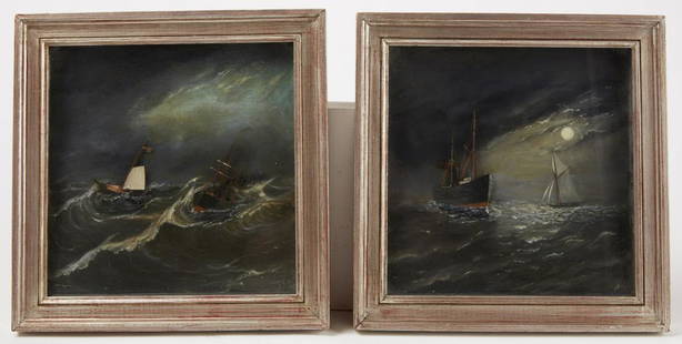
Sold2020Two Nautical PaintingsTwo unusual folk art nautical paintings with boats in relief. Oil and mixed media . American, early 20th century. Framed size 12" x 12". Please refer to this link for high-res images. https://www.dropSee Sold Price
Sold2019Harry Bouras (American, 1931-1990) Two Charts from aHarry Bouras (American, 1931-1990) Two Charts from a Possible Future. Pair of lithographs, each pencil signed lower right, dated 1974, titled, numbered 1/75, and bearing the artist's stamp Each: 13" xSee Sold Price
Sold2023Two Nautical Instruments and a Clockthe first: a Swiss glass and brass ball clock, signed "Swiss Made" to dial (3 3/4 in., Case: 2 5/8 x 5 x 4 1/8 in.); the second: a T. Cooke, London nautical compass (5 x 3 1/4 x 1 5/8 in., Case: 2 5/8See Sold Price
Sold2024Two nautical insturmentsTwo nautical insturments, 19th/early 20th century, comprising brass anchor form tiller yoke and a depth recorder, 25”l. Provenance: Estate of Meri Jaye, a renowned maritime collector and interioSee Sold Price
Sold2023TWO NAUTICAL THEME BOAT PENNY TOYS1208. TWO NAUTICAL THEME BOAT PENNY TOYS | Germany. | 4" l. | (Excellent Condition) | $200 - $400See Sold Price
Sold2021Two Nautical Themed PaintingsOne Giclee Of Ships, 20 C, 32.25w X 23.25h, A Portrait Of An Officer, Is An Antique Oil Painting, 29.75w X 35h.See Sold Price
Sold2023Two nautical sextants. Including: Sextant. London: Stanley, [ca. 19th century]. Copper with brassTwo nautical sextants. Including: Sextant. London: Stanley, [ca. 19th century]. Copper with brass furniture, original glass and mirrors (one mirror is chipped and broken, some tarnishing to gauge, ligSee Sold Price
Sold2020TWO NAUTICAL THEMED STILL BANKS.American, 20th century. Cast iron construction. Steam side-wheel boat, 3"h., and a reproduction military ship named "Oregon", 5.5"h.See Sold Price
Sold2022Two charts of the vicissitudes of human lifeTwo charts of the vicissitudes of human life, and nature19th centuryHand drawn whimsical charts of the human condition; with explanatory notes and landscapes pertaining to the various paths of human lSee Sold Price
Sold2024Two nautical paintings, seascape & moored sailboats oil on canvas, seascape, small sail boat inTwo nautical paintings, seascape & moored sailboats oil on canvas, seascape, small sail boat in large wavy seas is signed June Nelson, 17.5" by 36" & Bay scene with sailboats, figures, signed Antony,See Sold Price
Sold2021Two Nautical Etchings.One by George C. Wales (1867-1941), 10 x 6 inches, sight, pencil signed and titled. One by Norman Wilkinson, 9.25 x 12.75 inches, sight, pencil signed with label for Arthur H. Harlow & Co.See Sold Price
Sold2023Two Nautical Themed Decorative ItemsTwo Nautical Themed Decorative Items, 20th Century, Comprising of a Georgian style wood and brass octant. Together with a Perko wood and brass running light for boats. Light dimensions: L: 52 x W: 6 iSee Sold Price
Sold2021LOT OF TWO NAUTICAL INSTRUMENTSTwo nautical instruments. One bearing circle and a range finder. Weight is 7 pounds.See Sold Price
Sold2022Set of Two Nautical Framed PrintsTwo beautiful realism setting of 1880s British Royal Navy warships. 'First Rate Ships of the Line Off the Needles 1858' by H. W. Affrey, and 'The Barque "Ocean Pride" 1865' By John Scott. Wood, metal,See Sold Price
Sold2021Two nautical sextantsTwo nautical sextants Largest sextant: 7" Length (box is 7.5" x 7.5" x 4.5")See Sold Price
2 days LeftJasper52Bahamas. San Salvador Crooked Rum Cay Mariguana ADMIRALTY chart 1892 (1919) map$140
2 days LeftJasper52Bahamas harbours Pelican Abaco Berry I Jumentos ADMIRALTY chart 1899 (1920) map$140
Featured2 days LeftJasper52Dominica, British West Indies. Caribbean. US Navy sea chart 1892 (1917) map$140
2 days LeftJasper52Anguilla St. Martin/Maarten Barts. Caribbean. US Navy sea chart 1899 (1917) map$280
2 days LeftJasper52Jamaica SE coast Morant-Portland Pt Kingston ADMIRALTY sea chart 1963 (1971) map$120
2 days LeftJasper52West India Islands & Caribbean Sea Sheet 2 ADMIRALTY sea chart 1913 (1949) map$120
2 days LeftJasper52Barbuda Island. West Indies Caribbean. ADMIRALTY sea chart 1850 (1966) old map$120
2 days LeftJasper52Kingston approach Jamaica south coast Caribbean ADMIRALTY chart 1962 (1966) map$120
2 days LeftJasper52Venezuela Coast Trinidad Tobago Isla Margarita ADMIRALTY chart 1894 (1950) map$120
2 days LeftJasper52Jamaica & the Pedro Bank. South Cuba Haiti. ADMIRALTY sea chart 1866 (1968) map$120
2 days LeftJasper52Grand Bahama & Great Abaco Islands. Bahamas. ADMIRALTY sea chart 1886 (1968) map$140
Featured2 days LeftJasper52Kingston Harbour Port Royal Jamaica Caribbean ADMIRALTY chart 1960 (1966) map$140
2 days LeftJasper52Antigua Falmouth English Harbour West Indies ADMIRALTY sea chart 1954 (1968) map$280
2 days LeftRapid Estate Liquidators and Auction GalleryGlenn Frey No Fun Allowed Eagles Vinyl LP Record SEALED$40
Jul 05Il Ponte Casa d'Aste SrlFranco Bettonica (1927 - 1999) A nautical ashtray combined with two ashtray covers. Produced by Cini€80
2 days LeftUniversity Archives(2) Apollo XI Orbital Photo Charts Likely Used in Training, 58" in Length!$200


![Two nautical sextants. Including: Sextant. London: Stanley, [ca. 19th century]. Copper with brass: Two nautical sextants. Including: Sextant. London: Stanley, [ca. 19th century]. Copper with brass furniture, original glass and mirrors (one mirror is chipped and broken, some tarnishing to gauge, lig](https://p1.liveauctioneers.com/928/272850/143094281_1_x.jpg?height=310&quality=70&version=1671645435)


![[ANATOMY]. SEGAL, Ralph H. [New York: Bodyscope Publication... (1 of 3)](https://p1.liveauctioneers.com/928/333118/179829018_1_x.jpg?height=282&quality=70&version=1718379483)


