Sold2015Victor Lavasseur. Map of Egypt Abyssinia Nubia. 1830.Print of hand colored steel engraving titled Egypte Nubie Abyssinie“.Author Victor Lavasseur.Engraved by unknown.From Atlas classique universel de Geographie anciene et moderne“ by Victor LevasseuSee Sold Price
Sold2024Egypte, Nubie et Abissinie. Egypt, Nubia & Abyssinia. Sudan. BONNE 1788 mapTITLE/CONTENT OF MAP: Egypte, Nubie et Abissinie [Egypt, Nubia and Abyssinia] DATE PRINTED: 1788 IMAGE SIZE: Approx 36.0 x 25.0cm, 14.25 x 9.75 inches (Large); Please note that this is a folding map.See Sold Price
Sold20171833 Nubia & Abyssinia EGYPT Ethiopia Africa Missions1833 Nubia & Abyssinia EGYPT Ethiopia Africa Missions Geography MAP Bishop Michael Russell was a 19th-century historian who was well-versed in a variety of subjects, including Biblical and Holy Land hSee Sold Price
Sold2019Blackie & Weller 1882 Lot of 5 Maps of AfricaIncl "Africa" Continent "Marocco Algeria and Tunis" Egypt/Nubia/Abyssinia "Western Africa" and "South Africa" Lithograph Maps Published 1882 by Blackie & Son, London for "The Comprehensive Atlas & GeoSee Sold Price
Sold2018Early Map Egypt Nubia AfricaDe l'Egipte. Antique map by Clouet, Paris, 1730. Egypt, Nubia, Abyssinia, Middle East, Asia. . 16" x 24.See Sold Price
Sold20191866 1ed Albert N’Yanza Nile Tributaries Africa Egypt1866 1ed Albert N’Yanza Nile Tributaries Africa Egypt Abyssinia Illustrated Map Samuel White Baker was an English naturalist, big game hunter, explorer and was the first Englishman to sit in a highSee Sold Price
2018ARABIA. Haj routes. Deba/Dubai Abothubi/Abu Dhabi.Reserve Reduced! TITLE/CONTENT OF MAP: 'ARABIA WITH EGYPT, NUBIA, AND ABYSSINIA.' The map shows Hajj routes to Mecca. The UAE Coast is marked as "Pirate Coast", and Abothubi (Abu Dhabi), Deba (Dubai)See Sold Price
Sold2018ARABIA. Haj routes. Deba/Dubai Abothubi/Abu Dhabi.Reserve Reduced! TITLE/CONTENT OF MAP: 'ARABIA WITH EGYPT, NUBIA, AND ABYSSINIA.' The map shows Hajj routes to Mecca. The UAE Coast is marked as "Pirate Coast", and Abothubi (Abu Dhabi), Deba (Dubai)See Sold Price
Sold2021Egypt, Nubia, Abyssinia 1891Title/Content of Map: Egypt, Nubia, Abyssinia 1891 Date Printed: 1891Material/Medium: Paper Size: approx. 11x14.5 inches John w. Illif & Co., Chicago Reserve: $30.00 Shipping: Domestic: Flat-rate ofSee Sold Price
Sold2024North East Africa. Egypt Abyssinia Arabia Abu Dhabi Sharja. COLTON 1869 mapTITLE OF MAP (NOT PRINTED ON THE PAGE):'Africa - north eastern sheet' DATE PRINTED: 1869 IMAGE SIZE: Approx 42.0 x 33.5cm, 16.5 x 13.25 inches (Large) TYPE: Antique engraved hand coloured atlas map COSee Sold Price
Sold2017Malte-Brun: Antique Map of Northern Africa, 1812Map: 1812 Malte-Brun Map of Northern Africa -- Afrique Ancienne Cartographer: M Malte-Brun Year / Place: 1812, Paris Map Dimensions: 8.7 X 12.7 in. Condition: Very Good - Excellent. Color outlined onSee Sold Price
Sold2023NILE VALLEY. Upper & Lower. Egypt Sinai Nubia Sudan Abyssinia. BLACKIE 1882 mapTITLE/CONTENT OF MAP: 'The Nile-Valley from the Sea to the second cataract including Egypt and part of Nubia. Also the Peninsula of Mt. Sinai; The Nile-Valley from the second cataract upwards, includiSee Sold Price
Sold2024NILE VALLEY. Upper & Lower. Egypt Sinai Nubia Sudan Abyssinia. BLACKIE 1882 mapTITLE/CONTENT OF MAP: 'The Nile-Valley from the Sea to the second cataract including Egypt and part of Nubia. Also the Peninsula of Mt. Sinai; The Nile-Valley from the second cataract upwards, includiSee Sold Price
Sold2024NILE VALLEY. Upper & Lower. Egypt Sinai Nubia Sudan Abyssinia. BLACKIE 1882 mapTITLE/CONTENT OF MAP: 'The Nile-Valley from the Sea to the second cataract including Egypt and part of Nubia. Also the Peninsula of Mt. Sinai; The Nile-Valley from the second cataract upwards, includiSee Sold Price
Sold20231843 SDUK Map of Arabian Peninsula, Red Sea, Egypt -- Arabia with Egypt, Nubia and AbyssiniaTitle: 1843 SDUK Map of Arabian Peninsula, Red Sea, Egypt -- Arabia with Egypt, Nubia and Abyssinia Cartographer: SDUK Year / Place: 1843, London Map Dimension (in.): 13.1 X 15.9 in. This a highly detSee Sold Price
Sold2019Johnston, W. & A. K. 1903 Lot of 28 MapsLot of 28 Lithograph Maps, incl Twin Hemisphere, Europe, Argentina, Canada, New Guinea, New Zealand, Australia, Pacific, Abyssinia, Egypt, Rhodesia, Central Africa, Algeria, Africa, Tibet, Japan, RussSee Sold Price
Sold2019Johnston, W. & A. K. 1903 Lot of 28 MapsLot of 28 Lithograph Maps, incl Twin Hemisphere, Europe, Argentina, Canada, New Guinea, New Zealand, Australia, Pacific, Abyssinia, Egypt, Rhodesia, Central Africa, Algeria, Africa, Tibet, Japan, RussSee Sold Price
Sold2022Cortambert french Africa map 1864 engraving hand coloredEugene Cortambert (french, 1805-1881): french Africa map, copper hand colored engraving, from Geographie Universelle de Malte-Brun published in 1864 in Paris by Boulanger & Legrand.24" X 19”.DimSee Sold Price
Sold2018Carte de L'Arabie, du Golfe Persique et de la Mer RougeTITLE/CONTENT OF MAP: 'Carte de L'Arabie, du Golfe Persique et de la Mer Rouge, avec l'Egypte, la Nubie et l'Abissinie' A map of Arabia, the Nile valley & Abyssinia, with the Red Sea and Persian GulfSee Sold Price
Sold20201792 Elwe Map of Northeast Africa and Arabian PeninsulaTitle: 1792 Elwe Map of Northeast Africa and Arabian Peninsula -- Carte de l Egypte de la Nubie de l'Abissinie &c. Cartographer: J Elwe Year/Place: 1792, Amsterdam Dimensions: 19.2 X 22.4 in. DescriptSee Sold Price
Sold20221797 1ed VOYAGES of James Bruce in Africa Ethiopia1797 1ed VOYAGES of James Bruce in Africa Ethiopia Egypt Abyssinia Nile Mavor William Mavors Historical Account of the Most Celebrated Voyages is one of the best and most thorough collections of reporSee Sold Price
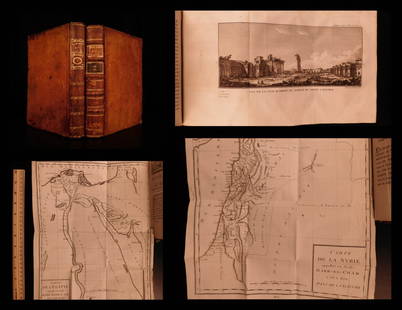
Sold20191799 Voyages in Syria & EGYPT Africa Illustrated MAPS1799 Voyages in Syria & EGYPT Africa Illustrated MAPS Sphinx Pyramids 2v Volney Constantin-François Volney, an 18th-century French philosopher known for his historical works on archaeology and travelSee Sold Price
Sold20201787 1st ed Voyages in Syria & EGYPT Africa Illustrated1787 1st ed Voyages in Syria & EGYPT Africa Illustrated MAPS Sphinx 2v Volney “The best expose of Ottoman Empire at the end of the 18th-century!” (Blackmer) Constantin-François Volney, an 18th-ceSee Sold Price
Sold2024ASSORTED MAPS US, ARABIA, EGYPT, & ETCLarge assembled 19th hand colored maps. Various countries. 1) Early 19th century folding map titled ARABIA, EGYPT, ABYSSINIA, RED SEA & Co. Published in 1817. Large map of Arabia andadjacent countriesSee Sold Price
4 days LeftTrillium Antique Prints & Rare BooksDavid Roberts - Front Elevation of the Great Temple of Aboosimble, Nubia$200
4 days LeftTrillium Antique Prints & Rare BooksDavid Roberts - The Great Sphinx, Pyramids of Gizeh$200
4 days LeftAGOPBDavid Roberts (Scottish, 1796-1864) View Under the Grand Portico, Phila, Views of Egypt and Nubia,$500
4 days LeftAGOPBDavid Roberts (Scottish, 1796-1864) The Great Sphinx, Pyramids at Gizeh, Views of Egypt and Nubia,$500
4 days LeftAGOPBDavid Roberts (Scottish, 1796-1864) Thebes, Views of Egypt and Nubia, original hand colored$500
Featured39 mins LeftJasper521814 Aaron Arrowsmith map. Israelites from Egypt to Canaan through the desert of Arabia Petraea$130
Jun 02Schilb Antiquarian Rare Books1875 1st ed ISMAILIA Central Africa Slave Trade SUDAN Egypt Illustrated Baker$1
Jun 23Schilb Antiquarian Rare Books1890 Livingstone 1ed In Darkest Africa Henry Stanley Emin Pasha Expedition MAP$16(3 bids)
1818 AuctioneersTravel. Africa. Roberts, John S. - Africa, and African Travel and Adventure, &c. London: W. P.£12(1 bid)
4 days LeftTrillium Antique Prints & Rare BooksPrevost - Chart of the Gulf of Mexico (with Florida & Lousiana)$50(1 bid)


![Egypte, Nubie et Abissinie. Egypt, Nubia & Abyssinia. Sudan. BONNE 1788 map: TITLE/CONTENT OF MAP: Egypte, Nubie et Abissinie [Egypt, Nubia and Abyssinia] DATE PRINTED: 1788 IMAGE SIZE: Approx 36.0 x 25.0cm, 14.25 x 9.75 inches (Large); Please note that this is a folding map.](https://p1.liveauctioneers.com/5584/319994/171846470_1_x.jpg?height=310&quality=70&version=1708466739)


![[MAP]. ORTELIUS, Abraham. Africae Tabula Nova. 1592. (1 of 2)](https://p1.liveauctioneers.com/197/329395/177650533_1_x.jpg?height=282&quality=70&version=1715364962)


![[MAP]. ORTELIUS, Abraham. Romani Imperii Imago. 1592. (1 of 2)](https://p1.liveauctioneers.com/197/329395/177650537_1_x.jpg?height=282&quality=70&version=1715364962)


