Sold20221855 Colton Map of Western Africa -- Africa North Western SheetTitle: 1855 Colton Map of Western Africa -- Africa North Western Sheet Cartographer: J Colton Year / Place: 1855, New York Map Dimension (in.): 14.9 X 13 in. This is a very nice map of north and westSee Sold Price
Sold2024WESTERN AFRICA.Kong Mountains.Caravan routes.Slave Coast.TALLIS/RAPKIN 1849 mapTITLE/CONTENT OF MAP: 'Western Africa' The map shows sub-saharan west Africa prior to the later "Scramble for Africa" colonisation. Senegambia is shown, as is the state of Liberia. Ashantee (roughly pSee Sold Price
Sold2023SOUTH AMERICA. North-west; map of Galapagos Isles 1907 old antique chartTitle: SOUTH AMERICA. North-west; map of Galapagos Isles 1907 old antique chart Description: South America: North-West; Inset map of Galapagos Isles' by Harmsworth (1907). Colour antique map, 50.0 x 3See Sold Price
Sold2024MOON ROCK, ENDPIECE OF A LUNAR METEORITEMOON ROCK, ENDPIECE OF A LUNAR METEORITE SAHARA DESERT, NORTHWEST AFRICA feldspathic breccia, contorted surface from impact melt, the reverse with mottled white feldspar, raised on a bespoke mount 5.5See Sold Price
Sold2021FRAMED J.H. COLTON MAP OF NORTH AMERICA CA INSETFramed engraving on paper, Map of North America from the Latest Authorities, published by J.H. Colton (Joseph Hutchins Colton, 1800-1893), No. 86 Cedar St., New York, 1846, drawn and engraved by J.M.See Sold Price
Sold2021Original Big BAGA Mask from West Africa GuineaDescription: Original Big BAGA Mask from West Africa Guinea Medium: Wood/ StrawMeasurement approximate: 30 x 20 Inches Shipping cost: $180 Different rate to California, Hawaii and Alaska appliesSee Sold Price
Sold2022A Baga Wood Nimba Mask or HeaddressA Baga Wood Nimba Mask or Headdress West Africa, Guinea, 19th-20th Century A.D. Property from the Museum of Fine Arts, St. Petersburg, Florida Provenance: Gifted in 2001 (Inv. no. T2001.031.048).See Sold Price
Sold2022Published 19th C. African Dan Wood Kagle MaskWest Africa, Liberia and Cote d'Ivoire, Dan peoples, ca. mid to late 19th century CE. A fabulous example of a wooden mask from the Dan peoples known as a "kagle" (spirit mask) enveloped in fine dark-bSee Sold Price
Sold2022Taureg woven reed carpetTaureg woven reed carpet, 20th c., Mauritania, Northwest Africa, reed bound with red, black, green, and tan dyed grass, red geometric patterns on a tan ground, approx. 176"l x 121"w Provenance: ProperSee Sold Price
Sold2022Taureg woven jute rugTaureg woven jute rug, 20th c., Mauritania, Northwest Africa, reed bound by red and black dyed grass, leather fringe, black geometric patterns on a red and tan striped ground, approx. 131"l x 96"w ProSee Sold Price
Sold2015Extremely Rare N. African Petroglyph - Ex ArnovickNorth Africa, central Sahara region, ca. 6000 BCE. This is an engraved piece of rock art that has been produced using flints to show the outline of a genderless shaman figure. The style of this pieceSee Sold Price
Sold2019A MONUMENTAL BAGA SNAKE SCULPTURE, AFRICAN ARTThis is an enormous carved wooden snake sculpture or headdress from the Baga peoples of Guinea, West Africa. The snake, known locally as Kalimbe, or Bansonyi, refers to a protective spirit manifestedSee Sold Price
Sold2017African Wooden Figural Dan SpoonWest Africa, Ivory Coast or Liberia, Dan, ca. late 19th to early 20th century CE. A skillfully hand-carved wooden feast spoon or ceremonial ladle (called a wakemia or wunkirmian meaning "spoon associaSee Sold Price
Sold2020[Maps & Atlases] [Africa] Ortelius, Abraham, Group of 2[Maps & Atlases] [Africa] Ortelius, AbrahamGroup of 2 MapsBarbariae et Biledulgerid, nova descriptio(Antwerp, ca. 1570-1612). Hand-colored engraving. Coastal map of North Africa and the Mediterranean,See Sold Price
2021Rare Dan Geh African Mask w/ Kahan Appraisal for $45kA very fine old carved wooden dance mask with attached coiffure , well handled surface patina. Dan peoples Mask, Gio/Geh, Liberia/Ivory Coast, west Africa. The mask measures and will include a customSee Sold Price
Sold2022Pacific Northwest Coast Kerfed and Bentwood Box, LatePacific Northwest Coast Kerfed and Bentwood Box, Late 19th-Early 20th C. Native American, probably an oil box, relief carved sides and shell inset rim (losses). Provenance: Ex. Collection Charles ParsSee Sold Price
Sold2022A Northwest Coast bentwood boxA Northwest Coast bentwood box Possibly Tlingit, of rectangular form, with painted formline animals on each face, including a beaver, a frog and two others, the tapering lid with inset operculum shellSee Sold Price
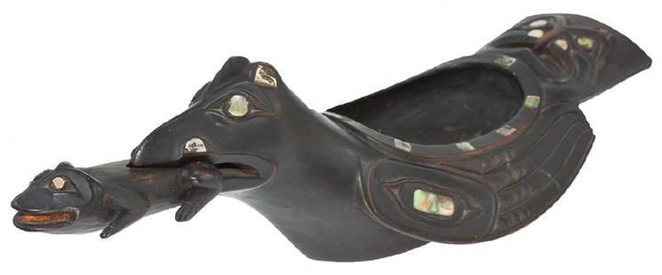
Sold201819 1/2" Haida-Tlingit Grease Bowl. Older example19 1/2" Haida-Tlingit Grease Bowl. British Columbia. Exquisite Northwest Coast, Native American, artifact. Carved Wood Bird Effigy Bowl (16 1/2") with Carved Frog (4 5/8") that insets in mouth. MotherSee Sold Price
Sold2024Pownall Map of North America with the West India IslandsPOWNALL, Thomas (1720-1805). A New Map of North America with the West India Islands, divided according to the Preliminary Articles of Peace, Signed at Versailles, 20, jan 1783, wherein are particularlSee Sold Price
Sold2024POWNALL, Thomas (1777-1805). A New and Correct Map of North America, with the West India Islands,POWNALL, Thomas (1777-1805). A New and Correct Map of North America, with the West India Islands, Divided according to the last Treaty of Peace, Concluded at Paris, 10th Feby. 1763, wherein are particSee Sold Price
Sold2024Attr. Herbert Ward (1863-1929) 8 Foot Plaster West African ArcherA more than life sized plaster figure of a West African man in loincloth, with facial scarification, with arms upraised to hold his bow. Herbert Ward (1863-1929) traveled extensively in Africa, especiSee Sold Price
Sold2022Map of United States, JH Colton, ca 1849A framed map of the United States, Map of the United States of America, The British Provinces, Mexico, the West Indies and Central America with part of New Granada and Venezuela by JH Colton, ca 1849,See Sold Price
Sold2023Scarce 1854 wall map of N. America in exceptional condition, Jacob MonkSurprisingly clean and sound wall map of North America showing significant evolution of territories west of the Mississippi River following the Mexican-American War and during the height of the CalifoSee Sold Price
Sold2023Seutter - Map of North America including Great Lakes, Florida, Virginia, New England, Mexico, WestThis engraving is from a composite atlas presented by the Homann Heirs. Many of the maps in the collection were completed by J. B. Homann, Homann Erben, M. Seutter, and T. C. Lotter. The maps were oriSee Sold Price
May 29HAMMER AUKTIONEN, African, Tribal, Oceanic & Asian Art5 Kpelle Stone Miniature Masks, "maa"CHF 5(1 bid)
10 hrs LeftJasper521892 Cowles Civil War Map of Battles in Gettysburg, Virginia, W Virginia and Maryland -- Sketch of$75(2 bids)
Jun 07Freeman's | HindmanHARMON, Daniel Williams. A Journal of Voyages and Travels in the Interiour of North America. 1820.$450(2 bids)
4 days LeftTrillium Antique Prints & Rare BooksPrevost - Chart of the Gulf of Mexico (with Florida & Lousiana)$50(1 bid)
Jun 07Freeman's | HindmanHOMANN, Johann Baptist. Amplissimae Regionis Mississipi Seu Provinciae Ludovicianae. Nuremburg, [ca$400(1 bid)


![[Maps & Atlases] [Africa] Ortelius, Abraham, Group of 2: [Maps & Atlases] [Africa] Ortelius, AbrahamGroup of 2 MapsBarbariae et Biledulgerid, nova descriptio(Antwerp, ca. 1570-1612). Hand-colored engraving. Coastal map of North Africa and the Mediterranean,](https://p1.liveauctioneers.com/65/180189/90674454_1_x.jpg?height=310&quality=70&version=1601308774)