Sold2019Antique Brass Magnifying Glass - Military Mapvintage b rass magnifying glass eye loupe military mapSee Sold Price
Sold2022Vintage Military Gun/Rifle Cleaner Kit, Uniform Belts, and Texaco Advertising CanVintage Military Gun/Rifle Cleaner Kit, Uniform Belts, and Texaco Advertising CanSee Sold Price
Sold2020Lot of Vintage Smalls incl Foreign Coins, MilitaryLot of Vintage Smalls incl Foreign Coins, Military First Aid Kit, Cap Guns , etcSee Sold Price
Sold20211861 Civil War Military Map of the U.S.Johnson's New Military Map of the United States. NY: Johnson & Browning, 1861. 17.5 x 24", in 26.25 x 32.5" frame, under glass.See Sold Price
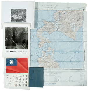
Sold2022WWII fighter pilot maps and kitHeading: (World War II) Author: Title: Fighter pilot materials from World War II Place Published: Publisher: Date Published: c.1943-1945 Description: 1 set. Includes:See Sold Price
SoldWW1.British Officers Trench Kit LotLot includes field mirror in case, trench maps of France,Sam Browne Belt with sword frog ,Trench compass and named stop watch in housing.See Sold Price
Sold2020Group of Military Used by BartholfGroup of military used by Bartholf including field binoculars, slide rule, emergency kit (not opened), pair of flip out glasses. Missing 1 lens with the generals initials, etc.See Sold Price
Sold2022Albert H. Campbell "Lee's Map Maker" Archive of Letters, Maps, & Kit!Albert H. Campbell "Lee's Map Maker" Archive of Letters, Maps, & Kit! An extensive and fascinating archive relating to Albert Henry Campbell, who was known as "General Lee's map-maker". The groupSee Sold Price
Sold2022(CIVIL WAR.) P.S. Duval & Son. Military Map of the United States & Territories(CIVIL WAR.) P.S. Duval & Son. Military Map of the United States & Territories Showing the Location of the Military Posts, Arsenals, Navy Yards, & Ports of Entry. Hand-colored lithographed pocket mapSee Sold Price
Sold2023Johnson's New Military Map of the United States. Forts Posts divisions 1861Title: Johnson's New Military Map of the United States. Forts Posts divisions 1861 Description: Johnson's New Military Map of the United States showing the Forts, Military Posts & all the Military DivSee Sold Price
Sold2021Phelps & Watson's Historical and Military Map of thePublication Date: 1863-06-29 Title: Phelps & Watson's Historical and Military Map of the Border & Southern States. Cartographer: PHELPS/WATSON Publisher: PHELPS & WATSON Height: 25.5 Width: 35.5 Map sSee Sold Price
Sold2021CIVIL WAR-ERA JOHNSON'S MILITARY MAP UNITED STATESFramed engraving with color on paper, "Johnson's New Military Map of the United States, Showing the Forts, Military Posts & c., with Enlarged Plans of Southern Harbors from Authentic Data Obtained atSee Sold Price
Sold2022Great 1863 Civil War Military Map of U. S. by Johnson & WardWhile America was involved with the Civil War, atlas publishers like Johnson and Ward produced detailed maps to capitalize on the nation’s interest in that conflict. This is the more desirable of thSee Sold Price
Sold20221789 military map of American Northeast1789 military map of American Northeast by Thomas ConderThis map was originally in the two volume book set by Thomas Anburey in this auction, lot 144. Frame: 20" x 20" Painting: 15 1/8" x 16 1/2" ThomSee Sold Price
Sold20221918 WWI FRAMED GERMAN MILITARY MAPWORLD WAR ONE BATTLE OF VERDUN FRAMED MILITARY MAP. CREASES AND STAINS. 21" x 20" MAP SIZE / 29" x 29" IN FRAME.See Sold Price
Sold2024A Scarce And Delicate Lot Of 12 WW1 Army Military Maps, Printed In 1919 By The Base Printing PlantA Scarce And Delicate Lot Of 12 WW1 Army Military Maps. Printed In 1919 By The Base Printing Plant, 29th Engineers, U.S. Army., Each Map Covers The Range Of Operation In Twelve European Locations InclSee Sold Price
Sold20231865 Colton's RR and Military Map of the US1865 "Colton's Railroad & Military Map of the United States", folding pocket map laid down on board, framed, some toning from oxidation, 32 1/2" x 42"See Sold Price
Sold2022United States military map during civil war. 1862 byTitle: United States military map during civil war. 1862 by Johnson Date/Period: 1862 Materials: Steel plate engraved Size: 19" x 27" Shows inserts of eight southern ports, interesting boundaries of tSee Sold Price
Sold20171862 Johnson Civil War Military Map of US1862 Johnson Civil War Military Map of US -- Johnson's New Military Map of the United States Showing the Forts, Military Posts &c. all the Military Divisions with Enlarged Plans of Southern Harbors…See Sold Price
Sold2022Civil War Military map - scarce territorial bordersThe Johnson and Ward atlas company produced two memorable, double-page Civil War maps of the United States. This is the more desirable issue, showing the state and territory borders instead of the MilSee Sold Price
Sold2019United States. Civil war era military map. ShowingTitle/Content of Map: United States. Civil war era military map. Showing southern ports Date: 1863 Cartographer: By Johnson & Ward. From, Johnson’s New Illustrated Family Atlas Size: 18x 26 1/4”.See Sold Price
Sold2018Johnson's New Military Map of the United States ShowingTitle: Johnson's New Military Map of the United States Showing the Forts, Military Posts &C. With Enlarged Plans of Southern Harbors Publication Date: 1864 Cartographer: JOHNSON, ALVIN JEWETT PublisheSee Sold Price
Sold20201861 Civil War military map in full hand-colorLarge format, double-page “Johnson’s New Military Map of the United States showing the Forts, Military Posts &c. with Enlarged Plans of Southern Harbors” by Johnson and Ward. Original and vividSee Sold Price
Sold2017Johnson’s New Military Map of the US, 1863Johnson’s New Military Map shows states rather than military zones. 1863. 17 x 23.75 inches. Johnson’s New Military Map of the United States Showing the Forts, Military Posts with Enlarged Plans oSee Sold Price
6 days LeftJasper52World War 2 Europe Battle of the Atlantic 1939-43 Axis Expansion limits 1959 map$15
Jun 09Worthington Galleries1705 Map LE COMBAT DE STEENKERKE [Battle of Steenkerque] by Nicolas de Fer$10
Jun 23Schilb Antiquarian Rare Books1848 Emory Military Reconnaissance 1ed California MAP Indians Texas New Mexico$3(3 bids)
6 days LeftJasper52North & West Africa. Dahomey. Gold Coast. Military Territory. THE TIMES 1922 map$20
5 days LeftFlints Auctions LtdA Military Issue M.P.P. Micro Technical VIII Large Format Camera Outfit,£320
6 days LeftPiasaJoseph Cornell (Nyack, 1903 - New York, 1972) Lunar Set (Soap Bubble Set, Lunar variant), circa 1950€200,000
Jun 08Simpson Galleries, LLC.JULIUS BIEN (1826-1909) AN AMERICAN CIVIL WAR RECONNAISSANCE MAP, "Map of Texas and Part of New$100
3 days LeftSchilb Antiquarian Rare Books1871 Alfred the Great King of England MAP Battle of Ashdown Vikings Thom Hughes$125(3 bids)
2 days LeftTrillium Antique Prints & Rare BooksDobson - Map of the World with Chart of Torrid Zone or Tropical Regions of the World$50
P.A.C.C. Auction Gallery LLCNew Unused General Model 10-100 Accessory Single Machine Hookup Kit for Dust Collector$5
6 days LeftJasper52Northwest Africa. Morocco Sahara Rio do Oro Ain Sefra Gardaia. STANFORD 1904 map$75
6 days LeftJasper52Northwest Africa. Morocco Sahara Rio do Oro Ain Sefra Gardaia. STANFORD 1904 map$75


![1705 Map LE COMBAT DE STEENKERKE [Battle of Steenkerque] by Nicolas de Fer (1 of 1)](https://p1.liveauctioneers.com/6084/330420/178181962_1_x.jpg?height=282&quality=70&version=1716391551)


![Maps of Asia & India, c1800's (2) [180164] (1 of 2)](https://p1.liveauctioneers.com/2699/331495/178785787_1_x.jpg?height=282&quality=70&version=1717094933)