Sold2016MATHEW CAREY (AMERICAN, 1760-1839) MAP OF DELAWAREMATHEW CAREY (AMERICAN, 1760-1839) MAP OF DELAWARE, hand-colored engraving on paper, titled "Delaware from the best Authorities", engraved by William Barker, published Philadelphia, 1795. Modern frameSee Sold Price
Sold20221770 MAP OF THE AMERICAS By ANTONIO ZATTAHistoric Maps Hand-Colored MAP OF THE AMERICAS, "L'America divisa Ne Suoi Principali Stati Di Nuova Projesione" by Antonio Zatta 1770 Hand-Colored Engraved MAP OF THE AMERICAS titled, "L'America divisSee Sold Price
Sold2023TWO ANTIQUE AFRICAN MAPS.Early hand colored engraved map of North Africa by Edward Wells, ca. 1700, “A New Map of the North Part of Antient Africa..” image 14.25” x 19”, overall 22” x 27”.See Sold Price
Sold2019* SAXTON, Christopher (ca 1540-ca 1610), and William* SAXTON, Christopher (ca 1540-ca 1610), and William KIP (fl.1598-1610). Flint Comitatus quem ordovices olim Incoluerunt. [London, 1607]. Hand-colored engraved map of Flint, image 265 x 320 mm (320 xSee Sold Price
Sold2017Revolutionary War Map of the Battle of SaratogaAmerican Revolution 1780 Revolutionary War Map Engraved by William Faden 1780-Dated Revolutionary War, Hand-Colored Map entitled, “Plan of the Encampment and Position of the Army Under His Excelly.See Sold Price
Sold2022(REPUBLIC OF TEXAS.) James Hamilton Young. A New Map of Texas, with the Contiguous American &(REPUBLIC OF TEXAS.) James Hamilton Young. A New Map of Texas, with the Contiguous American & Mexican States. Hand-colored engraved map of Texas with inset text panels relating information on its riveSee Sold Price
Sold2024John Speed and Francis Lamb "Map of New England and New York", ca. 1676. Hand colored engraved mapJohn Speed and Francis Lamb "Map of New England and New York", ca. 1676. Hand colored engraved map with depictions of animals such as beavers, elk, bears, foxes, and more. Vivid colors. Slight tear upSee Sold Price
Sold20231720 Handcolored Homann Map TOTIUS AMERICAE SEPTENTRIONALIS ET MERIDIONALIS NOVISSIMA REPRAESENTATIOHistoric Maps Beautiful Hand-Colored Engraved Map by Johann Homann Titled: "TOTIUS AMERICAE SEPTENTRIONALIS ET MERIDIONALIS NOVISSIMA REPRAESENTATIO..." c. 1720 Hand-Colored Map titled, "TOTIUS AMERICSee Sold Price
Sold20211757 Hand-Colored Map of Virginia and the ChesapeakeHistoric Maps Hand-Colored Map of Virginia and the Chesapeake Bay Area 1757, French and Indian War Period, Hand-Colored Engraved Map titled, "Carte De La Virginie, De La Baye Chesapeack et Pays VoisinSee Sold Price
Sold2021Early Hand-Colored Map of VeniceItaly, ca. 16th-17th century. Fine hand-colored engraved map of "Venetia" with boats in harbor and compass rose. Handsomely framed. MEASUREMENTS Sight wide: 5 7/8 / 15 cm. Sight height: 4 1/2 / 11.5 cSee Sold Price
Sold2021c 1730 Seutter Map: Novi Belgii, in America ...Historic Maps c. 1730 Historic Rare Earlier State of Seutter's Important American Northeast Map & New York City Restitutio View c. 1730 Hand-Colored Copper-Engraved Map titled, "Recens Edita totius NoSee Sold Price
Sold2023Sauthier & Fadden Revolutionary War Map EngravingAn original 18th Century hand colored engraved topographical map, illustrated by Claude Joseph Sauthier (1736–1802) and published by William Faden (1749-1836), the latter serving as royal geogrSee Sold Price
Sold20231894 hand-colored RR map of ColoradoLovely and informative, hand colored steel plate engraved railroad map of Colorado by William Bradley in 1894. From the Potter-Bradley atlas, a scarce atlas that appears to have had only one edition.See Sold Price
Sold2015Two Hand-Colored Old World MapsTwo Hand-Colored Old World Maps of England/Wales and the Americas, consisting of "Accuratissima Angliae Regni et Walliae Principatus...", engraved by Cornelis Danckerts, ca. 1690-1700, plate 20-1/2" xSee Sold Price
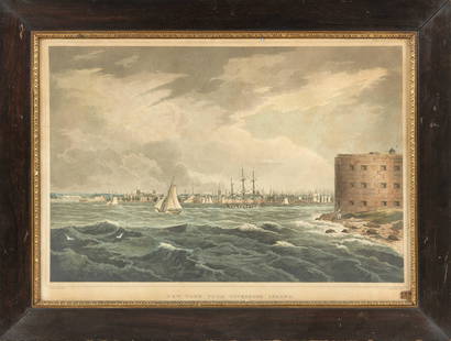
Sold2021HAND-COLORED ETCHING "NEW YORK, FROM GOVERNORS ISLAND"HAND-COLORED ETCHING "NEW YORK, FROM GOVERNORS ISLAND"After William Guy Wall (America, 1792- c. 1864). Engraved by John Hill (America, 1770-1850). Published by Henry I. Megarey, circa 1815.See Sold Price
Sold2022DES BARRES, JOSEPH FREDERICK WALLET The North East Shore of the Gulph of Mexico. London: circa 1780.DES BARRES, JOSEPH FREDERICK WALLET The North East Shore of the Gulph of Mexico. London: circa 1780. A very large hand-colored engraved map on four joined sheets. Overall 30 x 84 inches (76 x 214 cm).See Sold Price
Sold2022(NEW ORLEANS.) Benjamin Moore Norman. Norman's Plan of New Orleans & Environs.(NEW ORLEANS.) Benjamin Moore Norman. Norman's Plan of New Orleans & Environs. Finely detailed hand-colored engraved pocket map of New Orleans with an 86-point keyed reference panel. 17¾x24½See Sold Price
Sold2018Ortelius' 1570 world mapHeading: Author: Ortelius, Abraham Title: Typus Orbis Terrarum Place Published: Antwerp Publisher: Date Published: 1570-[1584?] Description: Copper-engraved map, hand-colorSee Sold Price
Sold2024Gerard Mercator (Belgian 1512 - 1594) and Rumold Mercator (Belgian 1545 - 1599)Gerard Mercator (Belgian 1512 - 1594) and Rumold Mercator (Belgian 1545 - 1599) "Orbis Terrae Compendiosa Descriptio", circa 1595 Engraved and hand colored map 14 1/2" x 19 3/4" Condition: aging, yellSee Sold Price
Sold2016Wheel of Fortune, (The), or Mother Shipton’s Book ofWheel of Fortune, (The), or Mother Shipton’s Book of Fate. London: J.L. Marks, Long Lane, West Smithfield, ca. 1820s – 30s. Publisher’s pictorial self-wrappers. Hand-colored engraved frontispiecSee Sold Price
Sold2020AUDUBON, JOHN JAMES. Great American Shrike or ButcherAUDUBON, JOHN JAMES. Great American Shrike or Butcher Bird. Plate CXCII. Hand-colored aquatint and engraved plate from Audubon's Birds of America on wove paper watermarked: "J Whatman/1834." 38½xSee Sold Price
Sold2023ORTELIUS, Abraham (1527-1598). Americae sive Novi Orbis, Nova Descriptio. Antwerp, ca 1572.ORTELIUS, Abraham (1527-1598). Americae sive Novi Orbis, Nova Descriptio. Antwerp, ca 1572. Engraved map of the Americas with hand-coloring in wash and outline, visible area 15 3/4 x 20 3/4 inches (40See Sold Price
Sold2018Young New Map of TexasA New Map of Texas with the contiguous American and Mexican States. James Hamilton Young. Engraved map with original hand color. Philadelphia: S. Augustus Mitchell, 1839. 13 x 15 1/2 inches visible, 1See Sold Price
Sold2023Jardine, William - The Naturalist's Library - 1843Jardine, William (1800-1874) The Naturalist's Library (1843) Description: Small Octavo. Edinburgh: W. H. Lizars, engraved portrait frontispieces, engraved additional titles (several hand-colored), oveSee Sold Price
4 days LeftFreeman's | Hindman[Maps & Atlases] Seutter, Matth(ias).: Novus Orbis sive America...$300(1 bid)
4 days LeftFreeman's | Hindman[Maps & Atlases] A New Map of North America, with the West India Islands...$300
3 days LeftSchilb Antiquarian Rare Books1836 Natural History Mammals Africa Buffalo Oxen Sheep Bulls Illustrated Jardine$110(7 bids)
4 days LeftFreeman's | Hindman[Fishing] Lawrence, Sir Thomas, and Thomas Rowlandson, and Paul Sandby, et al.: Album of Original An$1,500
4 days LeftFreeman's | Hindman[Natural History] Jardine, Sir William, and Prideaux John Selby: Illustrations of Ornithology$3,000
4 days LeftFreeman's | Hindman[Fishing] Allerton, R(euben) G.: Brook Trout Fishing. An Account of a Trip of the Oquossoc Angling A$275(2 bids)
5 days LeftPotter & Potter AuctionsCURTIS, Edward Sheriff (American, 1868-1952). Vash Gon - Ji...$500
4 days LeftFreeman's | Hindman[Maps & Atlases] Braun, Georg, and Frans Hogenberg: Londinum, Feracissimi Angliae...$1,000
BonhamsJOHN JAMES AUDUBON (American, 1785-1851) Two Prints; Cat Bird (Turdus Felivox) plate CXXVIIL, an...$700(3 bids)
BonhamsAfter Paul Revere, Print from 1832 Pewter Engraving of The Bloody Massacre by William F. Stratto...$2,600
BonhamsWooden Surveyor's Compass, Thomas Greenough, Sr. (1710-85), Boston, Massachusetts, c. 1765.$750(1 bid)


![* SAXTON, Christopher (ca 1540-ca 1610), and William: * SAXTON, Christopher (ca 1540-ca 1610), and William KIP (fl.1598-1610). Flint Comitatus quem ordovices olim Incoluerunt. [London, 1607]. Hand-colored engraved map of Flint, image 265 x 320 mm (320 x](https://p1.liveauctioneers.com/197/138502/70223744_1_x.jpg?height=310&quality=70&version=1553021483)


![Ortelius' 1570 world map: Heading: Author: Ortelius, Abraham Title: Typus Orbis Terrarum Place Published: Antwerp Publisher: Date Published: 1570-[1584?] Description: Copper-engraved map, hand-color](https://p1.liveauctioneers.com/642/127929/65081054_1_x.jpg?height=310&quality=70&version=1537227236)


![[Maps & Atlases] Speed, John: The Turkish Empire (1 of 2)](https://p1.liveauctioneers.com/65/332523/179335176_1_x.jpg?height=282&quality=70&version=1717709446)
![[Maps & Atlases] Seutter, Matth(ias).: Novus Orbis sive America... (1 of 2)](https://p1.liveauctioneers.com/65/332523/179335174_1_x.jpg?height=282&quality=70&version=1717709447)
![[Maps & Atlases] A New Map of North America, with the West India Islands... (1 of 2)](https://p1.liveauctioneers.com/65/332523/179335173_1_x.jpg?height=282&quality=70&version=1717709447)
![[Maps & Atlases] (Merian, M(athaus).: Constantinopolis (1 of 2)](https://p1.liveauctioneers.com/65/332523/179335171_1_x.jpg?height=282&quality=70&version=1717709445)


![[Fishing] Lawrence, Sir Thomas, and Thomas Rowlandson, and Paul Sandby, et al.: Album of Original An (1 of 5)](https://p1.liveauctioneers.com/65/332523/179335082_1_x.jpg?height=282&quality=70&version=1717622830)


![[Maps & Atlases] Speed, John: Spaine (1 of 2)](https://p1.liveauctioneers.com/65/332523/179335175_1_x.jpg?height=282&quality=70&version=1717709446)
![[Natural History] Jardine, Sir William, and Prideaux John Selby: Illustrations of Ornithology (1 of 5)](https://p1.liveauctioneers.com/65/332523/179335190_1_x.jpg?height=282&quality=70&version=1717709446)

![[Fishing] Allerton, R(euben) G.: Brook Trout Fishing. An Account of a Trip of the Oquossoc Angling A (1 of 3)](https://p1.liveauctioneers.com/65/332523/179335067_1_x.jpg?height=282&quality=70&version=1717709445)


![[Maps & Atlases] Braun, Georg, and Frans Hogenberg: Londinum, Feracissimi Angliae... (1 of 3)](https://p1.liveauctioneers.com/65/332523/179335170_1_x.jpg?height=282&quality=70&version=1717622830)


![[Fishing] Group of 8 Titles on Salmon Fishing (1 of 1)](https://p1.liveauctioneers.com/65/332523/179335096_1_x.jpg?height=282&quality=70&version=1717622830)