Sold2022Original Map of Atlantic City 1887Artist: Unknown Artist Title: Map of Atlantic City Year: 1877 Dimensions: 21in. by 31in. Edition: From the Rare Limited Edition Condition: ExcellentSee Sold Price
Sold2017Atlantic City Original Map Engraving from 1877Title: Atlantic City Medium: Original map engraving Year: 1877 Edition: From the rare limited edition COA provided. Guaranteed authentic.See Sold Price
SoldOriginal 1940's Atlantic City Boardwalk Rolling ChairOriginal 1940's Atlantic City Boardwalk Rolling Chair, Original 1940's Atlantic City Boardwalk Rolling Chair Wicker Push Cart, all original parts including canopy and cushions, significant rusting onSee Sold Price
Sold2023[CANADIAN ANTIQUE MAP] CITY [PLAN] OF QUEBEC. 1830[CANADIAN ANTIQUE MAP] CITY [PLAN] OF QUEBEC.Engraved by J.&.C. Walker.Image size (approx): 7.1/2"x9.1/4" Original engraved map, circa 1830s. Original antique map city plan, of The City of Montreal. SSee Sold Price
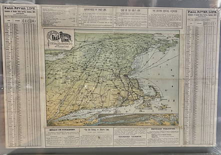
Sold2023Fall River Line, Old Colonial Railroad & Steamship Companies and CommunitiesOriginal Map. ca. 1887See Sold Price
Sold2015Railroad Ephemera & PhotosRailroad Ephemera & Photos. Including Philadelphia Steam RR map 1913, Atlantic City RR drawing, 1941 letter from Everett L. Brown, 1917, RR workers photo plus other photos of engines, stations and carSee Sold Price
Sold2021Carl Rose Original Illustration Map NY City LandmarksOriginal Carl Rose signed Illustration Pen & ink with Pencil marking for printing instructions. Carl Rose Original Illustration map OF NY City with Number Highlights Landmarks of NY city. Carl Rose (1See Sold Price
Sold2022Lot of Glass SlidesLot of glass slides including harbor scenes, schooners, shore scenes (including Atlantic City), maps, piers, Washington DC, industrial scenes, agriculture scenes, waterfalls and more! One depicting saSee Sold Price
Sold2022Lot of Glass SlidesLot of glass slides including Maryland Harbor, schooners, shore scenes (including Atlantic City), maps, battleship New Hampshire, Philadelphia piers, Washington DC, industrial scenes, agriculture scenSee Sold Price
Sold2022c.1890's Map of The Atlantic OceanOriginal c.1890's map of The Atlantic Ocean, from an 1899 edition of Leslie's Official History of The Spanish American War. Map shows submarine telegraph lines, the eastern coast of The United States,See Sold Price
Sold20211887 Map of Quebec CityAuthor: Watson Title: 1887 Map of Quebec City Medium: Ink on Paper Dimensions: 14.5"X11.5" Map of Quebec City, dated 1887. Engraved for Watson's General Atlas. Double folio map. Reference key locatedSee Sold Price
Sold20201887 Map of Quebec cityTitle: 1887 Map of Quebec city Author: Watson Medium: Ink on Paper Dimensions: 14.5"X11.5" Description: Map of Quebec city dated 1887. Part of Watson's Standard Atlas of the World. Map key located uppSee Sold Price
Sold2021MADRID Antique city town map plan Original outlineTITLE/CONTENT OF MAP: 'MADRID' The top image on the right hand side shows the entire map. To view a close up of the map showing the level of printed detail, please click on the bottom image on the rigSee Sold Price
Sold2017Cram's Map of Pittsburgh (and Allegheny City), 1887Map: Pittsburgh (and Allegheny City) Maker: George F. Cram Date: 1887 Size: 21.5 x 14.5 in Please note that this lot has a confidential reserve. When you leave a bid in advance of the auction, submitSee Sold Price
Sold2023Antique Map of Hell Gate and East River - 1887Original, extremely rare first edition map (1887), full title "Hell Gate and East River from S. End of Blackwell's Island to Lawrence's Point including Little Hell Gate and Mouth of Harlem River." ProSee Sold Price
Sold20201887 Map of LondonAuthor: Cram Title: 1887 Map of London Medium: Ink on Paper Dimensions: 22"X14.5" Map of city of London dated 1887. Double folio map engraved and published by George Cram in Chicago. Part of Cram's WoSee Sold Price
Sold2015Lipschutz signed PlacqueLipschutz signed Placque, bisque, titled "The Struggle", from Reese Palley Inc., Atlantic City, N.J. with original shipping box. c. 1976, 13 1/4" diameter. CONDITION: No issues noted.See Sold Price
Sold20221872 map of Philadelphia - Camden by S. Augustus MitchellInteresting and informative original antique map of the two cities. Large double-page map that is nicely centered. Great detail—shows individual buildings and wharves, ferries, railroads, streetSee Sold Price
Sold2023Tydol, Atlantic Road Maps, 1927 Cities Service Budget Book9"x4", soiling to the Atlantic.See Sold Price
2022Advertising poster, Jacob Ruppert's KnickerbockerAdvertising poster, Jacob Ruppert's Knickerbocker Beer", New York City map, comes in the original shipping cylinder, 21" by 28.75", on canvas.See Sold Price
Sold2021YELLOWLEG, L.R. TRUEXVERY FINE YELLOWLEG by Levi Rhodes Truex, Atlantic City, NJ. Very good original paint with some in-use scuffs. Very good structural condition with original bill professionally re-attached. Retains oneSee Sold Price
Sold2016Original KamKins DollKamkins original 18" boy, molded mask face, cloth body, original clothing 1920's Kampes Studio, Atlantic CitySee Sold Price
Sold2017Mitchell: Map of City of New York, 1849An original steel engraved map of New York City published by Augustus Mitchell in 1849, with original hand coloring. Manhattan from about 37th St with Brooklyn and Williamsburg. Key to public buildingSee Sold Price
Sold2021Vintage Map Of Greenwich Village, New York CityOriginal 1960 map of Greenwich Village, New York City by Lawrence Fahey. Stated 1st edition. Dimensions: 25" X 38" overall including frameSee Sold Price
Oct 12JM Hobby Supply and Railroad Artifact AuctionsSouthern Pacific RR One Hundred Golden Hours at Sea Book-1915$40
2 days LeftJasper52City of York #9 Minster & Medieval centre. Aldwark Monkgate Hungate. OS 1852 map$1,300
2 days LeftJasper52City of York #14 Mount Scarcroft Dringhouses Tadcaster Rd Knavesmire OS 1852 map$340
2 days LeftJasper52City of York #8 Marygate Museum Gardens Clifton Leeman Rd Bootham. OS 1852 map$440
2 days LeftJasper52City of York #15 Clementhorpe Fulford Road Skeldergate Fishergate. OS 1852 map$480
2 days LeftJasper52City of York #12 Castle Bishophill Walmgate Fossgate Hungate Aldwark OS 1852 map$1,300
2 days LeftJasper52FLORENCE FIRENZE. Antique town city map plan. Key buildings profiles. SDUK 1844$260
2 days LeftJasper52VENICE VENEZIA VENEDIG. Antique town city map plan. Environs. LARGE. SDUK 1844$460
2 days LeftJasper52VENICE VENEZIA VENEDIG. Antique town city map plan. Environs. LARGE. SDUK 1844$460
2 days LeftJasper52WARSAW WARSZAWA. Antique town city map plan. Building profiles.Colour.SDUK 1844$500


![[CANADIAN ANTIQUE MAP] CITY [PLAN] OF QUEBEC. 1830: [CANADIAN ANTIQUE MAP] CITY [PLAN] OF QUEBEC.Engraved by J.&.C. Walker.Image size (approx): 7.1/2"x9.1/4" Original engraved map, circa 1830s. Original antique map city plan, of The City of Montreal. S](https://p1.liveauctioneers.com/8321/286473/155233365_1_x.jpg?height=310&quality=70&version=1686787412)