Sold2022BRITISH ISLES Half Cents 1791-1837. A Lot of 6 Trade PiecesBRITISH ISLES Half Cents 1791-1837. A Lot of 6 Trade Pieces 1 x 1791 Liverpool W# 60 9.85 F+, 1 x 1792 Norwich John Harvey D&H# 38 VF, 1 x 1805 KM# 147 8.15 gms. VG, 1 x 1811 Isle of Man W3 2071 F, 1See Sold Price
Sold2022BRITISH ISLES LILY (GEORGE) Britanniae insulae quae nunc Angliae et Scotiae regna continet cum H...BRITISH ISLES LILY (GEORGE) Britanniae insulae quae nunc Angliae et Scotiae regna continet cum Hibernia adiacente nova descriptio, double-page engraved map, land masses hand-coloured, title cartoucheSee Sold Price
Sold2022British Isles.- Ortelius (Abraham) Britannicarum Insularum Vetus Descriptio, two-sheet map ofBritish Isles.- Ortelius (Abraham) Britannicarum Insularum Vetus Descriptio, two-sheet map of ancient Britain, probably engraved by Jan Wierix, with four ornate strap-work cartouches, a naval battle iSee Sold Price
Sold2022British Isles.- Taylor (Thomas) England Exactly Described or a Guide to Travellers, In a CompleatBritish Isles.- Taylor (Thomas) England Exactly Described or a Guide to Travellers, In a Compleat Sett of Most Correct Mapps of Counties in England ... according to Mr. Ogilby's Survey, double page tiSee Sold Price
Sold2024[British Isles] [King James I]: The Workes of the Most High and Mightie Prince, James by the Grace[British Isles] [King James I]: The Workes of the Most High and Mightie Prince, James by the Grace of God, King of Great Britaine, France and Ireland, Defender of the Faith, &c The Workes of the MostSee Sold Price
Sold2020British Isles.- Speed (John) Britain as it was DevidedBritish Isles.- Speed (John) Britain as it was Devided in the Tyme of the English Saxons especially during their Heptarchy, decorative map of the British Isles with compass rose and numerous rhumb linSee Sold Price
Sold2022BRITISH ISLES SPEED (JOHN) The Kingdome of Great Britaine and Ireland, J. Sudbury and George Hum...BRITISH ISLES SPEED (JOHN) The Kingdome of Great Britaine and Ireland, hand-coloured double-page engraved map, inset views of London and Edinburgh, decorated with putti, ships, compass and scale, RoySee Sold Price
Sold2023British Isles.- Speed (John) Britain as it was devided in the tyme of the Englishe Saxons especiallyBritish Isles.- Speed (John) Britain as it was devided in the tyme of the Englishe Saxons especially during their Heptarchy, decorative map of the British Isles with compass rose and numerous rhumb liSee Sold Price
Sold2022Anna Richards Brewster "Lake Shore, Derwentwater (British Isles)", 1925Oil on board. Unsigned with hand-written notes with title preserved verso. Framed: 10 1/2" x 13". Trained first with father William Trost Richards, later with W. Merritt Chase & LaFarge. In 2008, exhiSee Sold Price
Sold20241987 British Isles Proof Gold 1/4 ounce Angel Coin1987 British Isles Proof Gold Angel Coin. 3x3x1 in.See Sold Price
Sold20241987 British Isles Proof Gold 1/4 ounce Angel Coin1987 British Isles Proof Gold Angel Coin. 3x3x1 in.See Sold Price
Sold2017Keulen: Antique Map of the British Isles, 1678Map: British Isles Date Printed: 1678-1682 Cartographer: J Keulen Material/Medium: Paper Size: 21" x 24" Printed on thick paper. Double page map. Rare map of the British isles with north oriented to tSee Sold Price
Sold2021Jansson 1653 Map of British IslesDESCRIPTION: " Magnae Brittaniae et Hiberniae Nova Descriptio. " Based on Willem Blaeu's 1631 map of the British Isles, this map depicts towns, rivers, an inset of Orkney Islands. Strap work cartoucheSee Sold Price
Sold2020British Isles.- Ortelius (Abraham) Angliae, Scotiae, etBritish Isles.- Ortelius (Abraham) Angliae, Scotiae, et Hiberniae, sive Britannicar Insularum Descriptio, Ortelius' earliest map of Britain, oriented with north to the right, and embellished with twoSee Sold Price
Sold20241987 British Isles Proof Gold 1/4 ounce Angel Coin.1987 British Isles Proof Gold Angel Coin. 3x3x1 in.See Sold Price
Sold20241987 British Isles Proof Gold 1/4 ounce Angel Coin1987 British Isles Proof Gold Angel Coin. 3x3x1 in.See Sold Price
Sold20241987 British Isles Proof Gold 1/4 ounce Angel Coin1987 British Isles Proof Gold Angel Coin. 3x3x1 in.See Sold Price
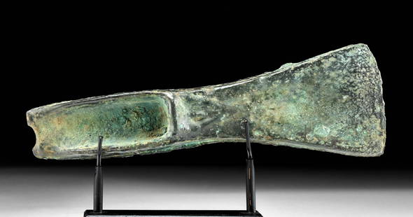
Sold2023Ancient British Isles Bronze Palstave Axe HeadAncient Northern Europe, British Isles, Atlantic Bronze Age, ca. late 2nd to early 1st millennium BCE. A mold-cast bronze axe head of sturdy design with a flared blade head and a hafting wedge meant tSee Sold Price
Sold2018Munster: Antique Ptolemaic Map of British Isles, 1570Title: Britannischen Insula. 1570 woodcut Ptolemaic map of the British Isles Map maker: Sebastian Münster Place and Year: Basel, 1570 Dimensions: 25.0 x 16.5 cm (9.8 x 6.5 in) Technique: Woodblock prSee Sold Price
Sold2019British Isles.- Mercator (Gerard) & Henricus Hondius.British Isles.- Mercator (Gerard) & Henricus Hondius. Anglia, Scotia et Hibernia, engraving with hand-colouring on laid paper, platemark 340 x 425 mm. (13 1/2 x 16 3/4 in), sheet 445 x 550 mm. (17 1/2See Sold Price
Sold2020[British Isles] [Victoria] Holmes, Richard R., Queen[British Isles] [Victoria] Holmes, Richard R. Queen Victoria New York: Century, 1897. #XCVI [96] of 100 numbered copies. Large 4to, original full brick red morocco, gilt-lettered spine, top edges giltSee Sold Price
Sold2019Compleat Map of the British Isles, Or Great Britain andTitle/Content of Map: Compleat Map of the British Isles, Or Great Britain and Ireland With Their Respective Roads And Divisions. Date: 1772 Cartographer: SAYER, ROBERT Publisher: ROBERT SAYER, Size: 2See Sold Price
Sold2022British Isles.- Duncan (James) [A New Atlas of England and Wales; Consisting of a set of largeNO RESERVE British Isles.- Duncan (James) [A New Atlas of England and Wales; Consisting of a set of large County Travelling Maps], without title, but with double-page table and 44 double-page engravedSee Sold Price
Sold2022British Isles.- Davies (Benjamin Rees) Davies's New Map of the British Metropolis, 19th century;British Isles.- Davies (Benjamin Rees) Davies's Map of the British Metropolis, showing from Shepherd's Bush to West Ham, and Camberwell to Stoke Newington, engraved map, 665 x 935 mm (26 1/4 x 36 3/4See Sold Price
2 days LeftJasper521692 Peeters Map of the British Isles -- Isles Britaniques ou sont Les Royaumes D' Angleterre D$80
6 days LeftTrillium Antique Prints & Rare BooksPtolemy & Magini, pub. 1620 - Map of the British Isles (Britain, Scotland, Ireland)$50
May 19Leonard Auction, a division of The Leonard CompanyAfter James Pollard (British, 1792-1867) Aquatint Engraving Assortment$100
210 Lots AwayBKG Antique MallMary Duchess of Ancaster by A Rainger After Sir Joshua Reynolds (British, 1723-1792) Mezzotint in$50
179 Lots AwayBKG Antique MallAfter Sir Joshua Reynolds (British, 1723-1792) Mezzotint in Color Kitty Fisher Doves$50
3 days LeftJasper52Isles Antilles Extrait des Cartes Angloises. British West Indies. BONNE 1780 map$70
3 days LeftJasper52The Consolidated Slave Act of Jamaica 1792. 40 pages. Bryan Edwards 1794 print$120


![[British Isles] [King James I]: The Workes of the Most High and Mightie Prince, James by the Grace: [British Isles] [King James I]: The Workes of the Most High and Mightie Prince, James by the Grace of God, King of Great Britaine, France and Ireland, Defender of the Faith, &c The Workes of the Most](https://p1.liveauctioneers.com/65/316312/169664667_1_x.jpg?height=310&quality=70&version=1705454340)


![[British Isles] [Victoria] Holmes, Richard R., Queen: [British Isles] [Victoria] Holmes, Richard R. Queen Victoria New York: Century, 1897. #XCVI [96] of 100 numbered copies. Large 4to, original full brick red morocco, gilt-lettered spine, top edges gilt](https://p1.liveauctioneers.com/65/159076/80332969_1_x.jpg?height=310&quality=70&version=1578427354)

![British Isles.- Duncan (James) [A New Atlas of England and Wales; Consisting of a set of large: NO RESERVE British Isles.- Duncan (James) [A New Atlas of England and Wales; Consisting of a set of large County Travelling Maps], without title, but with double-page table and 44 double-page engraved](https://p1.liveauctioneers.com/5458/255060/132669289_1_x.jpg?height=310&quality=70&version=1657897192)


