Sold20211836 Travel's Guide U.S. Map w/ Hand-Written NotesFramed Travel's Guide US Map - "Travel's Guide Through the United States, a Map of the Roads, Distances, Steam Boats & Canal Routes, by J.H. Young, Philadelphia, Published By S. Augustus Mitchell, 183See Sold Price
Sold2024Antique Albums w/ Postcards, Yosemite Photos,More - Car Photos, (1)Travel Book w/ US Map, Berkeley,Antique Albums w/ Postcards, Yosemite Photos,More - Car Photos, (1)Travel Book w/ US Map, Berkeley, Yosemite, San Francisco, YellowStone, More - Travel Album Circa 1908See Sold Price
Sold2022Vintage US Travel Destination Maps & BrochuresVintage travel destination magazines, brochures including a map for "The Mountain Empire of the West - Middle Park, Grand County, Colorado" (1934), 1940 maps of Yosemite, Yellowstone National parks asSee Sold Price
Sold20232 Travel Maps of US: Atwood Pocket Map 1851 & Williams Framed, 18541st item: PHELPS'S NATIONAL MAP OF THE UNITED STATES, TRAVELLERS GUIDE. EMBRACING THE PRINCIPAL RAIL ROADS, CANALS, STEAM BOAT & STAGE ROUTES THROUGHOUT THE UNION, by J. M. Atwood, published by ThayerSee Sold Price
Sold2021Lot of Vintage California/ West US Travel Brochures/Lot of Vintage California/ West US Travel Brochures/ Pamphlets, MapsSee Sold Price
Sold2019United StatesReserve Reduced! Title: United States Publication Date: 1832 Cartographer: KNIGHT, J. Publisher: KNIGHT, J. Size (inches): H5.3 - W6.3 Frontispiece for Darby Travel Book. Map of U.S. west to Mandan, SSee Sold Price
Sold2016French map of U.S. derived from MelishHeading: Author: Buchon, Jean Alexandre Title: Etats-Unis d'Amerique Place Published: Paris Publisher: Date Published: 1825 Description: Copper-engraved map, hand-colored.See Sold Price
Sold2024Group of Assorted Travel Guides and MapsIncludes famous American and British cities, museums, various U.S. maps and more, largest measures 11 x 8 1/2 inchesSee Sold Price
Sold2022ANTIQUE LINED MA NY VT TACONIC QUADRANGLE MAPdepartment of interior US geological survey map. has been lined and cut . current measurement 17 3/4" by 13". map shows some highlighted travel routeSee Sold Price
Sold2021Francis Hall Travels in Canada and US 1818Travels in Canada and The United States, in 1816-1817 by Lieut. Francis Hall. 1818. Republished by Wells and Lilly, London. Lacking Map and pages 11-12. 332 pp. with browning and spotting. Measures 7.See Sold Price
Sold20201887 Jules Verne Famous Travels & Travelers Voyage1887 Jules Verne Famous Travels & Travelers Voyage Exploration Illustrated MAPS “Reality provides us with facts so romantic that imagination itself could add nothing to them.” ― Jules VerneSee Sold Price
Sold2021TRAVEL AND NAVIGATION LOTTRAVEL AND NAVIGATION LOT Collection of maps, pamphlets largely from the US and Canada, Ford navigation system CD set in case (missing map 8 CD), postcards from PA, Disney World, Spain,See Sold Price
Sold2019Lot Wisconsin Travel Brochures & Maps Dells MilwaukeeLot Wisconsin Travel Brochures & Maps Dells Milwaukee etc Shipping in continental US $9.00 Please ask any questions before bidding Good Luck!See Sold Price
Sold2023OSTERREICH Austria Travel Advertising Poster. Lithograph. Map of Austria with people in native ClothOSTERREICH Austria Travel Advertising Poster. Lithograph. Map of Austria with people in native Clothes. Printed in Austria. Dimensions: H: 30.5 inches: W: 21 inches --- US Shipping charge: $35 for theSee Sold Price
Sold2023EDINBURGH Travel Advertising Poster. Graphic Map with 3D renderings of Buildings. Printed in G.B.EDINBURGH Travel Advertising Poster. Graphic Map with 3D renderings of Buildings. Printed in G.B. Dimensions: H: 40 inches: W: 25 inches: D: 7 inches --- US Shipping charge: $35 for the first poster.See Sold Price
Sold2019Lot Illinois Travel Brochures Books Map etc ChicagoLot Illinois Travel Brochures Books Map etc. See photos for details Shipping in continental US $9.00 Please ask any questions before bidding Good Luck!See Sold Price
Sold2016Lithographs of tour of U.S., Cuba & Mexico 1850Heading: (Travel Album - United States, Mexico & Cuba) Author: Title: Album of approximately 150 or more engravings, lithographs and maps gathered during a tour by land and water of Cuba, Mexico andSee Sold Price
Sold20181861 Vacation Tourists Travel Spain Fiji Illustrated1861 Vacation Tourists Travel Spain Fiji Illustrated Maps Peru Francis Galton “Poor humanity! I often feel that the tableland of sanity upon which most of us dwell, is small in area, with unfenced pSee Sold Price
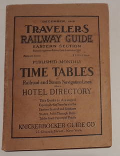
Sold20241915 Traveler's Guide Eastern US. A 344 page bookA 5 3/4" by 8" soft cover book with railroad timetables and other travel information: hotel ads, city, state maps, etc. Paper is supple and not pulpy.See Sold Price
Sold2019Lot 1950's Travel Brochures Booklets Maps etc DetroitLot 1950's Travel Brochures Booklets Maps etc . See photos for details Shipping in continental US $9.00 Please ask any questions before bidding Good Luck!See Sold Price
Sold2019Lot New York Travel Brochures Maps Letters NiagaraLot New York Travel Brochures Maps Letters Niagara Falls etc. See photos for details Shipping in continental US $9.00 Please ask any questions before bidding Good Luck!See Sold Price
Sold2019Large Lot c1950 Midwest USA Travel Brochures Maps etcLarge Lot c1950 Midwest USA Travel Brochures Maps etc. See photos for details Shipping in continental US $9.00 Please ask any questions before bidding Good Luck!See Sold Price
Sold2019Lot Virginia Travel Brochures Maps Booklets HotelsLot Virginia Travel Brochures Maps Booklets Hotels Caverns etc. See photos for details Shipping in continental US $9.00 Please ask any questions before bidding Good Luck!See Sold Price
15 hrs LeftHunt and Peck Estate Services, Inc.1849 Alex Mackay 1st US Ed. 2 Vol. "The Western World or Travels in the United States in 1846-1847"$50
May 25Cain Modern AuctionsDouble Sided U.S. Map by Rand McNally, Illustrated & Equal Area Projection$75
Featured2024Jasper52Anguilla St. Martin/Maarten Barts. Caribbean. US Navy sea chart 1899 (1917) mapSee Sold Price
7 days LeftJasper52Countries embraced within the travels of St Paul. Mediterranean. HUGHES 1856 map$20
7 days LeftJasper52Countries embraced within the travels of St Paul. Mediterranean. HUGHES 1854 map$25
15 hrs LeftHunt and Peck Estate Services, Inc.1779 J. Carver "Travels Through The Interior Parts of North-America"$50(1 bid)
Featured2024Jasper52St Vincent & "Barbadoes". Barbados. West Indies Caribbean. THOMSON 1817 mapSee Sold Price
2024Jasper52Windward Islands. Trinidad Barbados St. Lucia Grenadines. STANFORD 1896 mapSee Sold Price
2024Jasper52Amér Sep Porto Rico #69 Puerto Rico & Virgin Islands VANDERMAELEN 1827 old mapSee Sold Price
220 Lots AwayJasper52Descrittione dell' Isola di Cuba. PORCACCHI. Jamaica Hispaniola 1620 old map$150
2024Jasper52CENTRAL AMERICA. Gulf of Mexico Caribbean. Panama Canal. BARTHOLOMEW 1924 mapSee Sold Price
582 Lots AwayRapid Estate Liquidators and Auction GalleryUS Post Lewis And Clark First Day Stamp Sheet Bundle$50
2024Jasper52Leeward Islands. West Indies Virgin Antigua Dominica St. Kitts STANFORD 1904 mapSee Sold Price