Sold2016EARLY BOXED U.S. MAP PUZZLEby Mcloughlin Bros., N.Y. with fine chromolithographed lidded box with Miss Columbia and Indian child, dated 1887, with complete 37 piece chromolithographed puzzle map of the United States, box is 8 1See Sold Price
Sold2016Five Early Boxed GamesParker Brothers Hey What in O/B, Parker Brothers Pushkins Rope Race in O/B, w/missing flaps, Whitman Publishing United States puzzle map in O/B, Baurgarten & Co. tin tograph stencils in O/B, ScrabbleSee Sold Price
Sold2023Atlas Puzzle Geography 1843 H. Langois dissected mapBoxed set of 8 jigsaw puzzles published around 1843 by Hyacinthe Langlois. A wonderful example of an early nineteenth century French educational tool for teaching geography to young children.The mahogSee Sold Price
Sold2021Early U.S. map shows Texas, Upper Calif. – 1839Title: Early U.S. map shows Texas, Upper Calif. – 1839 Description: Vintage and interesting geography map showing Texas and Upper California at a time when they made up the entire southwestern UniteSee Sold Price
Sold20181839 Mitchell Map of the United StatesTitle/Content of Map: 1839 Mitchell Map of the United States -- No. 5 Map of the United States Date Printed: 1839, Philadelphia Cartographer: S Mitchell Size: 10.2 x 16.7 in. This early US map has terSee Sold Price
Sold2022Lot of 5 early orig boxed games & puzzles incl "Grandma's Bible Questions'; "Grandma's geographicalLot of 5 early orig boxed games & puzzles incl "Grandma's Bible Questions'; "Grandma's geographical Game"; "Cruelty Picture Puzzle"; "Jumbo Puzzle"; & "Picture Lotto"See Sold Price
Sold2022Vintage Wood Puzzle of U.S. Map & CapitalsVintage Wood Puzzle of U.S. Map & Capitals, measures 18 1/2 x 12 3/4 inches. Vintage, vintage wood puzzle, vintage toys, vintage toy map, wooden puzzle, 5See Sold Price
Sold20225 Boxed Early Games & PuzzlesIncludes 1889 McLoughlin ABC Blocks, taped box cover; McLoughlin 545 Pretty Village, School House Set with several paper litho folding buildings and many tin stands; 1895 McLoughlin Lotto with bag ofSee Sold Price
Sold20221889 McLoughlin Puzzle Map of the US -- A New DissectedTitle: 1889 McLoughlin Puzzle Map of the US -- A New Dissected Map of the United States Cartographer: McLoughlin Bros. Year / Place: 1889 c., New York Map Dimension (in.): 8.5 X 13 in. puzzle; 6.8 X 9See Sold Price
Sold2018Early 19th Century Cummings & Hilliard U.S. MapEarly 19th century Cummings & Hilliard U.S. map. Loose, unframed and not glued or mounted, etc. Sheet size 9.25" x 11.75". Good to very good condition. Provenance: Estate of Russell Johanson, RavennaSee Sold Price
Sold2018DISSECTED MAP OF US PUZZLEMcLoughlin Bros- litho paper on cardboard and wood; original box; complete; Box 8 1/2"x 12"; G-VGSee Sold Price
Sold2021Early English map of U.S. 1783Heading: Author: Kitchin, Thomas Title: Map of the United States in North America: with the British, French and Spanish Dominions adjoining, according to the Treaty of 1783. Place Published: London PSee Sold Price
Sold20221865 Colton Map Puzzle of the US -- Dissected Map ofTitle: 1865 Colton Map Puzzle of the US -- Dissected Map of the United States and Territories (Colton's United States of America) Cartographer: J Colton Date/Place: 1865 New York Dimensions: 10.7 X 13See Sold Price
Sold2017LARGE LOT of EARLY BLOCKS, PUZZLE and MORELot includes several late 19th early 20th century toys. Several block sets, a Bliss 19th century Croquet set in wood box, and a early McLoughlin Bros Map of the United States puzzle. Condition varies.See Sold Price
Sold20231889 c. McLoughlin World Map Puzzle and verso is a US Capitol Puzzle -- A New Dissected Map of theTitle: 1889 c. McLoughlin World Map Puzzle and verso is a US Capitol Puzzle -- A New Dissected Map of the World with a Picture Puzzle of the Capitol Cartographer: McLoughlin Bros. Year / Place: 1889 cSee Sold Price
Sold20231889 McLoughlin Puzzle Map of the US -- Dissected Map of the United StatesTitle: 1889 McLoughlin Puzzle Map of the US -- Dissected Map of the United States Cartographer: McLoughlin Bros. Year / Place: 1889 c., New York Map Dimension (in.): 8.5 X 13 in. puzzle; 6.8 X 9.4 in.See Sold Price
Sold2020Late 1800s US Army Officer Sword Hanger LotEarly boxed set of late 1800's - early 1900's US Officer sword hangers. Two hangers and the tin box they came in.See Sold Price
Sold2023Five Early Boxed Child GamesIncluding Dissected Map of the United States, McLoughlin Bros. Manuf. New York, 15 x 21" when assembled (missing several states and territories) double sides, box is wood with chromolithographed labelSee Sold Price
Sold2020Britains Set #229/3 U.S. Army Troop Display.Boxed U.S. Cavalry & Infantry Triple Row Display. Two rows of 5 peak cap Cavalry at walk & 8 Doughboys marching with Fixed Arm Officer, early paint circa 1928-1929. 18 pieces, non-catalogued set. CondSee Sold Price
Sold2023EARLY AIRSHIP PUZZLE SET w/ BOXSet of 5 early Airship Puzzles. Great images. BoxedSee Sold Price
Sold2024ASSORTED MAPS US, ARABIA, EGYPT, & ETCLarge assembled 19th hand colored maps. Various countries. 1) Early 19th century folding map titled ARABIA, EGYPT, ABYSSINIA, RED SEA & Co. Published in 1817. Large map of Arabia andadjacent countriesSee Sold Price
Sold2016J. Tallis: United States, 1851Map: United States Cartographer: J. Tallis Publishing: London, 1851 Medium: Engraving Size: 9.5 x 13.5 inches This is fantastic engraved map shows the young US republic in the early 1850's. Aside fromSee Sold Price
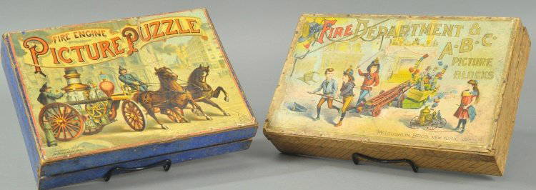
Sold2015LOT OF TWO FIRE PUZZLESMcLoughlin Bros., both boxed, includes early Fire Dept. ABC Picture blocks set, and Fire Engine Picture puzzle boxed set with sixty-eight pieces. 12" l.See Sold Price
Sold20221848 Outstanding Mexican-American War Period MapPrints 1848 Hand-Colored U.S. & Mexico Broadside & Map titled: ORNAMENTAL MAP of the UNITED STATES & MEXICO 1848-Dated, Hand-colored Lithograph Broadside with Map titled, "ORNAMENTAL MAP OF THE UNITEDSee Sold Price
Jun 02Schilb Antiquarian Rare Books1844 Sparks American Biography Zebulun PIKE US Military Voyages 5v USA$1(1 bid)
Jun 02Schilb Antiquarian Rare Books1850 David Copperfield Charles Dickens English Literature Putnam EARLY US ed$2(2 bids)
6 days LeftThomaston Place Auction Galleries(3) FRAMED PRINTS OF EARLY US NAVY SCHOONERS IN MATCHING FRAMES$100
May 25Cain Modern AuctionsDouble Sided U.S. Map by Rand McNally, Illustrated & Equal Area Projection$75
Jun 01Black Hills Curio CompanyRare 18th / 19th Century Early U.S. Marked Trade Hatchet Axe Hand Forged Black Smith Hallmarked$300
4 days LeftBaker's Antiques and AuctionsGroup of early US pennies includes Indian Head and Lincoln$40
383 Lots AwayPotter & Potter AuctionsMap to Acquaint You with the Great Mission Bay Project. 194...$125(1 bid)
2 days LeftRich Penn AuctionsCoca-Cola Items (4), Motortrike by Franklin Mint, battery op music box chest cooler/bank, boxed$50(1 bid)
2 days LeftTrillium Antique Prints & Rare BooksPtolemy & Magini, pub. 1620 - 4 Maps of the Holy Land, Palestine, Persia, Turkey, Egypt$50
2 days LeftTrillium Antique Prints & Rare BooksPtolemy & Magini, pub. 1620 - 3 Maps of part of Africa$50