Sold2016Map of Bermuda, by Hondius 1633Map of Bermuda, by Hondius 1633. Original hand colored copper engraving. Showing the "tribes" that were granted by the gentleman onboard the shipwreck that force the European settlement of the island.See Sold Price
Sold20191633 Hondius Map od Bermuda -- Mappa AestivarumReserve Reduced! Title/Content of Map: 1633 Hondius Map od Bermuda -- Mappa Aestivarum Insularum, alias Barmudas dictarum… Date: 1633, Amsterdam Cartographer: H Hondius Size: 15.5 X 20.5 in. This isSee Sold Price
Sold20221633 Hondius Map of Bermuda -- Mappa Aestivarum Insularum, alias Barmudas dictarum…Title: 1633 Hondius Map of Bermuda -- Mappa Aestivarum Insularum, alias Barmudas dictarum… Cartographer: H Hondius Year/Place: 1633, Amsterdam Dimensions: 15.5 X 20.5 in. Description: This is aSee Sold Price
Sold2024RARE 1638 HONDIUS MAP OF BERMUDA, FRAMEDHenricus Hondius (1597-1651): "Mappa Aestivarum Insularum, alias Barmudas." First atlas issue, two joined sheets as issued, copperplate engraving on wove paper with original contemporary color, printeSee Sold Price
Sold2022Lancaster.- Speed (John) The Countie Pallatine of Lancaster, described and divided into Hundreds,Lancaster.- Speed (John) The Countie Pallatine of Lancaster, described and divided into Hundreds, first edition, county map of Lancashire by Jodocus Hondius, with inset plan of Lancaster, upper right,See Sold Price
Sold2021Hondius. Nova Virginiae Tabula. 1633.[Virginia] Hondius, Henricus. "Nova Virginiae Tabula." Amsterdam, 1633. First impression with French text on verso, p 797, final catchword "peu", signature OOOOOOOO. Handcolored engraved map. DerivedSee Sold Price
Sold2024MAP, Bermuda, HondiusBermuda. Henricus Hondius, Mappa Aestivarum Insularum, Alias Barmudas Dictarum, ad Ostia Mexicani Aestuary..., from Newer Atlas..., 1638 (circa). Hand Color. A striking map based on the famous surveySee Sold Price
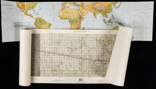
Sold2021Apollo 12: Original Apollo Lunar Orbit Map, FirstApollo 12: Original Apollo Lunar Orbit Map, First Edition October 8, 1969, Revolutions 1, 18, 19, 38, 39 and 45. Apollo 12: Conrad, Gordon and Bean, Apollo Lunar Orbit Map (ALO) First Edition OctoberSee Sold Price
Sold2022Middle East.- Escape map on silk.- War OfficeNO RESERVE Middle East.- Escape map on silk.- War Office (Geographical Section) Cairo; Alexandria - Torbuch, "restricted" military intelligence escape map, first edition, lithograph printed in coloursSee Sold Price
Sold2023Scarce First Edition Map of THE WORLD by Sidney Hall, From Black's General Atlas, 1840DescriptionScarce First Edition Hand-tinted Map Entitled THE WORLD, Engraved by Sidney Hall - From BLACK'S GENERAL ATLAS: A SERIES OF FIFTY-FOUR MAPS FROM THE LATEST AND MOST AUTHENTIC SOURCES. EngravSee Sold Price
Sold20201884 First Edition Map Cross Compton Bishop 42x29"1884 First Edition Map Cross Compton Bishop 42x29"See Sold Price
Sold2023U.S. MILITARY WWII FIELD MAPS 1943-1944(5)170300 U.S. MILITARY WWII FIELD MAPS 1943-1944(5) U.S. military WWII field maps 1943-1944 to include one original Europe Road Map Series 1 first edition France with name of soldier Caldwell, two WWIISee Sold Price
Sold20201865 Southern Rebellion Confederate Civil War Slaves1865 Southern Rebellion Confederate Civil War Slaves CSA Illustrated COLOR MAP A rare first edition of William Craft’s “The Southern Rebellion.” Crafts spends a great deal of time and effort onSee Sold Price
Sold2021Texas. A very important and rare first state firstTitle: Texas. A very important and rare first state first edition map. 1850 by Thomas. Date/Period: c1850 Size: 16 1/2 x 13 1/2 inches. Material: Hand colored steel engraved Description: A very importSee Sold Price
Sold2023Antique Map of Hell Gate and East River - 1887Original, extremely rare first edition map (1887), full title "Hell Gate and East River from S. End of Blackwell's Island to Lawrence's Point including Little Hell Gate and Mouth of Harlem River." ProSee Sold Price
Sold2023Map of the U. S. & Terr. – Rare 1st state, Mitchell 1860True first printing/first edition map from a rare atlas printed only for a short time in the early months of 1860. Samuel Augustus Mitchell, Jr. took over his father’s atlas publishing company iSee Sold Price
Sold2022Waugh (Evelyn) Black Mischief, first edition, 1932.Waugh (Evelyn) Black Mischief, first edition, map frontispiece, book label of Derek Marlowe to front free endpaper, original cloth, very light sunning to spine, light rubbing to spine tips and cornersSee Sold Price
Sold2017Tanner: Antique Map of Georgia, 1843Title/Content of Map: Georgia by Tanner Date Printed: 1843 Cartographer: based on the work of H.C. Tanner Material/Medium: Paper Size: 17" x 14" Hand colored engraved Map. From the first edition publiSee Sold Price
Sold2022Scarce 1st ed. Colton RR map of North CarolinaLovely example of North Carolina map from the first edition of Colton’s Atlas of the World. One of the few mid-19th century maps to show North Carolina independently—it was more often mappSee Sold Price
Sold2017Tanner: Antique Map of Iowa, 1843Title/Content of Map: Iowa by Tanner Date Printed: 1843 Cartographer: based on the work of H.C. Tanner Material/Medium: Paper Size: 17" x 14" Hand colored engraved Map. From the first edition publisheSee Sold Price
Sold2017Tanner: Antique Map of New York City, 1843Title/Content of Map: New York City by Tanner Date Printed: 1843 Cartographer: based on the work of H.C. Tanner Material/Medium: Paper Size: 17" x 14" Hand colored engraved Map. From the first editionSee Sold Price
Sold2017Tanner: Antique Map of Michigan, 1843Title/Content of Map: Michigan by Tanner Date Printed: 1843 Cartographer: based on the work of H.C. Tanner Material/Medium: Paper Size: 17" x 14" Hand colored engraved Map. From the first edition publSee Sold Price
Sold2017Tanner: Antique Map of Louisiana, 1843Title/Content of Map: Louisiana by Tanner Date Printed: 1843 Cartographer: based on the work of H.C. Tanner Material/Medium: Paper Size: 17" x 14" Hand colored engraved Map. From the first edition pubSee Sold Price
Sold2022Britain.- Betjeman (John) Cornwall Illustrated in a Series of Views, first edition, 1934; and 3NO RESERVE Britain.- Betjeman (John) Cornwall Illustrated in a Series of Views, first edition, map and illustrations, original spiral-bound stiff wrappers, rubbed, 1934; and 3 others first edition SheSee Sold Price
4 days LeftJasper521630 MAP OF LEDEN BELGIUM LIEGE copper engraving ANTIQUE Mercator-Hondius Atlas$50
4 days LeftJasper521816 VOYAGE TO ABYSSINIA by HENRY SALT w/ MAP antique 1st AMERICAN EDITION rare$400
May 04Bid Again Auctions (American Space Museum)NASA Lunar Orbiter V Uncontrolled Mosaic Photomap Map of Site "Schroteri's Valley"$50
May 04Bid Again Auctions (American Space Museum)NASA Lunar Orbiter V Photomap & Topographic Map of Site12 'Censorinus'$50
May 04Bid Again Auctions (American Space Museum)NASA Lunar Orbiter III Photomap & Topographic Map of Site18 'Mosting C'$50
May 04Bid Again Auctions (American Space Museum)Original Lunar Orbiter Photomap Map of Site "Copernicus"$50
May 04Bid Again Auctions (American Space Museum)NASA Lunar Orbiter V Uncontrolled Mosaic Photomap & Topographic Map of Site 'Marius"$50
May 04Bid Again Auctions (American Space Museum)NASA Lunar Orbiter V Uncontrolled Mosaic Photomap & Topographic Map of Site 'Schroteri's Valley$50
May 04Bid Again Auctions (American Space Museum)NASA Lunar Orbiter V Uncontrolled Mosaic Photomap & Topographic Map of Site "Aristarchus"$50
May 04Bid Again Auctions (American Space Museum)NASA Lunar Orbiter V Uncontrolled Mosaic Photomap & Topographic Map of Site ' Gruithuisen'$50
21 hrs LeftRapid Estate Liquidators and Auction GalleryNancy Drew #19 "The Quest Of The Missing Map" 1942 Dust Jacket First Edition$100
5 days LeftMichael Scarola Rare and Used BooksMilitary Wagon-Road In Wyoming And Montana Territories With Map Of Military Reconnaissance 1873-4$100
May 04BucklinMagdanz, Andreas; Dienststelle Marienthal [2000 1ST EDITION & 1ST PRINTING LIMITED EDITION 1/1500 -$80
19 hrs LeftTrillium Antique Prints & Rare BooksDe Jode, pub. 1593 - Map of Hesse, Germany (Hessiae Seu Cattorum Nobilissimorum?)$100
19 hrs LeftTrillium Antique Prints & Rare BooksDe Jode, pub. 1593 - Map of part of Germany (Reiterata Episcopatus Monasteriensis geographica?)$100


![Hondius. Nova Virginiae Tabula. 1633.: [Virginia] Hondius, Henricus. "Nova Virginiae Tabula." Amsterdam, 1633. First impression with French text on verso, p 797, final catchword "peu", signature OOOOOOOO. Handcolored engraved map. Derived](https://p1.liveauctioneers.com/179/209052/106367556_1_x.jpg?height=310&quality=70&version=1624651037)