Sold2017Hand-Colored Lithograph Map of the Gulf of MexicoImpressive Hand-Colored Lithograph Map of the Gulf of Mexico, titled "U.S. Coast Survey, A.D. Bache Superintendent, Sketch H, Showing the Progress of the Survey in Section No. 8, 1846-1854", the map iSee Sold Price
Sold20201778 Handcolored Map West Indies Gulf of Mexico1778 "The West Indies and Gulf of Mexico from the Latest and Best Observations", by John Lodge. Hand colored map. Fine, measures 15 x 9". Reserve: $80.00 Shipping: Domestic: Flat-rate of $5.00 to anywSee Sold Price
Sold2022JOHN TALLIS (1817-1876) A 'GOLD RUSH' MAP, "Mexico,JOHN TALLIS (1817-1876) A 'GOLD RUSH' MAP, "Mexico, California and Texas," LONDON, EDINBURGH AND DUBLIN, CIRCA 1851, hand-colored lithograph on paper, "The Illustrations by H. Warren & Engraved by J.See Sold Price
Sold2023Samuel A. Mitchell Hand Colored Lithograph MapSamuel Augustus Mitchell, American (1792-1868). Hand colored lithograph of Mexico, Central America, West Indies, 1860. Mounted in silver tone wood frame and includes paperwork. Measures 20"H x 27.75"WSee Sold Price
Sold202319th C. Maps, West Indies Gulf of Mexico (3pc)Three Hand Colored 19th C. Maps of The West Indies, Gulf of Mexico: (1) Map titled "CARACCAS AND GUYANAS" Published 1822, Sherwood Neely & Jones, London, good condition, measures: 8.5"H x 10.5" W, (1)See Sold Price
Sold2017Colton: Antique Map of Mexico, 1871Title/Content of Map: Mexico by Colton Date Printed: 1871 Cartographer: G.W. Colton Material/Medium: Paper Size: 17 1/4" x 14 1/2" Hand colored lithograph. From 'Colton's American Atlas'. Published inSee Sold Price
Sold2020Homann Heirs Map of the West Indies and Mexico 17Homann Heirs, "Mappa Geographica complectens I. Indiae Occidentalis Partem Mediam Circum Isthmum Panamensem," Nuremberg, 1740. Hand colored map of the Gulf Coast, Florida, and the Caribbean, with inseSee Sold Price
Sold20221848 Outstanding Mexican-American War Period MapPrints 1848 Hand-Colored U.S. & Mexico Broadside & Map titled: ORNAMENTAL MAP of the UNITED STATES & MEXICO 1848-Dated, Hand-colored Lithograph Broadside with Map titled, "ORNAMENTAL MAP OF THE UNITEDSee Sold Price
Sold2022Buache & Dezauche - Map of the Gulf of MexicoPhilippe Buache & Jean André Dezauche, Carte du Golphe du Mexique et des Isles Antilles..., Paris, circa 1780, engraving on laid paper with hand colored highlights, plate 19-3/4 x 36-7/8 in., sheetSee Sold Price
Sold2023Antique 18th C Map of the Gulf of Mexico, M. Rizzi ZannoniM. RizziZannoniMapofthe Gulfof Mexico, Caribbean, and parts of Central America, hand-colored engraving on paper, titled "Carte Geo-Hydrographique du Golfe de Mexico Et Des Ses Isles". Published in ParSee Sold Price
Sold2020AN ANTIQUE MAP, "New Railroad Map of the United States,AN ANTIQUE MAP, "New Railroad Map of the United States, the Dominion of Canada, Mexico and the West Indies," CHICAGO, CIRCA 1875, hand-colored lithograph on paper, publishing, engraving, and printingSee Sold Price
Sold2023RARE BUCHOLTZ-LUDWIG ANTEBELLUM POCKET MAP OF VIRGINIARARE BUCHOLTZ-LUDWIG ANTEBELLUM POCKET MAP OF VIRGINIA, hand-colored lithograph, Map of the State of Virginia Containing the Counties, Principal Towns, Railroads, Rivers, Canals & All Other Internal ISee Sold Price
Sold2020Essex House Press57. Essex House Press.Hensman, Mary. Dante Map. Fine hand-colored lithograph map. 21 x 34 inches, linen-backed, folding into original cloth binder with accompanying text pamphlet; some shelf-wear, minSee Sold Price
Sold201818TH CENTURY MAP OF VENEZIA, ITALYAntique hand-colored lithograph map reads, "I Contorni, di Venezia di Nuova Projezione Venezia, 1784, Presso Antonio Zatta e Figli con Privilegio dell'Eccmo Senato." Map measures 15¾" x 12" visibleSee Sold Price
Sold2023Williamson, Lieut. R. S. 1856 HC Map. San Diego & Colorado River California"Geological Map of the Country Between San Diego and the Colorado River California" By W. P. Blake. Hand Colored Lithograph Map Published 1853-61, Washington for "Reports of explorations and surveys,See Sold Price
Sold2022Colton & Johnson C1870 Pair of Large Maps of Turkey"Turkey in Europe" and "Austria, Turkey in Europe and Greece" Hand Colored Lithograph Maps Published C1856-70's, New York for "Colton's Atlas Of The World" by J. H. Colton and "Johnson's New IllustratSee Sold Price
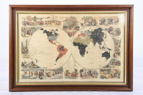
Sold2021PICTORIAL MISSIONARY MAP OF THE WORLDHand colored lithograph featuring map of the globe with vignettes of the introduction of Christianity in various cultures of the world, published in 1861, sight size 18 3/4 x 28 3/4 inches, set in oriSee Sold Price
Sold2024J.H. Colton and Co., Map of Mexico, 1854Framed hand-colored map of Mexico and the Southwest, published by J.H. Colton and Company in 1854 sight: 13 x 16 in., sheet: 15.5 x 19.5 in., matting 20 x 22 in. Shipping available for this lot throuSee Sold Price
Sold2020Mercator-Hondius Mexico Map ca. 1638Hendrik Hondius (1588-1651), Jan Jansson (1588-1664), and Gerardus Mercator (1512–1594), "Nova Hispania et Nova Galicia," Amsterdam: Hondius & Jansson, ca. 1638. Hand colored map of Mexico fromSee Sold Price
Sold2022Compton & Dry, 1875, Topographical Survey, St. Louis, Downtown, Plate #74Compton & Dry, 1875, Topographical Survey, St. Louis, Downtown, Plate #74Hand-colored lithograph, topographical map of downtown St. Louis in 1875 showing 18th to Jefferson streets and Saint Louis Ave.See Sold Price
Sold20181773 Hand Colored Bellin Map of MexicoHandcolored map of Mexico by Jacques Bellin, circa 1773, printed at Amsterdam. Fine condition, measures 16.5 x 10.5”. Please note that this lot has a confidential reserve. When you leave a bid in adSee Sold Price
Sold20231842 MATHER & SMITH WALL MAP OF LONG ISLAND, NYHand-colored lithograph. "A Geological Map of Long & Staten Islands with the Environs of New York"; William W. Mather, geologist and J. Calvin Smith, surveyor. This landmark pre-Civil War map is the eSee Sold Price
Sold2022(REPUBLIC OF TEXAS.) John M. Niles; and Lorraine T. Pease. A Map of Mexico and the Republic of(REPUBLIC OF TEXAS.) John M. Niles; and Lorraine T. Pease. A Map of Mexico and the Republic of Texas. Hand-colored engraved map of Mexico, an independent Texas, and part of the American southeast. 13&See Sold Price
Sold2020Willem Blaeu Map of Guinea ca. 1631Willem Janszoon Blaeu (1571-1638), "Guinea," Amsterdam, ca. 1631. A hand colored map of the Gulf of Guinea region of Africa, including what is now Guinea, Sierra Leone, Liberia, Cote d'Ivoire, Ghana,See Sold Price
May 25Cain Modern AuctionsChristian Riese Lassen Hand Embellished Lithograph Signed, Artist Proof$800
2 days LeftTrillium Antique Prints & Rare BooksMathews, Australia - Pair of Bird Lithographs (Red-cheeked Parrot & Masked Gannet)$50
2 days LeftTrillium Antique Prints & Rare BooksDiggles, Australia - Laughing Jackass or Great Brown Kingfisher$75