Sold2018Vintage Auto Advertising and Map LotGMC, Gulf, Esso, Shell, Sunoco, Plymouth, 1940 Classical Lands Mediterranean Map, 1939 Atlantic Ocean map, Boston and moreSee Sold Price
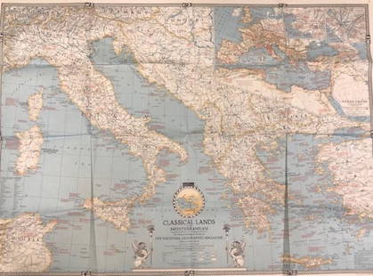
Sold2020Vintage National Geographic MagazineDescription: Vintage paper map from National Geographic Magazine, depicting the classical lands of the Mediterranean. Copyright 1940. Material: paper. Measurement: approximate 26.5"h x 34"w (INCHES).See Sold Price
Sold2016c. 1670 Engraved Holy Land + Mediterranean MapHistoric Maps c. 1670 Engraved Map of the Holy Land & Mediterranean Sea c. 1670, Historic Hand-Colored Engraved Map entitled: “Terra Sancta sive Promissionis olim Palestina recens delineata,” by FSee Sold Price
Sold20221940 MEDITERRANEAN SEA. WW2 Naval Bases. Italian Dodecanese Albania 1940 mapTITLE/CONTENT OF MAP: 'Mediterranean Sea: Communications and Naval Bases' DATE PRINTED: March 1940 IMAGE SIZE: Approx 27.0 x 44.0cm, 10.5 x 17.25 inches (Large) TYPE: Vintage colour map; Scale 1:10,00See Sold Price
Sold2018Mediterranean & Black Sea. Cables & Wireless Stations.TITLE/CONTENT OF MAP: 'The Mediterranean and Black Sea - Cables and Wireless Stations; Inset The Mediterranean and Black Seas showing the Visibility of the Land' DATE PRINTED: c1914 IMAGE SIZE: ApproxSee Sold Price
Sold2022Mediterranean & Black Seas. Cables. Land visibility. Shipping lines 1959 mapTITLE/CONTENT OF MAP: 'The Mediterranean and Black Seas - Communications inset Visibility of the Land' DATE PRINTED: 1959 IMAGE SIZE: Approx 35.0 x 46.5cm, 13.75 x 18.25 inches (Large) TYPE: Antique cSee Sold Price
Sold2022Mediterranean & Black Seas. Cables. Land visibility. Shipping lines 1927 mapTITLE/CONTENT OF MAP: The Mediterranean and Black Sea - cables and wireless stations [inset Visibility of the Land] DATE PRINTED: 1927 IMAGE SIZE: Approx 35.0 x 46.5cm, 13.75 x 18.25 inches (Large) TYSee Sold Price
Sold2022Mediterranean & Black Sea. Cables & Wireless Stations. Land visibility 1918 mapTITLE/CONTENT OF MAP: 'The Mediterranean and Black Sea - Cables and Wireless Stations; Inset The Mediterranean and Black Seas showing the Visibility of the Land' DATE PRINTED: 1918 IMAGE SIZE: ApproxSee Sold Price
Sold2023USC&GS Map, Fowey Rocks to American Shoal, Florida KeysA color map showing the land and sea area of Fowey Rocks to American Shoal. Publishing stamp by "The U.S Coast and Geodetic Survey" located on bottom. Issued: 1940 Dimensions: 38.5"L x 34"W MaSee Sold Price
Sold2023USC&GS Map, Fowey Rocks to American Shoal, Florida KeysA color map showing the land and sea area of Fowey Rocks to American Shoal. Publishing stamp by "The U.S Coast and Geodetic Survey" located on bottom. Issued: 1940 Dimensions: 38.5"L x 34"W MaSee Sold Price
Sold2022Impressive 1st ed. map of Palestine from J. H. Colton, 1855Detailed map of the Holy Land, colored by tribes and showing scripture names, classical names, modern names, roads, rivers, towns, villages, mountains, etc. Includes the modern-day nations of Israel,See Sold Price
Sold20171861 Johnson's Map of PalestineItem: 1861 Johnson's Map of Palestine Description: Map of the Holy Land showing topographical and settlement details. Names are font-coded as to being scripture, classical or modern names. Inset are aSee Sold Price
Sold2021Map of Palestine in Classical Era (Hughes)Scarce map of Palestine (Israel) or the Holy Land in antiquity. Centered on the Jordan River, the map covers the regions between modern-day Israel and Lebanon with parts of Syria and Jordan. Inset atSee Sold Price
Sold2018Maps 18th-19th Century. Mixed Lot of 23Mixed Lot of Maps, mostly 19th Century Lithographed. Incl UK, South America, Syria, Germany, France, Caribbean, USA, Panama, Europe, Holy Land, Italy, Mediterranean, Cambridge, Ludlow, Pacific, Asia aSee Sold Price
Sold2022Framed Nicolas de Fer Four Grand Monarchies PrintDESCRIPTION: Framed color print of a map entitled "The Four Great Monarchies of the Assyrians, the Persians, the Greeks, and the Romans" by Nicolas de Fer depicting the lands around the MediterraneanSee Sold Price
Sold2021Terra Sancta Holy Land Map with the Borders of the 12Terra Sancta Holy Land Map with the Borders of the 12 Tribes of Israel, Nuremberg, 1707. Johann Baptista Homann (German, 1664-1724). Title: Iudaea seu Palaestina ob sacratissima Redemtoris vestigia hoSee Sold Price
Sold2022Early 18th cent Holy Land Map of JerusalemVisscher, after Nicolaum (Nicolaes) (Dutch, 1618-1679), Die Heylige und Weitberuhmte Stadt Jerusalem Erstlich Genant Salem, antique map, c. 1710s, published in a German bible by Johann Detleffsen, a sSee Sold Price
Sold2020Promised Land Map LotLot of two maps of the Holy Land: 1. "A map of the Land of Promise Compiled by the Author out of the Book of Joshua". Hand-colored copperplate engraving. From: Calmet, Augustin Antoine. A historical,See Sold Price
Sold2020Antique Johnson and Ward "Holy Land" MapDESCRIPTION: map of the Holy Land, based upon the 12 tribes and contemporary (to mid-19th Century) borders. Insets of view of Damascus and town plan of Jerusalem. Shows towns, roads, rivers, lakes, moSee Sold Price
Sold2023Moxon, Joseph 1711 Holy Land Map of the Travels of St. Paul"The Travels of St. Paul and other the Apostles..." Copper Engraved Map Published 1711, London for "The History of the Old and New Testament Extracted out of Sacred Scripture" by Le Sieur de RoyaumontSee Sold Price
Sold2022Early 18th cent Holy Land Map of Middle EastVesscher, after, Die Gelegenheit des Paradeis und des Lands Canaan, Sambt den Erst Bewohnten Landeren der Patriarchen..., antique map, c. 1710s, published in a German bible by Johann Detleffsen, a sliSee Sold Price
Sold2018Harenburg / Homann: Holy Land Map with Tribal DivisionsMap: Palaestina in XII tribus divisa Cartographer: Harenburg/Homann Heirs Place/Date: Nurnberg / 1750 Size: 20 1/2" x 18 3/4" Condition: tribal areas in wash color, the rest of the map and cartouchesSee Sold Price
Sold2022Theodore Danckerts (Dutch, 1663-1727) - Holy Land Map Divided to Tribes, Etching, Amsterdam, CaTheodore Danckerts (Dutch, 1663-1727) - The Holy Land Map Divided to Tribes, Colored Etching, Amsterdam, Circa 1690. Title: Judaea sive Terra Sancta quae Israelitarum In Suas Duodecim Tribus DestincatSee Sold Price
Nov 12J. Greenstein & Co., Inc.A LARGE GROUP OF 11 SOLID SILVER CUPS. Austrian, c. 1900. Each with a depiction of the kotel.$150
3 days LeftJasper52Land Classification Map of Part of Eastern New Mexico. Atlas Sheet No. 84 (B.)$120
4 days LeftJasper52Chagos Islands Peros Banhos Egmont Salomon EAST INDIA CO. chart 1839 (1940) map$300
6 days LeftHeritage Auctions35025: Frederick Judd Waugh (American, 1861-1940) Land'$2,000
4 days LeftJasper52LONDON UNDERGROUND tube map plan diagram. Northern Heights SCHLEGER/ZERO #1 1940$300
4 days LeftJasper52LONDON UNDERGROUND tube map plan diagram. Northern Heights SCHLEGER/ZERO #2 1940$340
4 days LeftJasper52LONDON UNDERGROUND tube map plan diagram. Northern Heights SCHLEGER/ZERO #1 1940$300
4 days LeftJasper52SALISBURY PLAIN War Department land. MOD Training area. Ordnance Survey 1908 map$440
Oct 05North American Artifact AuctionsAncient Holy Land Bronze Bracelet - 1st Century BC to 7th Century AD$10(1 bid)
Oct 06Life Antiques LimitedMedieval- Holy Land Bronze Ring with West Syriac Cross, Circa 10th-13en Century AD£60
Oct 06Life Antiques LimitedMedieval Holy Land Bronze Cross Pendant, Circa 10th-12th Century AD.£20(1 bid)
Oct 06Life Antiques LimitedMediaeval Crusaders- Holy Land Cross Pendant, Circa 9th-10th Century AD£80


![Mediterranean & Black Seas. Cables. Land visibility. Shipping lines 1927 map: TITLE/CONTENT OF MAP: The Mediterranean and Black Sea - cables and wireless stations [inset Visibility of the Land] DATE PRINTED: 1927 IMAGE SIZE: Approx 35.0 x 46.5cm, 13.75 x 18.25 inches (Large) TY](https://p1.liveauctioneers.com/5584/267896/140242824_1_x.jpg?height=310&quality=70&version=1668549165)


