Sold2019Bartholomew, John 1922 Lot 5 Maps of Britain & IrelandIncl British Isles Political, British Isles Railways, Scotland South, Scotland North, Ireland North Section, Ireland Southern Section. Large Lithograph Maps Published 1922 by The Times, London for "ThSee Sold Price
Sold2021Bartholomew, John 1904 Lot of 4 Railway Maps UK IrelandRailways of Scotland, Ireland, England & Wales, and General Map of the British Isles with Railway & Steamship Routes. Lithograph Map Published 1904, London for "The Survey Gazetteer of the British IslSee Sold Price
Sold2021Bartholomew, John 1889 Lot of 5 World, Europe MapsIncl Natural Productions, Chart of the World of showing Heights and Depths, Sketch Chart of the North Atlantic, Railway Map of Central Europe, and Railway Map of British Isles. Lithograph Maps PublishSee Sold Price
Sold2020[POCKET MAPS] A lot of 3 engraved maps[POCKET MAPS] Lot of 3 engraved maps, each dissected and mounted to linen, including: W.H. Smith & Son's. "Railway Map of the BritishIsles." London. Blue cloth binding. ** "New Coloured Chart of ThameSee Sold Price
Sold2018Rare And Important British Isle Of Man Suppertable, carved mahogany with shoe feet and bird cage tilt construction, 19 th Century, 34 dia x 29 h, excellent conditionSee Sold Price
Sold2018AN "ORIENT MAKE" LEATHER TRIMMED LUGGAGE SUITCASE,AN "ORIENT MAKE" LEATHER TRIMMED LUGGAGE SUITCASE, 1900-1950, BRITISH ISLES, the multi toned leathers with machine stitched and riveted construction with reinforced corners, the top with two brass locSee Sold Price
Sold2019Philip, George C1895 Lot of 7 British County MapsIncl Scotland, Scotland Railways, South Wales, North Wales and British Isles. Lithograph Maps Published C1895 by George Philip & Son, London for "Phillips' Atlas of the British Isles" Centre fold as iSee Sold Price
Sold2022BRITISH ISLES LILY (GEORGE) Britanniae insulae quae nunc Angliae et Scotiae regna continet cum H...BRITISH ISLES LILY (GEORGE) Britanniae insulae quae nunc Angliae et Scotiae regna continet cum Hibernia adiacente nova descriptio, double-page engraved map, land masses hand-coloured, title cartoucheSee Sold Price
Sold2016ASTER BRITISH RAILWAYS A4, SIR NIGEL GRESLEYELO Aster; German; B.R. A4; London Northeastern Railway (L.N.E.R.) 4-6-2-; Sir Nigel Gresley; No. 60007; 1 Gauge; Engine-18”; Tender-10"See Sold Price
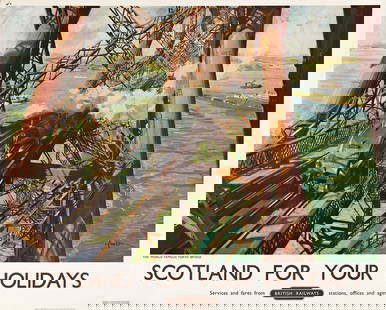
Sold2023TERENCE CUNEO (1907-1996). SCOTLAND FOR YOUR HOLIDAYS / BRITISH RAILWAYS. 1952. 40x50 inches, 101&#TERENCE CUNEO (1907-1996) SCOTLAND FOR YOUR HOLIDAYS / BRITISH RAILWAYS. 1952. 40x50 inches, 101½x127 cm. Waterlow, London. Condition A- / B+: minor repaired tears at edges; minor creases and abrSee Sold Price
Sold2022British Isles.- Ortelius (Abraham) Britannicarum Insularum Vetus Descriptio, two-sheet map ofBritish Isles.- Ortelius (Abraham) Britannicarum Insularum Vetus Descriptio, two-sheet map of ancient Britain, probably engraved by Jan Wierix, with four ornate strap-work cartouches, a naval battle iSee Sold Price
Sold2022British Isles.- Taylor (Thomas) England Exactly Described or a Guide to Travellers, In a CompleatBritish Isles.- Taylor (Thomas) England Exactly Described or a Guide to Travellers, In a Compleat Sett of Most Correct Mapps of Counties in England ... according to Mr. Ogilby's Survey, double page tiSee Sold Price
Sold2024[British Isles] [King James I]: The Workes of the Most High and Mightie Prince, James by the Grace[British Isles] [King James I]: The Workes of the Most High and Mightie Prince, James by the Grace of God, King of Great Britaine, France and Ireland, Defender of the Faith, &c The Workes of the MostSee Sold Price
Sold2020British Isles.- Speed (John) Britain as it was DevidedBritish Isles.- Speed (John) Britain as it was Devided in the Tyme of the English Saxons especially during their Heptarchy, decorative map of the British Isles with compass rose and numerous rhumb linSee Sold Price
Sold2022BRITISH ISLES SPEED (JOHN) The Kingdome of Great Britaine and Ireland, J. Sudbury and George Hum...BRITISH ISLES SPEED (JOHN) The Kingdome of Great Britaine and Ireland, hand-coloured double-page engraved map, inset views of London and Edinburgh, decorated with putti, ships, compass and scale, RoySee Sold Price
Sold2021A British Railways poster, Cornwall, Travel by Train.A British Railways poster, Cornwall, Travel by Train. Depicting a Cornish cove, after a painting by Jack Merriott. Printed by Jordison & Co. Ltd., London and Middlesbrough. Approx. 39 1/4" x 25"See Sold Price
Sold2024MTH o scale British Railways 4-6-2 Duchess of AthoMTH o scale British Railways 4-6-2 Duchess of Atholl steam engine with proto-sound 2.0 (hi-rail wheels)- 20-3371-1. Locomotive tested but did not run - may need new batteries; comes with original box;See Sold Price
Sold2021A 1930s BRITISH RAILWAYS ADVERTISING POSTERThe full-color lithograph with illustration by Frederick Taylor (1875-1963) reads LINCOLN BY LNER, IT'S QUICKER BY RAIL,' signed The London & North Eastern Railway, John Waddington Ltd. Leeds & LondonSee Sold Price
SoldTERENCE CUNEO (1907-1996) ROYAL BORDER BRIDGE, British RailwaysTERENCE CUNEO (1907-1996) ROYAL BORDER BRIDGE, British Railways lithographic poster in colours, printed by Chromoworks, London, cond. A, backed on linen, 40 x 50in. (102 x 127cm.) For further informatSee Sold Price
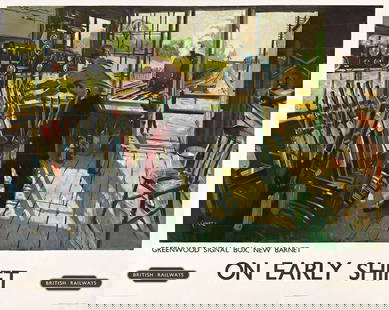
Sold2023TERENCE CUNEO (1907-1996). ON EARLY SHIFT / BRITISH RAILWAYS. 1948. 39¾x50 inches, 101x127 cm.TERENCE CUNEO (1907-1996) ON EARLY SHIFT / BRITISH RAILWAYS. 1948. 39¾x50 inches, 101x127 cm. Waterlow and Sons, Ltd., London. Condition B / B-: extensive replaced losses, overpainting and repairSee Sold Price
Sold2023British Isles.- Speed (John) Britain as it was devided in the tyme of the Englishe Saxons especiallyBritish Isles.- Speed (John) Britain as it was devided in the tyme of the Englishe Saxons especially during their Heptarchy, decorative map of the British Isles with compass rose and numerous rhumb liSee Sold Price
Sold2022Anna Richards Brewster "Lake Shore, Derwentwater (British Isles)", 1925Oil on board. Unsigned with hand-written notes with title preserved verso. Framed: 10 1/2" x 13". Trained first with father William Trost Richards, later with W. Merritt Chase & LaFarge. In 2008, exhiSee Sold Price
Sold20241987 British Isles Proof Gold 1/4 ounce Angel Coin1987 British Isles Proof Gold Angel Coin. 3x3x1 in.See Sold Price
Sold20241987 British Isles Proof Gold 1/4 ounce Angel Coin1987 British Isles Proof Gold Angel Coin. 3x3x1 in.See Sold Price
May 16Potter & Potter AuctionsYork In Daffodil Time / British Railways. 1950. Great Brita...$50(1 bid)
23 hrs LeftTrillium Antique Prints & Rare BooksPtolemy & Magini, pub. 1620 - Map of the British Isles (England, Scotland, Ireland) / Verso: Map of$50(1 bid)
4 days LeftJasper521824 Cary Map of the British Isles -- Cary's Reduction of his Six Sheet Map of the British Isles;$320
Featured5 days LeftJasper52PACIFIC OCEAN currents British French German US Spanish colonies. LETTS 1889 map$15
May 04Trillium Antique Prints & Rare BooksBlaeu?s Le Theatre du Monde? ? Volume 3 with 57 Fold Out Maps with Original Hand-coloring, 4 Smaller$1,000
3 days LeftClaydon Auctioneers LtdBooks: A quantity of books on the subject of nature to include Wayside and Woodland Blossoms, by£50


![[POCKET MAPS] A lot of 3 engraved maps: [POCKET MAPS] Lot of 3 engraved maps, each dissected and mounted to linen, including: W.H. Smith & Son's. "Railway Map of the BritishIsles." London. Blue cloth binding. ** "New Coloured Chart of Thame](https://p1.liveauctioneers.com/1124/187577/94368885_1_x.jpg?height=310&quality=70&version=1607095126)


![[British Isles] [King James I]: The Workes of the Most High and Mightie Prince, James by the Grace: [British Isles] [King James I]: The Workes of the Most High and Mightie Prince, James by the Grace of God, King of Great Britaine, France and Ireland, Defender of the Faith, &c The Workes of the Most](https://p1.liveauctioneers.com/65/316312/169664667_1_x.jpg?height=310&quality=70&version=1705454340)