Sold2018Roux, Joseph C1790 Antique Map of Algiers, AlgeriaCopper Engraved Map Published C1790, Paris for "Recueil Des Principaux Plans des Ports et Rades de la Mer Mediterranee" by Joseph Roux. Paper Size: 11.5 x 8.5 inch (29 x 22cm) Water stain in bottom maSee Sold Price
Sold2022Antique Print - Map of Rhodes - Aegean Islands - Dodecanese Greece - Joseph RouxOriginal copper engraving print originates from ”Recueil des Principaux Plans des Ports et Rades de la Mer Mediterranee …” by Joseph Roux of the edition of 1804. The charts are engraSee Sold Price
Sold2022Antique Print - Map of Gramvousa Island - Crete - Gramvousa Greece - Joseph RouxOriginal copper engraving print originates from ”Recueil des Principaux Plans des Ports et Rades de la Mer Mediterranee …” by Joseph Roux of the edition of 1804. The charts are engraSee Sold Price
Sold2022Antique Print - Map of Adakoy Koyu - Ankara - Turkey - Asia Minor - Joseph RouxOriginal copper engraving print originates from ”Recueil des Principaux Plans des Ports et Rades de la Mer Mediterranee …” by Joseph Roux of the edition of 1804. The charts are engraSee Sold Price
Sold2022Antique Print - Map of ancient Knidos - Triopion & Cavo Crios - Turkey - RouxOriginal copper engraving print originates from ”Recueil des Principaux Plans des Ports et Rades de la Mer Mediterranee …” by Joseph Roux of the edition of 1804. The charts are engraSee Sold Price
Sold2022Antique Print - Map of The Port of Tilos - Aegean Islands - Greece - Joseph RouxOriginal copper engraving print originates from ”Recueil des Principaux Plans des Ports et Rades de la Mer Mediterranee …” by Joseph Roux of the edition of 1804. The charts are engraSee Sold Price
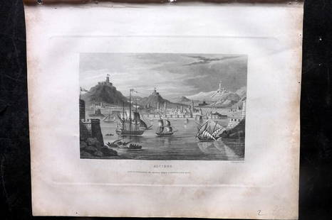
Sold2023Barclay, James 1834 Antique Print. Algiers, Ships, AlgeriaSteel Engraving Published 1834 by Thomas Kelly, London for "A New and Universal English Dictionary" by the Rev. James Barclay. Maps Drawn & Engraved by Alexander Findlay. Paper Size: 10.5 x 8 inch (27See Sold Price
Sold2021LAPIE ORIGINAL ANTIQUE MAP ALGERIA TUNISIA TRIPOLI 1829Original Carte De La Barbarie -Maroc - D'Alger, De Tunis, De Tripoli 1829 SIZE: 25.5 X 20 INCHES APPROX. UNFRAMEDSee Sold Price
Sold2023Vintage Photographs Claude Joseph Portier - Algiers, Albumen, Algeria c. 1870Photographs Claude Joseph Portier - Algiers, Albumen, Algeria c.1870 Albumen print glued on cardboard 25 x 19 cm Reserve: $50.00 Shipping: Domestic: Flat-rate of $15.00 to anywhere within the contiguoSee Sold Price
Sold2022Antique Map Print - South Africa - Algeria - Egypt - PalestineSet of 4 Map Prints. Antique lithographic map originates from "Letts's Popular Atlas", being a series of maps delineating the whole surface of the globe, with many special and original features; and aSee Sold Price
Sold2022Antique Map of Africa - Nigeria - Ethiopia - Algeria - Kenya - Samuel John NeeleA new map of Africa from the best authorities, 1791. Technique: Engraving. Artist: Samuel John Neele. Place: London, England. Size: 10” x 8” inches / 25 cm x 21 cm.See Sold Price
Sold2023Meyer, Joseph 1898 Mixed Lot of 9 Antique MapsIncl Ornithology Map, Central Europe, German Republic, West Indies, Winds, Historical and Classical Maps and others. Lithograph Maps Published 1893-98, Leipzig and Vienna for "Meyers Konversations-LexSee Sold Price
Sold2023Venezuela, New Granada & Ecuador by J.W. Lowry. Colombia 1859 old antique mapTitle: Venezuela, New Granada & Ecuador by J.W. Lowry. Colombia 1859 old antique map Description: Venezuela, New Granada, and Ecuador' by Joseph Wilson Lowry (1859). Antique engraved atlas map with orSee Sold Price
Sold2017Colton: Antique Map of United States of America, 1864Map: Colton's United States of America. Unusual Idaho Includes Colored, Un-named Montana and Wyoming - Rare Publication Date: 1864 Authors: J.H. COLTON, COLTON, JOSEPH HUTCHINS Publisher: J.H. COLTONSee Sold Price
Sold2023Colton's Central America. Decorative antique map. Honduras Guatemala 1869Title: Colton's Central America. Decorative antique map. Honduras Guatemala 1869 Description: Colton's Central America' by Joseph Hutchins Colton (1869). Antique engraved hand coloured atlas map, 33.5See Sold Price
Sold2021Antique Map ETHNOGRAPHISCHE KARTE VON EUROPA, J. MeyerAntique Map ETHNOGRAPHISCHE KARTE VON EUROPA (German)(Translated: Ethnographic Map of Europe), Joseph Meyer (1796-1856) | Map shows the various races/peoples as they are spread throughout Europe. ThisSee Sold Price
Sold2018Young: Antique Map of the Interior of Africa, 1828Title/Content of Map: Map of the Interior of Africa Date Printed: 1828 Cartographer: YOUNG, J. H./JOSEPH C. HART Size (inches): 12.5x14.75 "Drawn & engraved to illustrate HART'S geographical exercisesSee Sold Price
Sold2017Colton: Antique Map of Southern Italy, 1857Title: Map of Southern Italy by Colton Date: 1857 Dimensions (inches): 17 x 14 Medium: Hand Colored Lithograph Condition: Small rips along bottom and right side Joseph Hutchins Colton (1800 - 1893), kSee Sold Price
Sold2017Delaporte: Antique Map of Poland Reserve, 1787Title/Content of Map: Poland Reserve Date Printed: 1787 Cartographer: Joseph Delaporte Material/Medium: Paper Size: 9 1/2" x 7 1/4" From the Atlas Ou Collection De Cartes. Geographiques Pour L'intelliSee Sold Price
Sold2020Fenning & Collyer 1765 Antique Map of Europe"A New & Accurate Map of Europe" Copper Engraved Map Published 1764-65, London for "A New System of Geography: or, A General Description of the World" by Daniel Fenning & Joseph Collyer. Maps by G. RoSee Sold Price
Sold2017Colton: Antique Map of Denmark & Iceland, 1860Title/Content of Map: Denmark with insert of Iceland Date Printed: 1860's Cartographer: J H. Colton Material/Medium: Paper Size: 14" x 17" Hand colored. Published in New York City. Joseph Hutchins ColSee Sold Price
Sold2017Colton: Antique Map of West or Upper Canada, 1861Title/Content of Map: Colton's Canada West or Upper Canada Date Printed: 1861 Cartographer: Colton Material/Medium: Paper Size: 17" x 14" Hand colored steel engraved. Published in New York. Joseph HutSee Sold Price
Sold2017Colton: Antique Map of Germany, 1857Title: Map of Germany by Colton Date: 1857 Medium: Hand Colored Lithograph Dimensions (in.): 17 x 14 Joseph Hutchins Colton (1800 - 1893), known professionally as J.H. Colton, founded an American mapmSee Sold Price
Sold2017Colton: Antique Map of France, 1857Title: Map of France by Colton Date: 1857 Dimensions (inches): 14 x 17 Medium: Hand Colored Lithograph Condition: Good Condition Joseph Hutchins Colton (1800 - 1893), known professionally as J.H. ColtSee Sold Price
Featured20 hrs LeftJasper52The Bahamas, Cuba & Bermuda "or Summer Islands". THOMSON 1817 old antique map$180
May 17Albion AuctionsGentleman's Magazine 1778 Canal Map. Belfast to Loughneagh Northern Ireland$5(1 bid)
3 days LeftTrillium Antique Prints & Rare BooksPrevost - Map of Japan with part of Korea and China$50