Sold2019Chastenet-Puységur: Large Hispaniola Chart, 1787Cartographer: Chastenet-Puységur/Dépôt de la Marine Place/Date: Paris / 1787 Size: 37 1/4" x 23 1/2" Condition: beautifully colored; split in upper margin and border and along bottom centerfold expSee Sold Price
Sold2017Chastenet-Puysegur: Antique Map of Hispaniola, 1787Map: Carte Réduite de l'Isle de St. Domingue Cartographer: Chastenet-Puységur/Dépôt de la Marine Place & Date: Paris / 1787 Size: 37 1/4" x 23 1/2" Condition: b&w; light overall age toning; left mSee Sold Price
Sold2022Large chart of Strait of Magellan 1787Heading: (South America) Author: Schraembl, Franz Anton Title: Karte der Magellanischen Strasse von Herrn Don Iuan de la Cruz Cano y Olmedillo... Place Published: Wien Publisher:Jos. Gerstner DatSee Sold Price
Sold2018Depot de la Marine: Lower Bahamas to Hispaniola CoastMap: Carte Réduite des Débouquements de St. Domingue Cartographer: Chastenet-Puységur/Dépôt de la Marine Place/Date: Paris / 1787 Size: 37" x 23" Condition: b&w; overall age toning; some minor spSee Sold Price
Sold20181875 Imray Nautical Chart of Hispaniola -- HaitiReserve Reduced! Title/Content of Map: 1875 Imray Nautical Chart of Hispaniola -- Haiti Date: 1875, London Cartographer: J Imray Size: 25.5 X 39.4 in. This is a large, atractive, blue-back nautical chSee Sold Price
Sold2023Large chart of Pacific & Indian Oceans 1813Heading: Author: Espinosa y Tello, Josef Title: Carta general para las navegaciones a la India Oriental por el Mar del Sur y el Grande Oceano que separa el Asia de la America Place Published: LondonSee Sold Price
Sold2016Large chart of the Azores 1755Heading: Author: Depot de la Marine Title: Carte Réduite des Isles Açores pour servir aux Vaisseaux du Roi Dréssée au Dépôt des Cartes, Plans, et Journeaux de la Marine... Place Published: [ParSee Sold Price
Sold2021George Eldridge, Large Chart of Chesapeake Bay 1868George Eldridge / G. W. Boynton, Sc., ELDRIDGEÕS CHART OF CHESAPEAKE BAY, JAMES, YORK, RAPPAHANNOCK AND POTOMAC RIVERS. Compiled from the latest surveys by GEORGE ELDRIDGE, HYDROGRAPHER. Boston: S. TSee Sold Price
Sold2018Bellin: Large Hispaniola MapThe first edition of Bellin's spectacular, large scale map of Hispaniola. Its meticulous topographical and nautical detail makes this one of the major 18th century maps of Hispaniola.; RS2608; Bellin;See Sold Price
Sold2018Bellin: Large Hispaniola MapMap: Carte de l'Isle de Saint Domingue. Cartograper: Bellin Place / Date: Paris / 1764 Size: 36 1/2" x 22 3/8" Condition: "wash color; overall age toning and some spotting, more concentrated in the maSee Sold Price
Sold2018Iceland.- Bellin (Jacques Nicolas) Carte Reduite deIceland.- Bellin (Jacques Nicolas) Carte Reduite de l'Islande et des Mers qui en sont Voisines ..., large chart of Iceland with the Faroe Islands in the lower right corner, extensive title and descripSee Sold Price
Sold2022Martha’s Vineyard, 1855 Coastal SurveyPainstakingly hand-colored large chart showing Martha’s Vineyard and the Falmouth area of Cape Cod. Minutely detailed with hundreds of soundings shown. “Preliminary Chart of Muskeget ChannSee Sold Price
Sold2022Nystrom Anatomical Roll Out Chart Muscles 1918,ScienceNystrom Anatomical Roll Out Chart Muscles 1918. Marked Copyright 1918, A.J. Nystrom & Co Publishers, Chicago, American Edition, Chart No. 2, large chart shows the muscles of the human body. FascinatinSee Sold Price
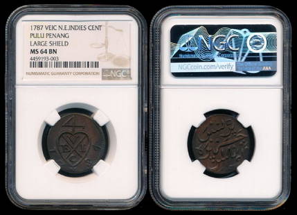
Sold2018Malaysia Pulu Penang 1c 1787 large shieldMalaysia Pulu Penang, Cent, (KM.4), 1787, VEIC, large shield, NGC MS64BN. From the Peninsula Collection.See Sold Price
Sold2023Large 1876 chart of Long Island Sound from Newport to New York. Compiled by George Eldridge, publishLarge 1876 chart of Long Island Sound from Newport to New York. Compiled by George Eldridge, published by S. Thaxter & Son, Boston. Nautical chart with notable coastal towns and landmarks. Canvas backSee Sold Price
Sold20231770 Large Printed Chart of the Troops of FranceColonial America 1770 Dated, "Carte Des Troupes De France, Sur Le Pied Des Ordonnances 1770" ("Chart of the Troops of France, Based on the Ordinances of 1770" 1770-Dated, Pre-Revolutionary War AmericaSee Sold Price
Sold20181740 Large Folding Chart Western AtlanticA New Map of Chart of the Western or Atlantic Ocean with part of Europe Africa and America: Shewing the Course of the Galleons, Flota, and C to and from the West Indies, London, printed for E. Cave atSee Sold Price
Sold2019Chatelain, Zacharie 1708 Large Genealogy Chart"Carte Genealogique de la Maison de Brunsuick-Lunebourg, ses differentes branches ses Titres et ses Pretentions" Copper Plate Published 1705-20, Amsterdam for "Atlas Historique, Ou Nouvelle IntroductiSee Sold Price
Sold20201787 Large Folding Map of AfricaAfrica Drawn from the latest and best Authorities, published at London by Harrison and Co., 1787. Fine, measures 19.5 x 16". Reserve: $30.00 Shipping: Domestic: Flat-rate of $5.00 to anywhere within tSee Sold Price
Sold2019Chatelain, Zacharie 1708 Large Genealogy Chart"Trophee Eleve a la Gloire des Premiers Heros de la Liberte Germanique" Copper Plate Published 1705-20, Amsterdam for "Atlas Historique, Ou Nouvelle Introduction A L'Histoire" by Zacharie Chatelain. PSee Sold Price
Sold2023Perry, Matthew 1856 Large Map. Chart of the World. Track of the U.S Steam Ships"Chart of the World showing the Track of the U. S. Steam Frigates Mississippi, Susquehanna, and Powhatan" Large Folio Lithograph Map Published 1856, Washington for "Narrative of the Expedition of an ASee Sold Price
Sold2019Chatelain, Zacharie 1708 Large Genealogy Chart"Genealogie de la Maison d'Anhalt, ses differentes Branches, ses Titres, ses Armes, et ses Alliances" Copper Plate Published 1705-20, Amsterdam for "Atlas Historique, Ou Nouvelle Introduction A L'HistSee Sold Price
Sold2019Sanson & Jaillot 1700 Lot of 17 Large Atlas ChartsCharts and Tables describing the Towns of a particular country. Incl Austria, Poland, Ottoman & Turkish Empire, British Isles, French Antilles, Mediterranean, Scotland, Ireland, Portugal, Bohemia, RusSee Sold Price
Sold2021North PacificTitle: North Pacific Publication Date: 1868 Cartographer: IMRAY, JAMES F. Publisher: JAMES IMRAY & SON Description: Comprehensive large sea chart of Japanese and Alaskan waters with copious soundingsSee Sold Price
4 days LeftJasper521699 Moll World Map with Cowley's Voyages -- Nouvelle Carte du Monde Suivant l'idee de Mercator ou$240
4 days LeftJasper521850 Sacramento and San Joaquin Rivers Chart -- Chart of Suisun & Vallejo Bays with the Confluence$200
5 days LeftJasper52Hawaiian–Emperor seamount chain Midway-Kauai ADMIRALTY chart 1950 (1955) map$140
5 days LeftJasper52South Pacific Ocean. French Polynesia Cook Islands. US Navy sea chart 1895 map$130
5 days LeftJasper52Marshall Islands North Pacific Ocean Micronesia ADMIRALTY chart 1891 (1953) map$120
5 days LeftJasper52Caroline Islands Palau Malakal Ngulu Angaur. ADMIRALTY sea chart 1928 (1956) map$120
5 days LeftJasper52South west Pacific Ocean Melanesia Polynesia ADMIRALTY sea chart 1875 (1968) map$120
5 days LeftJasper52Pacific Ocean sea chart. Ports lighthouses mail routes dockyards LARGE 1952 map$30
5 days LeftJasper52Pacific Ocean sea chart. Ports lighthouses mail routes dockyards LARGE 1959 map$35
5 days LeftJasper52Pacific Ocean sea chart. Ports lighthouses mail routes dockyards LARGE 1927 map$35
5 days LeftJasper52Nouvelle Caledonie. Baies de Kuakue et de Uinne'. CHAMBEYRON sea chart 1891 map$100