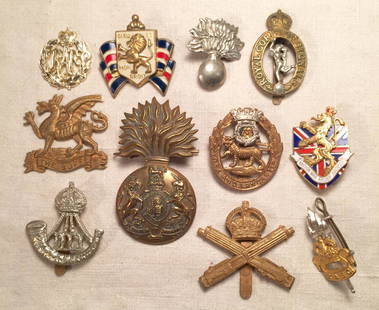
Sold2022WWII British & Canadian Army & RAF Royal Air Force Cap Badges Lot of 37Large lot of WWII - post War British and Canadian Military Army and Royal Air Force type badges with various maker marks. Overall good condition.See Sold Price
Sold2022WWII British & Canadian Army & Royal Air Force RAF Cap Badges Lot of 38Large lot of WWII - post War British and Canadian Military Army and Royal Air Force type badges with various maker marks. Overall good condition.See Sold Price
Sold2021German Offensive On the Somme - March 1916 MapGerman Offensive On the Somme - March 1916 World War I One. Linen backed. Map 6 - Ordnance Survey - Large Map with Scale Publisher British Dated: 1919 Type:See Sold Price
Sold2021Battle of the Somme - 1916 MapBattle of the Somme - 1916 World War I One. Linen backed. Map 1 - Ordnance Survey - Large Map with Scale Publisher British Dated: 1919 Type: Colored MiltSee Sold Price
Sold2021Battle of Cambrai - Nov. Dec. 1917 MapBattle of Cambrai - November December 1917 World War I One. Linen backed. Map 5 - Ordnance Survey - Large Map with Scale Publisher British Dated: 1919 TypeSee Sold Price
Sold2021Third Battle of Ypres 1917 MapThird Battle of Ypres - Summer and Autumn 1917 World War I One. Linen backed. Map 4 - Ordnance Survey - Large Map with Scale Publisher British Dated: 1919 TSee Sold Price
Sold2021Final British Offensive August - November 1918 MapFinal British Offensive August to November 1918 World War I One. Linen backed. Map 8 - Ordnance Survey - Large Map with Scale Publisher British Dated: 1919See Sold Price
Sold2021The German Offensive on the Lys - April 1918 MapThe German Offensive on the Lys - April 1918 World War I One. Linen backed. Map 7 - Ordnance Survey - Large Map with Scale Publisher British Dated: 1919 TypSee Sold Price
Sold2021The German Retreat to the Hindenburg Line 1916 MapThe German Retreat to the Hindenburg Line 1916 - 1917 World War I One. Linen backed. Map 2 - Ordnance Survey - Large Map with Scale Publisher British Dated: 1919</See Sold Price
Sold2018Geological Map of the British Islands based on the workGeological Map of the British Islands based on the work of the Geological Survey by E.B. Bailey Director 3rd Edition 1939 , published in colour by the Ordnance Survey Office September 1941 Scale 25 miSee Sold Price
Sold2017[World War One - Maps] WWI Military Maps of North West[World War One - Maps] WWI Military Maps of North West Europe, Belgium and France, Lot of 3 Three Military maps issued by the British Army, Geographical Services. Typical topographic maps with towns,See Sold Price
Sold2022(Early 20th c) MAPS OF EUROPE / MANY WARTIMEBataille de la Marne, French and British Front 1917, Ordnance Surveys Loughborough, Derby, Rickmansworth, Nouveau Plan de Paris Monumental N.B. circa 1890, printed by Defrenoy (Paris, France), overallSee Sold Price
Sold2017WWI WWII British Pins and Medals RAF & MoreLot of 11 English pins, medals and decorations. Including RAF sew-on, The Buffs East Kent Regiment sew-on, WWI Royal Scots Fusiliers Infantry, WWI Yorkland Lancaster Regiment Infantry, Royal Army EducSee Sold Price
Sold2023INTERESTING WW2 STAMPED PRESENTATION ENGLISH MILITARY GRADE KNUCKLESOriginal British WWII knuckle duster bearing army ordnance WD war department marks the name of the owner and stamped 1944. Authentic WW2 example, significantly worn and shows patches of pittingSee Sold Price
Sold2020WWII 1943 British East Anglia Air Force Map24 inch x 29.5 inch map of East Anglia produced by the British War Office and used by RAF and US Pilots. This one belonged to Brigadier General Jesse Auton, Cpommander of an 8th AAF Fighter Wing in WWSee Sold Price
Sold2020WWII 1942 British East Anglia Air Force Map24 inch x 29.5 inch map of East Anglia produced by the British War Office and used by RAF and US Pilots in 1942. This one belonged to Brigadier General Jesse Auton, Cpommander of an 8th AAF Fighter WiSee Sold Price
Sold2018Normandy/Ile de France. World War 2 pre-D-Day militaryTITLE/CONTENT OF MAP: 'North west Europe. Rouen-Paris - Army/Air. Sheet 7' The map was published by the (British) War Office in 1943, with magnetic north dated to June 1943 - a year before the D-Day lSee Sold Price
Sold2023WWII RAF Royal Air Force Deenethorpe Airfield & Vicinity 8th Air Force MapWWII RAF Royal Air Force Deenethorpe Airfield & Vicinity 8th Air Force Map. Deenethorpe was constructed in 1943 and was allocated to the United States Army Air Forces Eighth Air Force. It was assignedSee Sold Price
Sold2016Malaya, WWII, British Army PropagandaMalaya, WWII, British Army Propaganda, 1944-45, $10, Block MN, “Wang Jepun Akan Mati Bersama 2 Jepan”, Tan J19, KNB16. PMG AU 55 EPQ 马来亚, 二战, 英国See Sold Price
Sold2023WORLD WAR II FIFTH ARMY BATTLE MAPS OF ITALIAN MAINLANDExcellent collection of 19 battle maps, many apparently battle-used, all U.S. Army issue in 1943 and stamped with the name of their owner, Major Raymond Kenny, Co. D, 2675th Regt., A.C.C. This regimenSee Sold Price
Sold2024WWI British Named Officer's Sword And Coat Of Arms With Patent Document Grouping.WWI British Named Officer's Sword And Coat Of Arms Patent Document Grouping. Named To Captain Wilfred Johnson Banham Of The Indian Army Reserve Of Officers. (1) Pattern 1897 Officer Sword. Single EdgeSee Sold Price
Sold2022Framed Original WWII Your Job Is To Keep 'Em Shooting!Your Job Is To Keep 'Em Shooting! is a 1942 World War II U.S.A propaganda poster by Herbert Morton Stoops. The artwork was commissioned by the United States Army Ordnance Division. The image demonstraSee Sold Price
Sold2020WW2 BATTLE OF THE BULGE AMERICAN STAR FIELD MARKERWorld War II Battle of the Bulge American Star Field Marker Painting on canvas. Diameter 33". (Cut, As found) . Along with a Canvas Map case, Group of Yank: The Army Weekly 1943 Magazines.See Sold Price
Sold2017William Faden, rare Revolutionary War Map of NYWilliam Faden, rare Revolutionary War Map of NY, William Faden (British, 1749-1836), "A Plan of the Operations of the Kings Army under the Command of General Sr. William Howe, K.B. in New York and EasSee Sold Price
3 days LeftHunt and Peck Estate Services, Inc.1798 Bryan Edwards "The History Civil and Commercial of the british colonies in the west indies$50
May 16Zikorn Arts & History ObjectsWest Indies, Providence, Windward, Cuba 1834 British Admiralty Map$100(1 bid)
May 16Zikorn Arts & History ObjectsEntrance to Baltic Great & Little Belt 1852 British Admiralty Map$100
5 days LeftZevantiquesWWII British special forces assassin’s pen – mostly used by British SOE agents$400(3 bids)
5 days LeftZevantiquesEarly WW2 British 2 nd Pattern Fairbairn Sykes fighting knife issued to US Airborne serviceman$1,000
May 19Rich Penn AuctionsMilitaria, Pilot's Aviation Cap & Goggles, WW2 British, goggles stamped Stadium Made in England, cap$60(2 bids)
May 25Eagles Corps International LLCWW2 WWII Ordnance painted M1 Front Seam Fixed Bale helmet with Inland Liner$6(2 bids)
5 days LeftWorthington GalleriesRare Antique Hand-colored Engraving OFFICERS OF THE BRITISH ARMY, NO. 57$40


![[World War One - Maps] WWI Military Maps of North West: [World War One - Maps] WWI Military Maps of North West Europe, Belgium and France, Lot of 3 Three Military maps issued by the British Army, Geographical Services. Typical topographic maps with towns,](https://p1.liveauctioneers.com/46/113409/58240767_1_x.jpg?height=310&quality=70&version=1512492316)