Sold2023VERY RARE WALL MAP OF THE CITY OF BANGOR,PENOBSCOT COUNTY, MAINE. 1853, Bangor, Maine. "Published Under the Patronage of the City Government Henry F. Walling, Civil Engineer, 81 Washington St. Boston 1853". "S.S. Smith, Publisher 17 West MarSee Sold Price
Sold2018Ireland - Roque, John 1762 Large Rare Wall Map"A Map of the Kingdom of Ireland Divided into Provinces, Counties and Baronies" Large Copper Engraved Map with original hand colour. Published 1762 by Robert Sayer. 4 Joined Sheets to form one large mSee Sold Price
Sold2023Scarce 1854 wall map of N. America in exceptional condition, Jacob MonkSurprisingly clean and sound wall map of North America showing significant evolution of territories west of the Mississippi River following the Mexican-American War and during the height of the CalifoSee Sold Price
Sold20191755 Three Panel Wall Map of South America BoltonRare three panel wall map of South America “Performed Under the Patronage of Louis Duke of Orleans .. by the Sieur D’Anville, Improved by Mr. (Samuel) Bolton for Mr. Postlethwayt’s Dictionary ofSee Sold Price
Sold2021Rare set H.C. Tunison Wall MapsHeading: Author: Tunison, Henry Cuthbert Title: Tunison’s Twentieth Century Series of School Maps Place Published: Jacksonville, IL Publisher:H.C. Tunison, Publisher Date Published: c.1905See Sold Price
Sold2019Huge/clean 1867 wall map of North America, J. T. LloydHuge antique wall map in rare condition...varnish appears nearly fresh with absolutely no cracking. Includes original rollers which are also in great condition. Great hand-coloring and strong print. TSee Sold Price
Sold2016Wall Map Rockland County New York, 1854WALL MAP ROCKLAND COUNTY NEW YORK, 1854 Surveyed and Published by R.F.O' Connor, New York Dimension: 46.6" x 34" Condition: Good , no stains or repairs. General handling wear. Provenance: Private EstaSee Sold Price
Sold20231854 MAPS Atlas 1ed World in Middle Ages CRUSADES Rome Ottoman Medieval Koeppen1854 MAPS Atlas 1ed World in Middle Ages CRUSADES Rome Ottoman Medieval Koeppen Adolph Ludwig Koeppens “World in the Middle Ages” is a rare, 19th-century perspective on the state of the woSee Sold Price
Sold20241854 California 1ed LAWS Congress Gold Rush American West 3v Sacramento RARE1854 California 1ed LAWS Congress Gold Rush American West 3v Sacramento RARE A collection of legislature reports from the State of California in the 1850s. Following the goldrush of the late 1840s, anSee Sold Price
Sold20211854 HUGE MAP 1ed California Gold Rush Baldwin Complete1854 HUGE MAP 1ed California Gold Rush Baldwin Complete Gazetteer Americana Thomas Baldwin’s ‘Complete Gazetteer’ is a mid-19th-century book describing a comprehensive history of the United StatSee Sold Price
Sold2021H/C Map of France The Treaty of Paris, Charles SmithRare Antique Hand-Colored Map Entitled France According to The Treaty of Paris (1814) | Plate 14, Copper Plate Engraving | Cartographer : Charles Smith (1768 - 1854); Smith, Charles & Son (active 1800See Sold Price
Sold20181854 Elisha Kane Arctic Explorations Voyages Franklin1854 Elisha Kane Arctic Explorations Voyages Franklin Grinnell Expedition Map The Arctic Exploration, or ‘Advance,’ led by Elisha Kent Kane, was financed to find Sir John Franklin and his ship whiSee Sold Price
Sold20191854 Journey to Central Africa EGYPT Sudan Ethiopia MAP1854 Journey to Central Africa EGYPT Sudan Ethiopia MAP Nile Bayard Taylor Bayard Taylor was a 19th-century travel writer whose abundant notes and reports have been referenced for decades since the miSee Sold Price
Sold20221854 Arctic Explorations Voyages Franklin Grinnell Expedition Map Elisha Kane1854 Arctic Explorations Voyages Franklin Grinnell Expedition Map Elisha Kane The Arctic Exploration, or Advance, led by Elisha Kent Kane, was financed to find Sir John Franklin and his ship which wasSee Sold Price
Sold2015Rare Book, "Gibbsons Fall of the Roman Empire"Gibbson, Edward, "Gibbsons Fall of the Roman Empire". Elbemarle St: London, 1854. all eight volumes are in good condition and all maps are present and have good color. Main Line Philadelphia Private CSee Sold Price
Sold2022George Nakashima, Rare Wall CaseGeorge Nakashima Rare Wall Case Nakashima StudioUSA, 1960East Indian rosewood, printed paper 12.25 h × 40.25 w × 12 d in (31 × 102 × 30 cm) Case features exceptioSee Sold Price
Sold2023Le Corbusier, Rare wall lampLe Corbusier Rare wall lamp GuiluxSwitzerland/France, 1952-59painted aluminum, brass 5.25 h x 9.75 w x 5.25 d in (13 x 25 x 13 cm) Provenance: Collection of Michael andSee Sold Price
Sold2015A Fine & Rare Map of New York.Bernard Ratzer "Plan of the City of New York". Signed lower right in the plate "T. Kitchin Sculpt" (Kitchin recorded the cartographer's name as Ratzen (sic) rather than Ratzer). The map backed, rolledSee Sold Price
Sold2022Rare map of Chinatown, San Francisco, 1929Heading: -1929 Author: Wong, J.P. Title: Map of San Francisco Chinatown / ????????: ??? / Meiguo Sanfan Shi hua qiao qu: xiang xi tu Place Published: San Francisco Publisher: Date Published:See Sold Price
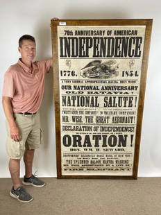
Sold2022Rare 1854 Declaration of Independence BroadsideThis rare 1854 Batavia, Genesee Co., NY, July 4th broadside is printed on three pieces of paper, measures an astonishing 70 x 36 inches, and sports a relief-cut Bald Eagle measuring 9 x 17 inches. TheSee Sold Price
Sold20151845 MITCHELL'S REFERENCE & DISTANCE WALL MAP U.S.SHOWING MITCHELL'S 1845 REFERENCE AND DISTANCE WALL MAP OF THE UNITED STATES WITH GENERAL MAP OF THE US WITH CONTIGUOUS BRITISH AND MEXICAN POSSESSIONS.PHILADELPHIA : S. AUGUSTUS MITCHELL COPPER-ENGRASee Sold Price
Sold2017Rare 1854 Lebanon County, PA Four Color Crib Coverlet.Rare Mid 19th Century Lebanon County, PA Four Color Crib Coverlet. Signed "David Yingst, Lebanon, 1854". 41-1/2" x 42-1/2" not including fringe. Condition: Very good.See Sold Price
Sold2022Grueby Faience Company, Rare wall pocketGrueby Faience Company Rare wall pocket with leaves USA, 1899-1910glazed earthenware 7.75 h × 3.25 w × 2.25 d in (20 × 8 × 6 cm) Provenance: ImportantSee Sold Price
Sold2022Gustav Stickley rare wall sconce, arts & crafts copperGustav Stickley rare wall sconce, arts & crafts copper wall sconce with frosted shade, back or wall mount plate is 10" long, depth is 8.5".See Sold Price
May 15University ArchivesFantastic Archive of Polar Explorer Roald Amundsen, Including Four Signatures$1,000
May 22Concept Art Gallery2 rare Pittsburgh art catalogs First AAP Exhibition and Kaufmann's$20(1 bid)
2 days LeftHunt and Peck Estate Services, Inc.John Cary Map Of The Principal Roman Camps, Forts, Walls & C. England/Scotland$50
May 15University ArchivesDeclaration of Independence, Very Early British Publ. in Gentleman's Magazine & Rare Map$1,000
1 day LeftRail & Road Auctions1951 Chicago, Milwaukee, St. Paul & Pacific Railroad Wall Map - Route of the Hiawathas$50
1 day LeftRail & Road Auctions1961 Chicago, Milwaukee, St. Paul & Pacific Railroad Polychrome Wall Map$50
4 days LeftFichter KunsthandelM. SEUTTER (1678-1756), Dresden city map and panoramic view, 1730, Copper engraving€500