Sold2019Delamarche, Felix 1829 Lot 3 Maps. Europe, Roman Empire"L'Europe avant l'Invasion des Barbares" "L'Europe divisee en ses Differens etats Sous Charlemagne" and "Imperii Roman Tabula" Copper Engraved Maps Published 1829, Paris for "Atlas de La Geographie...See Sold Price
Sold2020Orbis Romani Pars OrientalisTitle: Orbis Romani Pars Orientalis Cartographer: D'Anville, J.B.B. Publication Date: 1764 Publisher: D'Anville Size: Height: 27 Width: 21.5 Map showing eastern Europe or Roman Empire. Details topograSee Sold Price
Sold2016Map of Roman Empire. Europe. 1854.Print of hand colored steel engraving titled „Carte de L’Empire Romain”.Drawn by L. Dussieux. Engraved by unknown.From „Atlas General De Geographie physique, politique et historique par L. DusSee Sold Price
Sold2018Europe.- Roman Empire.- Ortelius (Abraham) RomaniEurope.- Roman Empire.- Ortelius (Abraham) Romani Imperii Imago, map of the Roman Empire centered on the Mediterranean and covering most of Europe, Northern Africa, and the Near and Middle East, withSee Sold Price
Sold2018Europe.- Roman Empire.- Ortelius (Abraham) RomaniEurope.- Roman Empire.- Ortelius (Abraham) Romani Imperii Imago, map of the Roman Empire centered on the Mediterranean and covering most of Europe, Northern Africa, and the Near and Middle East, withSee Sold Price
Sold2023EUROPE/HOLY ROMAN EMPIRE. at the time of the Third Crusade 1190 1902 old mapTITLE/CONTENT OF MAP: 'Europe at the time of the Third Crusade 1190' DATE PRINTED: 1902 IMAGE SIZE: Approx 25.0 x 34.0cm, 9.75 x 13.5 inches (Large) TYPE: Antique colour map. This map was published inSee Sold Price
Sold2023HOLY ROMAN EMPIRE. Europe in 1360 1902 old antique vintage map plan chartTITLE/CONTENT OF MAP: 'Europe in 1360' DATE PRINTED: 1902 IMAGE SIZE: Approx 25.0 x 33.5cm, 10 x 13.25 inches (Large) TYPE: Antique colour map. This map was published in 1902 but it may depict an earlSee Sold Price
Sold2023HOLY ROMAN EMPIRE. Europe. Otto the Great 962. Spread of Christianity 1902 mapTITLE/CONTENT OF MAP: 'Europe at the time of the Restoration of The Empire in the West by Otto the Great 962; Inset map of Spread of Christianity about the year 1000' DATE PRINTED: 1902 IMAGE SIZE: ApSee Sold Price
Sold2024HOLY ROMAN EMPIRE. Europe. Otto the Great 962. Spread of Christianity 1902 mapTITLE/CONTENT OF MAP: 'Europe at the time of the Restoration of The Empire in the West by Otto the Great 962; Inset map of Spread of Christianity about the year 1000' DATE PRINTED: 1902 IMAGE SIZE: ApSee Sold Price
Sold2024HOLY ROMAN EMPIRE 1519. Europe upon Accession of Emperor Charles V 1902 mapTITLE/CONTENT OF MAP: 'Europe at the Accession of the Emperor Charles V. A.D. 1519' DATE PRINTED: 1902 IMAGE SIZE: Approx 25.5 x 34.5cm, 10 x 13.5 inches (Large) TYPE: Antique colour map. This map wasSee Sold Price
Sold2020Grp: 5 Maps of Germany Europe and the MediterraneGroup of five 18th century maps. This group includes a hand colored map of Germany by Herman Moll (ca. 1654-1732); one map of the Turkish empire by Tobias Conrad Lotter (1717-1777); one map of the BriSee Sold Price
Sold2019Mixed Maps 1780's-C1870 Mixed Lot of 6 MapsIncl Barnard Castle, Roman Empire, Battle of Alexandria, Siege of Toulon, Europe, and Central & Southern Europe. Examples by Grose, Alison & Johnson, Hughes, Stieler and Sidney Hall. Paper Size: Up toSee Sold Price
Sold2022ABRAHAM ORTELIUS, ROMAN IMPERIL IMAGO, 1598, MAPCopper engraving, map of the Roman Empire Centered on the Mediterranean, depicting most of Europe, Northern Africa, with the Near and Middle East, published, Antwerp, Theatrum Orbis Terrarum. ContainiSee Sold Price
Sold2019Delamarche, Felix 1829 Pair of Maps. Roman Empire etc"Orbis Antiqui Mappa Nova" and "Imperii Romani Tabula" Copper Engraved Maps Published 1829, Paris for "Atlas de La Geographie..." by Felix Delamarche. Contemporary outline hand colour. Centre fold asSee Sold Price
Sold2019Bryce, James 1881 Group of 3 Maps. Roman EmpireLithographs Map Published 1881, London for ""The International Atlas and Geography..." by James Bryce. Maps by Edward Weller & John Bartholomew. Uncommon. Paper Size: 13.5 x 10 inch (34 x 25cm) and 18See Sold Price
Sold20211747 Map Roman Empire During Julius CaesarA Map of the Roman Empire as it was in the time of Julius Caesar, published by John and Paul Knapton, London, 1747 in "Geographia Classica". 13.5" x 8" overall and map measuring 9 x 6.5". Reserve: $30See Sold Price
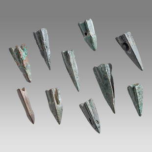
Sold2023Lot of 10 Ancient Roman Bronze Arrow Heads c.1st century AD.Lot of 10 Ancient Roman Bronze Arrow Heads c.1st century AD. Size 0 3/4 - 1 inch length. Fine cast bronze, Eastern Europe Roman empire arrow heads. Fine patina. Ex FL Collection.See Sold Price
Sold2023Lot of 10 Ancient Roman Bronze Arrow Heads c.1st century AD.Lot of 10 Ancient Roman Bronze Arrow Heads c.1st century AD. Size 17-30 mm length. Fine cast bronze, Eastern Europe Roman empire arrow heads. Fine patina. Ex FL Collection.See Sold Price
Sold2023Lot of 10 Ancient Roman Bronze Arrow Heads c.1st century AD.Lot of 10 Ancient Roman Bronze Arrow Heads c.1st century AD. Size 15-27 mm length. Fine cast bronze, Eastern Europe Roman empire arrow heads. Fine patina. Ex The Time Machine.See Sold Price
Sold2023Lot of 10 Ancient Roman Bronze Arrow Heads c.1st century AD.Lot of 10 Ancient Roman Bronze Arrow Heads c.1st century AD. Size 15-24 mm length. Fine cast bronze, Eastern Europe Roman empire arrow heads. Fine patina. Ex FL Collection.See Sold Price
Sold2018Weller: Antique Map of Roman Empire in the 4th CenturyTitle/Content of Map: Roman Empire (Eastern & Western) in The 4th Century. Date Printed: 1877 ca. Cartographer: WELLER, EDW. Publisher: G.P. PUTNAM'S SONS 1877 ca. NEW YORK Size: Quarto – 6.00 H x 8See Sold Price
Sold20221747 Two Engraved Maps of Roman EmpireTitle: 1747 Two Engraved Maps of Roman Empire Additional Information: Two engraved maps of the Roman Empire in its "Infancy" and at its "Youthful Age", both published by John and Paul Knapton, London,See Sold Price
Sold2020Barbarian Europe Post Roman Empire 1896Title: Barbarian Europe Post Roman Empire 1896 Date Printed: 1897 Cartographer: Materials: paper Dimensions: Approx. 11x14.5 inches Additional Info: Cram's Universal Atlas Geographical, Astronomical aSee Sold Price
Sold2022Nat. Encyclo. 1891 Lot of 4 Maps. Italy & Roman EmpireLithograph Map Published 1891-1901 by William Mackenzie, London for "The National Encyclopedia: A dictionary of Universal Knowledge" Centre Fold as issued. Paper Size: 12 x 9.5 inch (31 x 24cm) Good CSee Sold Price
4 days LeftJasper52The Rise and Fall of the Roman Empire 9 of 12 Volumes 1815 Leather Maps Gibbon$1,000
5 days LeftJasper521700 Schenk Map of Russian Empire -- La Russie Blanche ou Moscovie Divisee Suivant l'Estendue des$240
5 days LeftLeland LittleRoman Empire, Five (5) High Grade Silver Denarii Featuring the "Adoptive Emperors"$90(2 bids)