Sold2018(2) Late 19th c. maps of Ireland, unframedTwo late 19th century colored maps of Ireland, comprising a map of Ireland printed for The Century Atlas, circa 1897, 16"h x 11"w, unframed, and a map of Ireland printed for The Society for the DiffusSee Sold Price
Sold2020Map of West Indies, Cuba & South AmericaMap of West Indies and Island of Cuba PLUS South America on verso Two maps on one sheet. (back to back). Hand colored. [See photos] Maker: No caSee Sold Price
Sold2024Abraham Ortelius Tempe "View of Mount Olympus" Colored Map Circa 1600Circa 1603 - Abraham Ortelius View of The Paradise of Tempe at the foot of Mount Olympus. This map was originally published in 1595. While we are unable to identify the exact date of this image, it isSee Sold Price
Sold2017Thomas Kitchin, Maryland and Scotland maps(Scottish, 1718-1784)., "Map of Maryland with the Delaware counties and the southern part of New Jersey," hand colored map, circa 1750, 7 x 9 in. , framed and "Scotland," circa 1760, 7 1/2 x 9 in. , fSee Sold Price
Sold2017John Carey. North America map(English, 1754-1835). "Part of North America comprehending Ohio, New England, New York, New Jersey, Pennsylvania, Maryland, Virginia, Carolinas & Georgia" (sic) hand colored map, circa 1782, 9 1/2 x 1See Sold Price
Sold2021Antique 18th C Imperium Turcicum Hand Colored MapAntique 18th C Imperium Turcicum Hand Colored Map. Circa 1730s. The map shows the Ottoman Empire with an area between Ukraine and Black Sea in the north, Persia / Iran in the east, Arabia and Egypt inSee Sold Price
Sold2023TWO 1835 CONSTELLATION MAPS2 framed antique constellation hand colored maps circa 1835 by DFJ Huntington of Hartford CT, printed by WG Evans of NY - Plate V and Plate VI Northern Circumpolar. Each 14.5 x 13.5 image, framed 19 xSee Sold Price
Sold2019Nicolao Visscher. Orbis Terrum Nova MapNicolao Visscher (Dutch, 1618-1709). A hand-colored engraved map, circa 1658. Orbis Terrum Nova et Accuratussna Tabula. Showing partial coastlines of New Zealand and Australia. Unframed. 23-1/2 in x 2See Sold Price
Sold2021Antique MapsGrouping of Two (2) Antique Engraved Maps. Includes a J.H. Colton & Co hand colored map of Cuba, Jamaica, and Puerto Rico together with a Jacques-Nicolas Bellin "Carte de la Nouvelle Angleterre, NouveSee Sold Price
Sold2021COLLECTION OF EPHEMERA TO INCLUDE WOMAN'S HOMECOMPANION MAP OF CUBA 1897, BIG GAME TARGET, 2 WATERCOLORS OF FLOWERS BY EUGENIA SCHWENDER AND 6 MISC. CHROMOLITHS DEPICTING ANIMALS & CHILDRENSee Sold Price
Sold202317TH C. HAND COLORED MAP OF BERMUDA - CIRCA 167017TH C. HAND COLORED MAP OF BERMUDA - CIRCA 1670 - TITLED "MAPPA AESTIVARUM INSULARUM ALIAS BARMUDAS" - FRAMED AND IN VERY GOOD CONDITION - FRAME 21 3/4" X 19 1/8", SIGHT 14 3/4" X 11 3/4"See Sold Price
Sold2018JOHN RAPKIN (English 19th Century) and J. MARCHANTJOHN RAPKIN (English 19th Century) and J. MARCHANT (Australian 19th Century) A HAND COLORED MAP, "North America," CIRCA 1851, the map of North America with hand colored outlines of each country and stSee Sold Price
Sold2017Old Map of 1873 "Colton's Dakota"Old Map entitled "Colton's Dakota". Purchased by the consignor as "an original hand colored tinted map from circa 1873". Published by G.W. (and) C.B. Colton & Co. No. 172 William St. New York. At bottSee Sold Price
Sold2020Hand Colored Map Of ItalyHand colored map of Italy, Robert circa 1770, 13" x 14" unframed, 20" x 21" framed. Provenance: John's Island, Vero Beach, Florida.See Sold Price
Sold20243 Antique Helvetian Engraved Maps, 17th/18th CProperty from the Estate of a Swiss UBS Executive, Zurich and Hilton Head Island, SC Description: 3 Antique Helvetian Engraved and Hand-Colored Maps, 17th/18th C, circa 1683 - 1715, depicting portSee Sold Price
Sold20164 Hand colored early maps4 Hand colored early maps including Normandie, circa 1940. Taped; stained; tears; several small holes. 24 1/2 inches wide x 19 inches high.See Sold Price
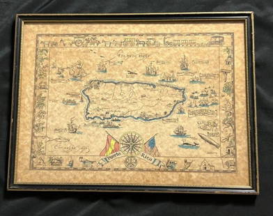
Sold2023Vintage Hand -Colored Pictorial Map of Puerto Rico Circa 1931 by E.B.K. DooleyA vintage hand-colored map of Puerto Rico by E.B.K. Dooley, published c. 1931. This map has a decorative border filled with local plants, wildlife, buildings and transportation. In small scrolls, therSee Sold Price
Sold2022Brockhaus (Pub) 1897 Map of Cuba, Jamaica & Puerto RicoLithograph Map Published 1892-98 by F. A. Brockhaus, Leipzig for "Brockhaus' Konversations-Lexikon" by Various. Paper Size: 10 x 6 inch (25 x 16cm) Good ConditionSee Sold Price
Sold2024Abraham Ortelius (Belgian 1527 - 1598)Abraham Ortelius (Belgian 1527 - 1598) "Maris Pacifici", circa 1603 Hand Colored map engraving of the Pacific Ocean 14" x 20" Condition: aging, yellowing to paper, undulation, center folds, some fadinSee Sold Price
Sold2024Adam Friedrich Zurner (German 1679 - 1742) and Peter Schenk (German 1660 - 1711)Adam Friedrich Zurner (German 1679 - 1742) and Peter Schenk (German 1660 - 1711) "Americae tam Septentionalis quam Meridionalis in Mappa Geographica Delineato", circa 1709 Hand colored map engraving 2See Sold Price
Sold2021Cuban Ephemera [132594]Large collection of Cuban trade cards, travel brochures, hotel sticker/labels, a foldout map and History of Cuba published 1897 including a clear and graphic account of the War of 1895-1897, by Lt. E.See Sold Price
Sold2015A New Map of the East IndiesTaken from M. de Fer's Map of Asia by Edward Wells (1667-1727), circa 1700, hand-colored map was part of a set of 22 maps dedicated to William, Duke of Gloucester, title cartouche includes the Royal CSee Sold Price
Sold2020Angliae, Scotiae, Et Hiberniae MapCirca 1575; hand colored map of England and Scotland by Abraham Ortelius (1527-1598), 19 x 13 1/2 in., framed.See Sold Price
Sold2023JOOST DE HONDT, HAND COLORED MAP OF CASTILEJoost de Hondt aka Jodocus Hondius the elder (Flemish 1563-1612), "Castiliae Veteris et Novae Descriptio" circa 1620, hand colored map of Castile, unframed. Provenance: From the Estate of C.T. and WilSee Sold Price
4 days LeftTrillium Antique Prints & Rare BooksStrickler, Rare - Strickler, Rare - Brazilian Forest$200
May 18Blackstone Valley Auctions & Estates LLCRevolutionary Era War Map of the Attack on Ft. Moultrie.$120(2 bids)
May 16Heritage Auctions74186: A Six-Piece Gorham Mfg. Co. Silver Tea & Coffee $3,000


![Map of West Indies, Cuba & South America: Map of West Indies and Island of Cuba PLUS South America on verso Two maps on one sheet. (back to back). Hand colored. [See photos] Maker: No ca](https://p1.liveauctioneers.com/5614/161325/81425362_1_x.jpg?height=310&quality=70&version=1581106272)


![Cuban Ephemera [132594]: Large collection of Cuban trade cards, travel brochures, hotel sticker/labels, a foldout map and History of Cuba published 1897 including a clear and graphic account of the War of 1895-1897, by Lt. E.](https://p1.liveauctioneers.com/2699/211842/108080555_1_x.jpg?height=310&quality=70&version=1626732910)


