Sold2020Early map of Florida in full hand colorStriking map of Florida with only sixteen counties. Lower 2/3 dominated by three large counties. Wide margins. With three inset maps: Pensacola, Tallahassee and Harbour of St. Augustine. Shows table oSee Sold Price
Sold2021Map- Pieter Goos Oost Indien - 1666Early map - Pieter Goos. Pascaetre Van'T Westslycke Deel Van Oost Indien. Amsterdam 1666. Full hand color. H 17-3/4" W 22-1/2". Provenance : Philadelphia print shop. CONDITION: Excellent. Please copySee Sold Price
Sold201718th Century French Map of North AmericaL’Amerique Septentrionale. Daniel de la Feuille (1640-1709). Engraved map with hand color in full. Amsterdam, 1702 or 1706. 6 x 8 inches visible, 13 x 14 1/2 inches framed. Nicely colored early 18thSee Sold Price
Sold2020ORTELIUS, ABRAHAM. La Florida / Guastecan / Peruviae.ORTELIUS, ABRAHAM. La Florida / Guastecan / Peruviae. Double-page engraved sheet with three maps. 17x20½ inches sheet size; wide margins, Latin text on verso; original hand-color in full; minor mSee Sold Price
Sold20201861 Civil War military map in full hand-colorLarge format, double-page “Johnson’s New Military Map of the United States showing the Forts, Military Posts &c. with Enlarged Plans of Southern Harbors” by Johnson and Ward. Original and vividSee Sold Price
Sold2017Colton: Antique Map of Minnesota, 1855Extremely clean 1855 Colton map of Minnesota. From the 1856 edition of Colton’s Atlas of the World. A virtually spotless map. Lovely full hand-color and impression. Two tiny, light margin spotsSee Sold Price
Sold2023Civil War era map of Florida, 1863Lovely early map of Florida, vividly hand colored by county, with a large inset of the Florida Keys. Shows towns, railroads, villages, post offices, forts, etc. Only five counties shown in the southerSee Sold Price
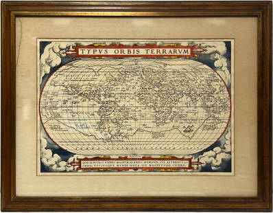
2023Early World Map "Typvs Orbis Terrarvm" Hand ColorDated 1590 near bottom legend box. Hand colored, with red and orange watercolor prominent in the titles. Blue clouds in border. Some slight use of yellow in the boundaries of the map. With signature oSee Sold Price
Sold2019MAP - Ohio. MeyerOhio. Joseph Meyer, Neueste Karte von Ohio mit Seinen Canaelen, Strassen & Entfernungen der Hauptpunkte. Nach den Bessten Quellen Verbessert, 1845 (dated). Hand Color. Fine early map showing counties,See Sold Price
Sold2022Uncommon Hardesty map of upper Northwest US, 1875Nice, elusive early map of northwest territories with vintage original full hand coloring. Idaho and Washington still seen as Territories. ?Map of Washington Oregon and Idaho? published 1875 by HigginSee Sold Price
Sold20171848 Houze ATLAS Geography 101 MAPS Europe Africa1848 Houze ATLAS Geography 101 MAPS Europe Africa America Hand-Colored England A rare 19th-century atlas filled with over 100 full-page maps hand-traced in color. These maps by Antoine Philippe HouzeSee Sold Price
Sold2016Early Map of The Michigan Territory by CareyThe Upper Territories of the United States, 1814. Matthew Carey (1760-1839). Engraved map with original hand color in outline. Philadelphia, 1814. 22 x 17 1/4 inches sheet. The map reflects a very earSee Sold Price
2017Colton: Map of Nebraska & Kanzas, 1855Map: Nebraska and Kanzas Cartographer: J. H. Colton Illustrator: J. H. Colton Publisher: J. H. Colton, Co. Published: New York, 1855 Size: 12.5 x 15.75 inches Extremely nice example with full hand-colSee Sold Price
Sold2021Early map of Michigan plus Wis. and Iowa Territories,Title: Early map of Michigan plus Wis. and Iowa Territories, 1844 Description: Nice steel engraved map with full hand coloring. Map shows both parts of Michigan plus the Wisconsin and Iowa TerritoriesSee Sold Price
Sold2017Important early map of St. Johns Island by T. JefferysA Map of the Island of St. John in the Gulf of St. Laurence...Thomas Jefferys (c. 1719 – 1771). Copperplate engraved map with handcolor in outline. London: Sayer & Bennett, 1775. 21 1/2 x 29 inchesSee Sold Price
Sold2019Bellin Map of the CarribeanBELLIN, Jacques Nicolas (1703-1772). Carte du Golphe du Mexique et des Isles de l'Amerique... Engraved map with hand color in full. Paris, 1754. 11 3/8” x 15 1/4” visible, 16 1/2” x 20” framedSee Sold Price
Sold2023MAP, Tennessee, CareyCarey's Early Map of Tennessee. Tennessee. Mathew Carey, The State of Tennessee, from Carey's General Atlas, 1814 (circa). Hand Color. This fine map of Tennessee shows the state at an early point in iSee Sold Price
Sold2022[MAP-FLORIDA] VANDERMAELEN, PHILIPPE MARIE. Florides et Iles Lucayes. [Brussels:] August 1825.[MAP-FLORIDA] VANDERMAELEN, PHILIPPE MARIE. Florides et Iles Lucayes. [Brussels:] August 1825. Lithographed map with hand-color. Lithographed by H. Ode. 19 1/4 x 21 1/2 inches (49 x 55 cm); matted andSee Sold Price
Sold2017Seutter Africa MapAfrica juxta navigationes et observat recentissimas.. Matthias Seutter (1678-1757). Augsburg, J.M.Will, 1778. Engraved Map with Hand color in full. 8 1/4 x 10 1/2 inches visible, 15 1/2 x 17 inches frSee Sold Price
Sold2022Extremely rare map of Europe by John Cooke, 1800Highly unusual circular format makes this extremely rare map even that much more special. From The Universal Atlas of John Cooke, published in 1802. Full original hand color. A clean, sound map that wSee Sold Price
Sold2023Very rare map of Norway and Sweden, John Cooke, 1802Extremely rare miniature map in an unusual circular format. From an 1802 edition of The Universal Atlas, published by John Cooke and J. Harris in London. Dated Jan. 1, 1802. Full original hand color.See Sold Price
Sold2023Extremely rare map of Germany by John Cooke, 1800Desirable and rare miniature map in a circular format. From an 1802 edition of The Universal Atlas, published by John Cooke and J. Harris in London. Full original hand color. Tiny water stain at top pSee Sold Price
Sold2023Scarce and fine 1894 hand-colored RR map of FloridaScarce, distinctive double-page map of Florida from likely the last American atlas to feature hand-color on its maps. Good representation of the swampy areas in the southern portion of the state. InseSee Sold Price
Sold2020Laurie & Whittle Map of AmericaLAURIE & WHITTLE (Late 18th Century)The United States of America...Engraved map with original hand color in full.London: Laurie & Whittle, 1794.20 1/4" x 22 1/2" sheet.The first British map to show thSee Sold Price
Jun 08Early American History Auctions1853 Washington Crossing the Delaware Engraving by Paul Girardet, After the Oil Painting by E. LEUT$3,000
May 28Signari GalleryART PROSTITUTE 'Original Magazine + Print Series' (2003-2005) Box Set Vol. 1-4$100
Jun 08Early American History Auctions1836 Hand-Colored Map, Country Twenty Five Miles Round The City Of New-York Published by D.S. Stone$260
2 days LeftPotter & Potter Auctions[COLOR PLATE BOOK]. KELLY, Christopher. History of the Fren...$350
1 day LeftJasper52Turkestan, or Independent Tartary by Edward Weller. Central Asia 1860 old map$40(1 bid)
2 days LeftSouth Florida Auction & Estate Sale Services IncComplete Set Painted Ladies Pin up Girl Art Trading Cards from the 40’s and 50’s$6
Jun 04High End Auction House LLC(Early Print) IGS 1964 7-7 THE ROLLING STONES - THE ROLLING STONES - vinyl record graded$1,100(3 bids)


![[MAP-FLORIDA] VANDERMAELEN, PHILIPPE MARIE. Florides et Iles Lucayes. [Brussels:] August 1825.: [MAP-FLORIDA] VANDERMAELEN, PHILIPPE MARIE. Florides et Iles Lucayes. [Brussels:] August 1825. Lithographed map with hand-color. Lithographed by H. Ode. 19 1/4 x 21 1/2 inches (49 x 55 cm); matted and](https://p1.liveauctioneers.com/292/250642/130213663_1_x.jpg?height=310&quality=70&version=1654271664)


![[COLOR PLATE BOOK]. KELLY, Christopher. History of the Fren... (1 of 3)](https://p1.liveauctioneers.com/928/328184/176813585_1_x.jpg?height=282&quality=70&version=1714496988)


